|
The Fullerton Loop
|
Please e-mail comments, corrections and additions to the webmaster at pje@efgh.com.
|
|
The Fullerton Loop
|
Please e-mail comments, corrections and additions to the webmaster at pje@efgh.com.
The Fullerton Loop is a popular ride in Orange County, but I first found out about it when I was exploring the Juanita Cooke Trail in 2004 and saw a map posted next to the trail. It is supposed to be approximately 12 miles long, but I have measured it at approximately 10.1 miles.
I found the map on the World Wide Web and used it to follow the trail. Of course, I went astray in a few places, but I've been able to piece together a description detailed enough so the next visitor can follow the route more easily.
On October 20, 2011, I rode the trail again. This is an updated description with approximate distances and some approximate latitudes and longitudes. There have been only a few significant changes:
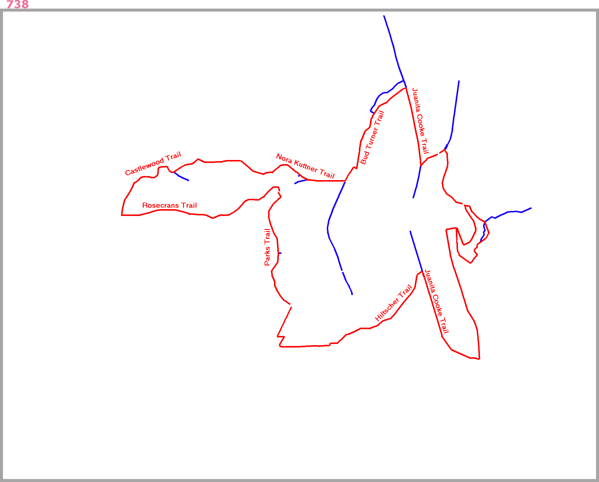
The map on the World Wide Web consisted of a marked up topographic map, part of the La Habra quadrangle. Unfortunately, this quadrangle was last updated in 1981, so it doesn't show many of the newer streets and other landmarks. A much more useful map can be obtained by marking up page 738 of the Orange County Thomas Guide, which doesn't show topographic features, but does show all the streets.
The Thomas Guide is copyrighted, so I can't legally post a copy of that page. That would go beyond the bounds of fair use.
But YOU can scan page 738 of YOUR copy and use my overlay to mark the trail on it. Try to use a resolution of 200 dots per inch, because this is the size that will fit the overlay. Then download the Fullerton Loop Overlay and use an image editing program to add it to the scanned map, adjusting the size if necessary.
The Fullerton Loop is shown on the overly in red. Some of the side trails (but not all of them) are shown in blue. A border on the overlay matches the border on the Thomas Guide map and can be used for alignment.
A topographic map with essentially the same overlay is also posted. It may be of limited use, because the topographic background isn't up-to-date.
The usual starting and finishing point for the Fullerton Loop is on Berkeley Ave. just west of Harbor Blvd. (Thomas H6). It has easy freeway access from the Harbor Blvd. interchange with Interstate 5, and parking is available on the street near the trail and in the courthouse parking lot next to the trail.
The loop begins at the south end of the Juanita Cooke Trail on Berkeley Ave., just a short distance west of Harbor Blvd. The trail was unsigned in 2004; there is now a very small sign, but the trail is fairly obvious.
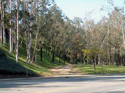
The south end of the Juanita Cooke Trail.
N 33o 52.771 W 117o 55.543
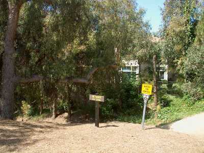
Most of the Juanita Cooke Trail is fairly flat because it was built on an old railroad right of way. Follow it north across Valley View Dr. (mile 0.2) and N. Richman Ave. (mile 0.5) and turn left into the signed Hiltscher Trail (mile 0.7). There are some benches at this trail junction, so it would make a good rest stop.
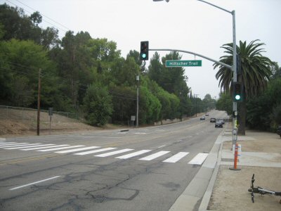
The beginning of the Hiltscher Trail.
N 33o 53.364 W 117o 55.913
The Hiltscher Trail runs almost entirely downhill through an undeveloped area along a creek. After the trail crosses Richman Knoll (mile 0.9), it enters Hiltscher Park. In this area there are actually two trails. The main trail runs along the north side of the creek, and a narrower trail runs along the south side. (The trails are too close to be shown separately on the map.)
Where the trail crosses Euclid Street (mile 1.4), there are a few parking spaces on the east side. There is now a signed crosswalk with a button-activated signal. (There was no signal in 2004).
Hiltscher Trail crosses Euclid St.
N 33o 52.926 W 117o 56.511
On the date of my last survey (October 20, 2011), the trail beyond Euclid Street was closed for construction, and I had to follow a detour. The trail was reopened by the date of this writing (May 5, 2012). The description in the following paragraph is probably still fairly accurate.
West of Euclid St. the trail splits. Take the right branch, which goes steeply uphill. (The left branch follows a drainage ditch and emerges on Arroyo Dr.)
At the top of the hill, there is another small parking area, and the trail emerges on W. Fern Dr. approximately opposite W. Valley View Dr. (mile 1.5).
Follow W. Valley View Dr. west all the way to its end. Turn right on Bastanchury Rd. (mile 1.90) and then left on Warburton Way (mile 1.96). Bastanchury Rd. is a very busy street, but there is a traffic light with a left turn pocket at the intersection.
Just before a railroad grade crossing (mile 2.01), turn right and ride north next to the railroad tracks to the next grade crossing at Parks Rd. It appears that the railroad is not currently in use; the tops of the rails are not polished.
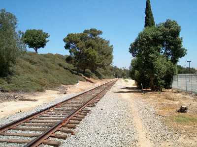
The Fullerton Loop runs next to a railroad between
Warburton Way and Parks Rd.
Cross Parks Rd. (mile 2.3) turn left, cross the tracks and enter the Parks Trail, which runs next to Parks Rd. on the right (northeast) side.
Follow the Parks trail north through Edward White Park, then past a school and through Roger B. Chaffee Park. to Rosecrans Ave.
Cross Rosecrans Ave. with care (mile 2.8). It carries a lot of traffic. There is a button-activated traffic control device of some kind, but it seems to be of the "warning light" kind.
Enter Virgil "Gus" Grissom Park and follow a narrow asphalt path, which runs next to a drainage ditch.
The Parks Trail through Virgil "Gus" Grissom Park is paved
and next to a drainage ditch.
The path emerges on Camino Rey (mile 3.3). On the other side of the street, and a short distance to the right (east), an unpaved path runs north and soon turns west. It is not clear whether this is part of the Parks Trail, but it is surely part of the Fullerton Loop.
The trail crosses Parks Rd. (mile 3.5) and enters the West Coyote Hills Tree Park, which is signed simply as "Tree Park".
There are two trails through the park. To the left (south) is the higher trail, which is closed to bicycles because it contains a very steep hill.
Bicyclists must follow the lower trail. When it leaves the park, it runs right next to Coyote Hills Dr. For a short distance (about 200 feet) you will have to ride on the sidewalk because there is no unpaved trail.
The trail soon veers left away from Coyote Hills Dr. (mile 3.7). It then approaches Rosecrans Ave. (mile 3.75) and turns right to run parallel to Rosecrans Ave. and north of it. This part is signed as the Rosecrans Trail, and it consists of both a paved sidewalk and an unpaved path. (There is a second sidewalk right next to the street.)
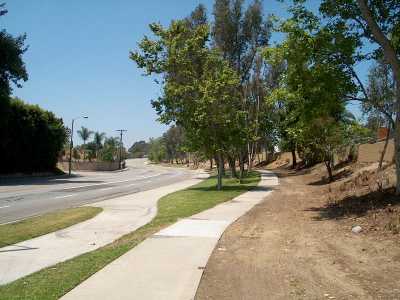
The Rosecrans Trail has paved and unpaved parts.
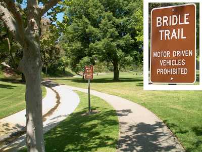
Where the Rosecrans Trail comes to an end (mile 4.5), the signed Castlewood Trail begins. It runs north and east around a residential area, coming quite close to the streets in some places.
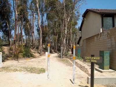
The Castlewood Trail begins where the Rosecrans Trail ends
next to Rosecrans Ave.
N 33o 53.751 W 117o 58.314
At one point (mile 5.1), a side trail veers right (south) and descends to N. Gilbert St. Keep left to stay on Castlewood Trail.
The main trail continues and reaches N. Gilbert St. near Chantilly Lane (mile 5.6).
N. Gilbert St. is a busy street, but there is a traffic light with a pedestrian signal that bicyclists can use to cross safely and easily.
The trail continues west along the north side of Castlewood Dr.
Where Castlewood Dr. meets Parks Rd. (mile 5.8), turn left (north) into the signed Nora Kuttner Recreational Trail.
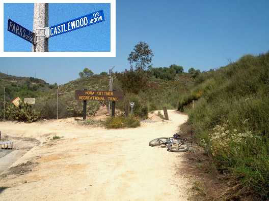
The Nora Kuttner Recreational Trail begins at the
corner of Parks Rd. and Castlewood Dr.
N 33o 53.991 W 117o 57.133
The Nora Kuttner Trail runs east as far as Euclid St. There are good views of the Robert E. Ward Nature Preserve just to the north. The trail emerges on Euclid St. roughly a block south of Laguna Rd., right next to the entrance to the preserve (mile 6.5).
Cross Euclid St., using the button-activated signal. However, the signal doesn't stop cars; it merely displays a flashing amber light while you cross. Enter the Bud Turner Trail, which runs along the other side of the street. Turn left and go north to the next intersection and turn right on Laguna Rd. (mile 6.7).
Some bicyclists may prefer to ride north near the west side of Euclid St. to the intersection with Laguna Rd. and use the pedestrian signal to cross there.
Turn left into Laguna Lake Park opposite Yuma Way (mile 6.71).
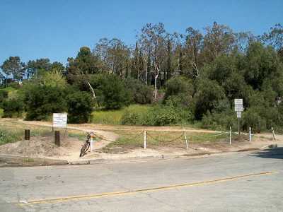
The Bud Turner Trail enters the Laguna Lake Park on Laguna
Rd.
N 33o 54.032 W 117o 56.416
The Bud Turner Trail splits into two parts. The lower trail is fairly wide and smooth, and runs through an open area next to an equestrian center. The upper trail is narrow and runs through a wooded area. (The trails are too close to be shown separately on the map.)
Where the two parts come together, near the Fullerton Recreational Riders corral (mile 7.0), the trail gets a little vague. The upper trail runs up over a small hill and descends into a parking area on the south side of Clarion Dr. just east of Lakeview Dr. The lower trail goes around the hill to the same place. (This parking area is actually a good alternative place to begin and end the loop.)
The trail crosses Clarion Dr. (mile 7.3) and then runs northeast next to Laguna Lake. It appears that the trail runs along the southeast side, although there is also a trail along the northwest side.
The trail then crosses Lakeside Dr. at a marked crosswalk (mile 7.3) and meets another part of the Juanita Cooke Trail. (There are signs for the Bud Turner and Juanita Cooke Trails near this point, but you are not likely to see them, because they face W. Hermosa Dr.)
Turn right and follow the Juanita Cooke Trail south until it crosses over a railroad (part of the same one you followed earlier). On the south side of the railroad (mile 7.8), turn left and descend steeply to the railroad. (A gentler descent is available if you go a little farther and then turn back.)
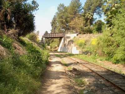
An old railroad trestle carries the Juanita Cooke Trail
over a railroad spur. The path near the tracks is part of the Fullerton
Loop.
N 33o 54.032 W 117o 55.888
Follow the railroad east, passing under N. Harbor Blvd. Be careful, because the path runs quite close to the tracks in some points. It appears that the railroad is not in use; the tops of the rails are not polished.
Turn right into a small side path (mile 8.0). (If you come to a grade crossing, you have gone too far.) The path runs next to a paved road for a short distance, then crosses over the road (mile 8.04) and runs next to the Fullerton Golf Course.
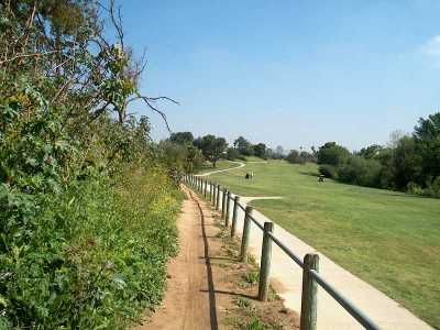
The Fullerton Loop runs next to the Fullerton
Golf Course.
At the south end of the golf course (mile 8.5), the path runs through two large culverts under Bastanchury Rd. On the other side is the Brea Dam Recreational Area.
There are quite a few trails, both formal and informal, through the Brea Dam Recreational Area. If you head generally south, you won't get lost.
After passing under Bastanchury Rd., the trail splits. The easier route is to the right (west). Follow it south until you come to the Brea Dam (mile 8.9), and then turn right and ride next to the dam up to the northwest side.
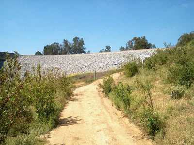
The easier branch of the Fullerton Loop runs up the edge
of the Brea Dam.
The more difficult route is to the left (east), and it may be closed if access to the dam is ever shut off. The trail leads directly to a four-way intersection of trails. Do not turn left, because this is a side trail that leads away from the dam. Go straight ahead.
When you approach the dam, you will notice two gravel roads leading uphill and to the left. Take the second road (although the first probably goes the same place) up to a large clearing. Turn right and follow the road up to the dam. There is a pipe gate across the road, but it is unsigned and easy to pass through or over.
Then cross the dam to its northwest end. There is another gate at the end, but you can get around it by lifting your bike over a low wall.
Either of these routes will take you to the parking lot for the Fullerton Tennis Center (mile 9.0 by the shorter route).
Go west along E. Valencia Mesa Dr. to Harbor Blvd.
Turn left (mile 9.06) and ride south on Harbor Blvd. Turn right on Berkeley Ave. to return to the starting point (mile 10.1).
If you prefer to do a little more offroad riding, instead of turning left on Harbor Blvd. continue straight ahead on E. Valencia Mesa Dr. (which becomes W. Valencia Mesa Dr. when it crosses Harbor Blvd.) Just before the road crosses over the Juanita Cooke Trail (mile 9.2) turn right into a fairly steep, unpaved driveway that descends to the trail. Turn left and follow the Juanita Cooke Trail back to the starting point (mile 10.1).