|
|
Bicycling on Old U.S. 395 in San Diego County |
Please e-mail comments, corrections and additions to the webmaster at pje@efgh.com.

Background | Directions for Northbound Bicyclists | Directions for Southbound Bicyclists
U.S. Highway 395 used to be a major highway connecting San Diego and the inland parts of California directly to the north. It has been completely replaced by Interstate 15 in San Diego County.
South of Escondido, very little of U.S. 395 is still recognizable. However, there is a convenient bike route parallel to Interstate 15.
North of Escondido, old U.S. 395 still exists and has bike lanes in most places. Most of the through traffic has moved to Interstate 15, making the old highway a good bike route, except for several rather substantial hills.
Return to home page
Directions for Northbound Bicyclists
00.00 Start at the corner of Orange Ave. and Fairmount Ave. Proceed north on Fairmount Ave.
01.75 - Enter a small bike path at a sign that says "Bicycles Must Exit". The path will carry you safely over the onramps to Interstate 8.
02.05 - At the end of the bike path, turn left onto Camino del Rio North.
02.59 - Turn right onto Ward Rd.
02.71 - Turn left onto an unmarked road just past 24 Hour Fitness.
02.93 - Pass under Interstate 15 and into the Qualcomm Stadium parking lot. Keep right and ride north along the east side of the parking lot.
03.20 - Enter the Murphy Canyon bike path near the northeast corner of the parking lot.
03.93 - Emerge from the bike path and continue north on Murphy Canyon Rd.
06.69 - Turn left onto Clairemont Mesa Blvd., using the pedestrian crossing signal if the left-turn traffic light does not respond.
06.80 - Turn right onto Chesapeake Dr.
07.33 - Turn right onto Ruffin Rd., which becomes Kearny Villa Rd.
11.53 - Turn right onto Pomerado Rd.
11.80 - Cross over Interstate 15, watching carefully for cars entering or leaving the freeway.
Pay no attention to the spurious signs that say "Entering San Diego County" and "Leaving San Diego County". You are in San Diego County and will remain in San Diego County for many miles to come. These signs mark a small unincorporated area surrounded by the City of San Diego.
15.65 - Turn right at the top of the hill to stay on Pomerado Rd. To the left would be Spring Cyn Rd. Straight ahead would be Cypress Cyn Park Dr.
16.52 - Leave the City of San Diego and enter Poway, the City in the Country.
19.79 - Arbolitos Park to the right. A good place for a rest stop. Restrooms, drinking fountain, telephone are available.
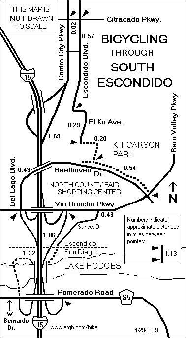
25.74 - Turn left into the onramp to Interstate 15 NORTH. Yes, it is legal to ride on the freeway shoulder. Enter the City of Escondido as you cross over Lake Hodges. Take the first exit, Via Rancho Parkway.
26.81 - At the end of the Via Rancho Parkway offramp, use the pedestrian crosswalk to cross the offramp and turn around. Enter the Interstate 15 NORTH onramp. Take the first exit, Centre City Parkway. (The map also shows alternate routes through or around North County Fair Shopping Center.)
31.44 - Cross Mission Ave. (This is a major bike route to the west.)
31.61 - Pass under Highway 78.
34.32 - Leave the City of Escondido.
36.85 - Intersection of Deer Springs Road and Mountain Meadow Road. Continue straight ahead on Champagne Blvd.
39.60 - Welk Resort, gas station and food market to the right.
41.11 - Intersection of Gopher Canyon Road. continue straight ahead on Old Highway 395.
42.10 - Shift to a lower gear and begin climbing a long, rather steep hill.
43.61 - Pass over Interstate 15. Watch out for open expansion gaps on this bridge.
44.47 - Stop climbing and start coasting down the other side of the hill.
44.73 - Cross West Lilac Road.
46.40 - Cross the San Luis Rey River.
46.85 - Cross Highway 76, which is a major east-west route. It is not a very good bike route, because the traffic is heavy and the shoulders are narrow.
50.19 - Pass Reche Rd.
51.25 - Turn right to stay on Old Highway 395 and cross over Interstate 15.
51.49 - Turn left to stay on Old Highway 395.
53.01 - Cross Rainbow Glen Rd. and Rainbow Valley Blvd.
53.60 - Pass Fifth St. and a small shopping district with a restaurant and food market.
55.01 - Cross Rainbow Valley Blvd.
55.28 - Leave San Diego County and enter Riverside County. Old U.S. 395 becomes Frontage Rd. and then Rainbow Canyon Rd.
56.70 - The highest point on the route. (What's a factory doing way up here?) Start the descent into Temecula Valley.
57.98 - Entrance to Temecula Creek Inn, and the road levels out.
58.50 - Corner of Pala Rd. and Rainbow Canyon Rd.
Return to home page
Directions for Southbound Bicyclists
The southbound route is the exact opposite of the northbound route, except in south Escondido. See the following document for details: