|
|
Red Routes
|
 |
 |
 |
Please e-mail comments, corrections and additions to the webmaster at pje@efgh.com.
 |
 |
If you dislike riding your bicycle in traffic, the red
routes on the RideLink bike map may appeal to you. A route marked in
orange ink is supposed to be a "completely
separate right-of-way for the exclusive use of non-motorized travel".
(Previous editions of the map showed such paths in red.)
The RideLink bike map is available free of charge. Go to www.icommutesd.com and navigate to "Bike to Work". You can also order a printed copy, which is now available. Printed copies may also be available at some bike shops and other locations. |
The City of Oceanside (a Bicycle Friendly Community, according to the League of American Bicyclists), has published its own bicycle map, using a similar color scheme.
I've been exploring the red routes of San Diego County for more than fifteen years. I've ridden every one shown on the RideLink bike map, except in a few cases where the route could not be found or access was blocked by fences and locked gates. I've also included a number of bike paths that are not shown on the RideLink map, and a few in nearby counties. I'm adding paths from time to time as I locate and explore them.
Every red route has been given a name, but in most cases the name is unofficial. In fact, I've had to assign most of the names myself.
For brevity, each path is described in only one direction. However, all of these paths are two-way bike paths except where specifically noted otherwise.
All of these paths, except the uncompleted ones, are paved.
Recently, for the convenience of the increasing numbers of GPS users, I've added latitude and longitude coordinates of bike path ends and access points, using a format supplied by my Garmin eTrex GPS. This format is acceptable to mapping sites such as Google Maps. Some other sites, however, require an all-degree format, so I have supplied a Latitude and Longitude Convertor, which will convert one format to the other.
Philip J. Erdelsky pje@efgh.com
This bike path is San Diego County's longest continuous red route. It begins on the west side of the junction of Main Street and Frontage Rd. (Thomas 1330 A5, N 32 35.260 W 117 05.560), near the Main Street exit from Interstate 5. It runs west along the south end of San Diego Bay and then north up the Silver Strand just east of Highway 75.
All of the path between Main Street and 13th Street, and most of the path between 13th Street and 7th Street, is fenced, and there is no access to the neighborhoods to the south. However, there are connections to the north ends of 13th Street (N 32 35.249 W 117 06.344), 12th Street (N 32 35.276 W 117 06.481), 8th Street (N 32 35.446 W 117 06.929) and 7th Street (N 32 35.468 W 117 07.081).
The portion between Main Street and 13th Street was opened on April 18, 2009. It was sometimes referred to as the Western Salt path, because a company by that name owns the South Bay Salt Works, which owns the salt-evaporation ponds just north of the path.
About 0.8 miles north of Coronado Cays Blvd., near the north end of Silver Strand State Beach, is a place where bicyclists and pedestrians can enter the east side of Silver Strand State Beach, where there are rest rooms and a drinking fountain. There are tunnels under Highway 75 to the west side. (The rest rooms may be closed due to budget constraints.)
For about a mile north of the Fiddler's Cove Marina and RV Park (N 32 39.131 W 117 9.050), there is a separate, unpaved footpath east of the bike path. It runs through a nature preserve signed as "The Silver Strand, Nature's Bridge to Discovery".
The path used to end near the intersection of Pomona Ave. and Glorietta Blvd. in Coronado (Thomas 1288 J7). It has been extended along the edge of Glorietta Blvd. to a point roughly opposite San Luis Rey Ave. (N 32 41.058 W 117 10.325).
This path is part of the Bayshore Bikeway, a popular 25-mile bike route around San Diego Bay. It is usually an easy ride, because it has no hills. However, headwinds can be annoying in the open area north of Silver Strand State Beach.
The path follows the route of the old San Diego Arizona and Eastern Railroad Coronado Branch (also called the Coronado Beltline), and is San Diego County's only rail-to-trail bike path of substantial length. It is listed in a publication of the Rails-to-Trails Conservancy.
Last explored: 5-28-2019
This path begins on the northeast corner of California Highway 75 and Rainbow Drive (N 32 35.180 W 117 7.233). It runs east and then north along the edge of a wetland at the southwest corner of San Diego Bay. It joins the Saturn Bike Path just west of the 7th St entrance (N 32 35.480 W 117 7.118).
Last updated: 5-28-2019
This bike path is an important link in the Bayshore Bikeway. When I first rode that route in 1988, this path had not been built, and I had to ride on Orange Avenue through the center of Coronado.
The path begins as sort of a sidewalk on the east side of Glorietta Blvd. opposite Fifth Street in Coronado (Thomas 1288 J6, N 32 41.429 W 117 10.172), and runs north along Glorietta Blvd.
Just before reaching Fourth Street, it turns southeast and runs between Coronado Golf Course and the approach to the Coronado Bridge. It then swings under the bridge.
Then it follows the bay shore through Tidelands Park, past the Marriott Hotel (formerly the Le Meridien) and the Old Ferry Landing Shopping Center (N 32 41.949 W 117 10.182). It emerges on First Street opposite Orange Ave. (Thomas 1288 J5, N 32 41.929 W 117 10.346).
The path goes past the ferry pier, where you can catch a ferry to Broadway Pier in Downtown San Diego. You can take a bicycle aboard the ferry at no additional charge.
As the RideLink map shows, there are two paths through Tidelands Park connecting this path with Glorietta Blvd.
Just south of the Old Ferry Landing Shopping Center, a 300-foot side path leads out to First Ave. between A Ave. and B Ave.
There are usually a lot of pedestrians on the path near the ferry pier.
Last explored: 5-28-2019
This bike path used to be an essential link in the Bayshore Bikeway. Although it is in San Diego, it lies within the Imperial Beach area. It runs through a former agricultural area which is now part of the Otay Valley Regional Park.
The path begins at the southwest corner of the intersection of Frontage Road and Main Street (Thomas 1330 A5, N 32 35.694 W 117 05.454), near the Main Street exit from Interstate 5. There is a bike route sign at the entrance.
It crosses a small bridge over the Otay River, which occasionally overflows the bridge. If you ride this route after a heavy rain, you may get your feet wet. I have. See photograph.
An unpaved side path goes under I-5 to Hollister Street.
The path turns south and merges with Saturn Blvd. near Boundary Ave. (Thomas 1330 A6, N 32 35.260 W 117 05.560).
The name "Saturn Boulevard Bike Path" is official. The name appears on a sign on northbound Saturn Blvd. south of Palm Ave., and also on a sign at the south end of the path.
Last explored: 05-28-2019
This is a short bike path that carries eastbound bicyclists on Palm Avenue under the busiest ramp in the interchange between Palm Ave and Interstate 5 (Thomas 1330 A8). See photograph.
The path begins at a marked crosswalk on the ramp from eastbound Palm Ave. to southbound Interstate 5. There is no signal at the crosswalk, but there are signs. The path then passes under the busy ramp from eastbound Palm Ave. to northbound Interstate 5 and emerges on Palm Ave. on the west side of the bridge over Interstate 5.
Last explored: 05-28-2019
The Willow Street Bridge over the Sweetwater River (Thomas 1310 F3) is narrow and carries a lot of traffic. You wouldn't want to ride a bike across it, and you don't have to, because there's an alternative, but you'll have to look hard to find it. I missed it the first time.
There is a very popular walking, running, mountain biking and equestrian path all the way around the Chula Vista Municipal Golf Course. The western end of the path, just east of the Willow Street Bridge, has been paved, presumably for the use of bicyclists.
One entrance is right next to the south end of the Willow Street Bridge. The other entrance, the one I missed, is on Sweetwater Road a short distance east of the intersection with Willow Street. Each entrance is marked by a wooden post with its top painted yellow and the words "Horse Trail" in yellow letters down one side.
Last explored: 10-26-2001
This bike path begins at the intersection of Telegraph Canyon Road and Nacion Ave. in Chula Vista (Thomas 1310 F7). It runs parallel to Telegraph Canyon Road and north of it, coming to an end 0.24 miles east of Hilltop Dr.
Although there are no bike path signs on this path, it really looks like a bike path, because there is a separate sidewalk between it and Telegraph Canyon Road. But it is probably not needed because this part of Telegraph Canyon Road also has bike lanes.
Looking west near Melrose Ave.
Notice that this is a little piece of Telegraph Canyon Road west of Interstate 805. The big piece east of Interstate 805 is much better known.
Last explored: 8-13-2000
A little streak of red along East H Street just north of Southwestern College in Chula Vista (Thomas 1311 B5) is really a place where there are two parallel sidewalks on the north side of East H Street.
Apparently, the straight and level one right next to the street is supposed to be the sidewalk, and the other one, which has a few slight curves and hills, is supposed to be the bike path. It begins opposite the entrance to Southwestern College and runs east for a short distance before merging with the sidewalk.
Last explored: 3-31-2009
This path begins at the corner of MacKenzie Creek Road and Mount Miguel Road in the Eastlake district of Chula Vista (Thomas 1311 F3, N 32 39.497 W 116 58.265), roughly across the street from MacKenzie Creek Park. It runs south and then east, and crosses Lane Ave. just south of MacKenzie Creek Rd. (N 32 39.392 W 116 57.720).
The path continues east of Lane Ave., and ends on the south side of River Rock Road near Esperanza Place (Thomas 1311 H3, N 32 39.455 W 116 57.279).
There are side paths leading to the ends of Paso Robles Court and Oak Knoll Court. There is a pedestrian connection to the end of Esperanza Place.
West of Lane Ave., the path runs close to the south side of MacKenzie Creek Rd., and there are curb cuts roughly opposite San Rafael Place, San Angelo Place, and San Juan Place.
This path has been surveyed with latitudes, longitudes, elevations and distances of 41 points on the path. See the track page for details.
Last explored: 3-19-2013
This path begins on the east side of Hunte Parkway opposite River Rock Road (Thomas 1311 H3, N 32 39.499 W 116 57.214). It zig-zags down into a canyon, turns right and emerges at the edge of a parking lot in Montvalle Community Park (N 32 39.461 W 116 57.114). A path continues around the south side of the park and emerges on Duncan Ranch Road, but it is mostly unpaved.
The canyon and park contain other paths which are unpaved. Their surface is generally decomposed granite, which can be ridden slowly with care on a road bike.
Last explored: 3-19-2013
This path runs along the west side of Wueste Rd. from a point near the athletes' entrance for the Olympic Training Center in Chula Vista (Thomas 1312 A7 - part of 1293) to the south end of the Center grounds (Thomas 1332 A1). It is not shown on the RideLink map, but it is clearly marked as a bike path.
There is an unpaved pedestrian path between this path and Wueste Rd.
The purpose of the path is a mystery. It is certainly not suitable for training Olympic cyclists!
Last explored: 10-15-2002
This path begins on the southeast corner of E. Palomar St. and Heritage Rd. in the Otay Ranch district of Chula Vista (Thomas 1331 B1). It runs roughly east along the south side of E. Palomar St., crossing La Media Rd. and Olympic Parkway on pedestrian bridges. It ends at the intersection of E. Palomat St. and View Park Way (Thomas 1311 E7).
The path is really a double sidewalk similar to several in Santee. A narrow white portion is presumably for pedestrians, and a wider beige portion is presumably for bicyclists.
The part of E. Palomar St. next to this path lacks bike lanes. Bike lane markings on the road appear to have been deliberately erased. The part of E. Palomar St. west of Heritage Rd. has bike lanes.
Last explored: 11-17-2007
There are a lot of paths in the Otay Ranch area, some paved and some unpaved, and mostly unsigned.
This one is paved and signed. It begins on the north side of Monarche Dr. (Thomas 1331 C1) and runs north through a greenway. It ends on Morgan Hill Dr. just opposite Rincon Pt. Ct. (Thomas 1311 C7).
From the north end of Rincon Pt. Ct. a little connecting path, apparently not part of Heritage Paseo, runs downhill to join an unpaved path running parallel to Telegraph Canyon Road and south of it.
This path is apparently shown on the 2005 Thomas Guide as though it were a street named "Rincon Pt".
Although the path running parallel to Telegraph Canyon Road is unpaved, it is smooth and hard-packed, and can be ridden with care even on a road bike. There is a similar path running parallel to Olympic Parkway and north of it. There are also a number of side paths connecting these paths to the residential area on the hill between them.
Last explored: 8-5-2004
FLASH: A newly-completed bike path along the west side of Plaza Bonita Road connects this path to the Plaza Bonita Bike Path.
This bike path connects the Bayshore Bikeway with the Bonita area. It is part of the Sweetwater River Trail and is signed as The Sweetwater Bikeway in several places.
The path begins at the east end of W. 32nd St. in National City (Thomas 1309 H4, N 32 39.162 W 117 06.536), at the corner of Marina Way. It veers south and runs east along the north bank of the Sweetwater River, crossing a railroad track at grade level, dipping under Interstate 5 and the San Diego Trolley tracks. East of the trolley tracks, a 0.14-mile side path passes under the westbound lanes of Highway 54 to the intersection of Hoover Ave. and 33rd St. (Thomas 3909 J4) (see photograph).
The main path continues east (upstream) on a levee along the north bank of the Sweetwater River.
It passes under National City Blvd. and Highland Ave., but there is no access to the bike path from either road.
It also passes under Second Ave. There is a paved side path up to the east side of that street, and an unpaved informal path up to the west side.
It ends in a parklike area along Plaza Bonita Road opposite Plaza Bonita Shopping Center (Thomas 1310 C4, N 32 39.381 W 117 4.118). There is a crosswalk at the end of the path, but no traffic light.
About 0.40 miles to the south is the beginning of the Plaza Bonita Bike Path, which passes through a tunnel under Plaza Bonita Road.
At the western end, the Gordy Shields Bike Path connects this path with the corner of Bay Blvd. and E St. in Chula Vista (Thomas 1309 J6, N 32 38.346 W 117 06.095).
A branch line of the San Diego and Arizona Eastern Railroad which runs parallel to Interstate 5 already connects these two places. The railroad right of way itself is not available for use as a bike path, because the owner wishes to reserve the right to reopen it, although it has been out of service for years and now carries only an occasional railcar used for excursions or inspections. (Some bicyclists used this route, although even mountain bikers must walk their bikes in some places. The opening of the Gordy Shields Bike Path makes this route obsolete.)
There is another path along the south bank of Sweetwater River which passes under Second Ave., but almost all of it is unpaved, and it has no outlet in either direction. It is (legally) accessible only from Second Ave.
Last explored: 4-17-2015
FLASH: A newly-completed bike path along the west side of Plaza Bonita Road connects this path to the Sweetwater River Bike Path.
This path, which is part of the Sweetwater River Trail, begins on the west side of Plaza Bonita Road opposite Bonita Mesa Road (Thomas 1313 D4), approximately 0.40 miles from the east end of the Sweetwater River Bike Path. It runs along the west side of Plaza Bonita Road and turns away from the road just south of the Sweetwater River.
The path then runs roughly parallel to Plaza Bonita Road and rather close to it, passing under the road through a tunnel. It then turns south and emerges on the north side of Bonita Road just east of Plaza Bonita Road (Thomas 1310 E5). There is curb cut at the corner, but it is not aligned with the path.
The path wasn't quite finished on December 12, 2007 -- there were still a few barriers in place. It follows the alignment of a previously existing unpaved path and runs through a previously existing tunnel.
The name "Plaza Bonita Bike Path" appears on official signs, together with the price tag -- $281,000. (I wonder how they managed to spend so much on such a small project.)
Bicyclists following the Sweetwater River Path must ride to the beginning of the Plaza Bonita Bike Path. Apparently, there is not enough room between the road and the river to build a separate path in this area. (Note: In 2015 a connecting path was built.)
Photographs:
path begins at Bonita Mesa Road
path crosses Sweetwater River
tunnel under Plaza Bonita Road
path ends on Bonita Road
Last explored: 4-17-2015
This path was formally opened at 9:00 AM on Saturday, April 17, 2004. It is a long-awaited and much-needed link in the Bayshore Bikeway. The bridge at the north end of the path has been named for Gordy Shields, a long-time bicycling advocate. The name is logically extended to the entire path.
The path begins on the Sweetwater River Bike Path, just west of Interstate Highway 5 (Thomas 1309 H5, N 32 39.061 W 117 06.313). The path entrance is in a gap in the retaining wall on the north side. The path swings to the south and crosses both the Sweetwater River Bike Path and the Sweetwater River on a newly-constructed bridge, and then runs south along the west side of Interstate Highway 5 and the exit ramp to E Street. It ends at the corner of E Street and Bay Blvd. (Thomas 1309 J6, N 32 38.346 W 117 06.095).
The path runs through the Sweetwater Marsh National Wildlife Refuge. Construction on this path was suspended in the summer to prevent interference with wildlife.
Last explored: 3-28-2012
This path is actually an extra-wide concrete sidewalk, which begins at the intersection of W. 32nd St. and Goesno Place in National City (Thomas 1309 G4). It runs 0.14 miles east along the south side of W. 32nd St. and meets the Sweetwater River Bike Path at the intersection with Marina Way.
It then turns north and runs 0.48 miles north along the east side of Marina Way to the intersection with Bay Marina Drive.
Last explored: 5-12-2009
This path begins on the south side of Flower St. just 0.02 miles west of Oaklawn Ave. and ends on the north side of E Street 0.03 miles east of Woodlawn Ave. (Thomas 1309 J6). It runs between a school and an apartment house and is fenced on both sides.
There is no curb cut at the south end of the path.
This path is apparently intended to be a sidewalk, but it can be used by bicyclists who want to avoid some of the traffic on Broadway and E Street. It is not shown on the RideLink map.
Last explored: 1-28-2003
This little bayfront path can be used as an alternate route by bicyclists following the Bayshore Bikeway. It is a park path, signed as a "bike lane" in one place.
This path begins at the west end of G Street near Quay Ave in Chula Vista (Thomas 1329 H1, N 32 37.784 W 117 06.459).
It runs south through Bayside Park and then turns east. It runs along the south side of Sandpiper Way and ends at the southwest corner of Sandpiper Way and Marina Parkway.
This path has a slightly rough medial strip which discourages, but does not prevent, bicyclists from weaving back and forth.
Last explored: 3-2-2012
This path, which was formally opened at 11:00 AM on March 24, 2012, begins at the northwest corner of Bay Blvd. and Palomar St. (Thomas 1330 A4, N 32 36.287 W 117 05.546). It runs north roughly along the west side of Bay Blvd. as far as the west end of H Street (Thomas 1329 J1, N 32 37.710 W 117 05.870).
The path can be used to avoid a small hill and partial freeway interchange on Bay Blvd. at and near L Street. See photograph.
There is a small parking area next to the path on the north side of Marina Parkway.
The bike lanes on Bay Blvd. have been retained, and have been resurfaced and improved in some places.
The path is one more link in the Bayshore Bikeway, a popular 25-mile bikeway around San Diego Bay. The part of the path between Marina Parkway and H Street is not actually part of the route around the bay, although it has Bayshore Bikeway signs at both ends.
The path runs along the old San Diego Arizona and Eastern Railroad Coronado Branch (also called the Coronado Beltline). The tracks are still in place, although the line has been unused for many years. The path runs along the east side of the tracks south of Marina Parkway, and crosses over to the west side on the north side of Marina Parkway. See photograph.
Last explored: 3-24-2012
This bike path begins on the south side of Beta Street, right next to North Palm Avenue, under the lofty ramps of an interchange between Interstate 805 and another freeway that may never be built (Thomas 1289 J6).
Beta Street is separated from North Palm Ave. by a fence, but there is an opening in the fence for bicyclists and pedestrians.
The path runs south, just east of the Interstate 805 right of way all the way to Fourth Street (Thomas 1290 A7).
There is good access to Gamma Street and Delta Street. Crossing Division Street may be difficult because it carries a lot of traffic, and there is no traffic light.
Part of the path near Gamma Street is unpaved. The path was disrupted by construction just south of Division Street in August 1997. It runs near the fence at the edge of the freeway right of way. Much of this part is overgrown and hard to find. Bicyclists following the path should probably ride instead in an alley just east of the path.
Oddly enough, there is no formal access to El Toyon Park, although vandals have torn a hole in the fence at the northwest corner of the park.
This path is poorly maintained. Ride with care, because there may be broken glass and other debris in some places.
Last explored: 8-13-2000
This asphalt path begins on the south side of Market Street just west of the entrance to southbound Interstate 805 (Thomas 1289 H3) and proceeds southwest along the edge of the freeway right of way as far as the end of Maxim Street (Thomas 1289 J4).
There is no curb cut at Market Street.
There is access to the path from the ends of Carlos, Gavin, and 44th Streets.
Much of the path is littered with small bits of broken glass and other debris. It is not of Class I quality, which is probably the reason why it wasn't shown on the 2007 RideLink map. However, it is shown on the 2010 version.
There is a similar, but much shorter, path on the other side of Interstate 805 and north of Market Street. It runs 0.05 miles from Market Street just east of the entrance to northbound Interstate 805 to G street (Thomas 1289 J3). There is no curb cut at either end.
Last explored: 9-2-2000
This bike path runs through a vacant lot just south of Highway 94 (Martin Luther King Jr. Freeway) from Kelton Road (Thomas 1290 B2, N 32 43.396 W 117 4.539) to Federal Boulevard (Thomas 1290 C1, N 32 43.627 W 117 4.214).
The path fills a gap in Federal Boulevard apparently created when Highway 94 was built.
Bicyclists traveling west on Federal Boulevard through this area should turn right onto Bay View Heights Way, which becomes Kelton Road as it passes over Highway 94, and then turn left into the path.
Bicyclists traveling east on Federal Boulevard through this area should turn left at the intersection with 60th St. and ride on the sidewalk on the south side of the street to reach the path. Turning directly into the path from Federal Boulevard would require crossing two lanes of heavy traffic, one entering Highway 94 and the other leaving it.
The path is apparently not used a great deal, and there may be some debris on it (although it was fairly clean on 9-16-2007). There are no bike path signs at either end, but the area is signed as Chollas Creek Open Space, and the path is easy to find and provides a crucial link for bicyclists traveling along the Highway 94 corridor.
There is a small landscaped area signed as a "Petite Palm Grove" between the path and the freeway fence near the center of the path (N 32 43.480 W 117 4.459). It is apparently a recent addition -- the palms are still very "petite".
NOTE added 04-20-2015: The Petite Palm Grove has apparently been abandoned and is no longer recognizable.
The path is shown on an official Emerald Hills Canyon Open Space Trail Map, but it is not named. Other trails shown on the same map are unpaved.
Last explored: 01-10-2017
This little path begins at the intersection of Spring Drive and Spring Place in Spring Valley (Thomas 1271 B5). It appears to have been fenced off and closed at this end.
The path passes through a gap in the right-of-way fence for State Highway 94 and then runs uphill approximately northwest next to a drainage ditch. It runs fairly close to the exit ramp from eastbound State Highway 94 to Bancroft Drive.
The path passes through another gap in the right-of-way fence and emerges at the east end of Greenview Place (Thomas 1271 A4). There is also a gate at this end, which is locked.
The path is only three or four feet wide, the pavement is rough, and it crosses the drainage ditch twice on narrow bridges. It is barely ridable. See photograph. It is not shown on the RideLink map.
Last explored: 01-10-2017
They must have had some asphalt left over when they were working on the new section of Highway 125 near the intersection of Sweetwater Road and Jamacha Blvd. (Thomas 1291 A4).
This little bike path starts at the southwest corner of that intersection (N 32 42.300 W 117 0.601) and runs south near the offramp from northbound Highway 125, giving a fairly good view of the Spring Valley Swap Meet.
The path ends on the north side of Quarry Road, next to the onramp to northbound Highway 125, where Quarry Road joins Elkelton Blvd. (N 32 42.048 W 117 0.614).
Bicyclists don't have to use this path to get from one end to the other. A reasonably good alternate route along Elkelton Blvd. and Paradise Valley Road is available.
This path, together with the Quarry Road Bike Path, constitute a good bike route between Bonita and La Presa.
Last explored: 1-6-2017
Work on the new interchange between Highway 54 and Highway 125 in the area between Bonita and La Presa forced the closure of most of the the 1.18-mile segment of Quarry Road between Sweetwater Road (Thomas 1290 J6) and Elkelton Place (Thomas 1291 A4). A 0.22-mile segment beginning at Sweetwater Road and a 0.06-mile segment ending at Elkelton Place remained open to provide access to homes and businesses on Quarry Road. The middle 0.90-mile portion was closed.
When it was open, this part of Quarry Road was a fairly dangerous place to ride because there were no shoulders.
After the work on Highways 54 and 125 was finished, the middle 0.90-mile segment was reopened as a bicycle, pedestrian and equestrian path. What was formerly a dangerous place to ride became a safe place to ride.
Half of the original pavement has been removed and resurfaced as an unpaved equestrian path. The rest has been retained as a bike path.
Although it was apparently not designed as a scenic path, it offers fairly good views from some places. South of the path is a fairly deep gorge carrying a small tributary of the Sweetwater River.
Coordinates of ends of path:
Near the north end of the path, there is a pedestrian, bicycle and equestrian bridge over the gorge to an unpaved path on the other side. The unpaved path is not suitable for road bikes, but it is often used for recreational mountain biking.
Last explored: 1-6-2017
When a new bridge was built to carry Highway 94 over the Sweetwater River near Jamacha Junction (Thomas 1271 J7), the old 1929 bridge was abandoned but not removed. It accumulated a lot of litter, including broken glass.
But now the old bridge has been cleaned up. It's on the south side of Highway 94, so it's a convenient detour for eastbound bicyclists.
Westbound bicyclists will probably want to stay on Highway 94 and use the new bridge, which has ample shoulders, instead of making two left turns across a busy highway.
There are several unpaved riding and hiking paths in the vicinity of this bridge. Horseback riders can often be seen on weekends. Most of the paths are not suitable for road bikes.
Last explored: 1-31-2004
This is an asphalt path running along the south side of Fury Lane from a point at the west edge of Deputy Lonnie G. Brewer County Park (Thomas 1271 G4) to a point 0.05 miles east of Dorsie Lane (Thomas 1271 H4). It's apparently not sidewalk, because there is a regular concrete sidewalk between the path and the road west of Calle Verde and east of Paseo Sequieros.
There is no curb cut at the west end, but there is one at the east end.
If this is indeed a bike path, it is probably unnecessary because Fury Lane has well-marked bike lanes, which are shown on the RideLink map.
Last explored: 01-20-2001
This path begins on the north side of University Ave. just east of the onramp to northbound Highway 15 (N 32 44.978 W 117 6.487) and runs due north along the former Central Ave. corridor to the southeast corner of Teralta Neighborhood Park (Thomas 1269 G5 , N 32 45.106 W 117 6.487).
When Freeway 15 was built through City Heights between 40th St. and Central Ave., these two streets were left in tatters. Parts were removed, and parts were kept as one-way streets. However, bicycle access was retained in most places, with sidewalks connecting severed street parts. This path is the only one that is marked as a bike path.
The area has quite a few parks, which make it fairly good for casual riding. A map posted at the southeast corner of Teralta Neighborhood Park is quite helpful. There are several bike routes in the area, but only a single separated bike path of any length.
Bicyclists traveling north can follow Central Ave., which has a northbound one-way section just north of El Cajon Blvd. The part between University Ave. and Polk Ave. was obliterated, but it has been replaced by this path. (See photograph.)
Two smaller paths, which might be considered part of this path, connect the north ends of parts of Central Ave. with University Ave. and El Cajon Blvd.
The signage on this path is confusing, to say the least. It seems to encourage head-on collisions, or at least head-on confrontations, between pedestrians and bicyclists.
Bicyclists traveling south can follow 40th St. most of the way, riding on the sidewalk in several places to avoid barriers in the street. However, between Polk Ave. and University Ave., bicyclists will have to move west to the next street (39th St.).
Pedestrian/bicycle bridges over the freeway at Monroe Ave. and Landis St. make east-west crossings particularly easy at these points.
Last explored: 01-10-2017
This long-planned bike path finally opened on August 30, 2017.
The path runs along the east side of California State Highway 15 from Adams Ave. (N 32 45.803 W 117 6.518) to Camino Del Rio S. (32 46.646 W 117 6.598).
A button-operated bicycle signal at the north end of the path can be used by bicyclists to cross Camino Del Rio S. This is especially useful for bicyclist westbound on Camino Del Rio S. when turning into the path, and for bicyclists leaving the path and turning west on Camino Del Rio S.
A sign at the north end of the path gives the grade as 7%, but the average grade is only 4.5%, according to GPS measurements.
A wide spot on the east side of the path near its midpoint (32 46.646 W 117 6.598) may some day hold a bench.
Last explored 8-30-2017
If you are traveling east along Fletcher Parkway, this bike path will get you away from the traffic for a short distance.
The path begins at the southeast corner of Fletcher Parkway and Westwind Dr. in El Cajon (Thomas 1251 B4, N 32 48.192 W 116 59.606), and passes through a wooded area (see photograph) into Hillside Park.
At 0.35 miles (N 32 48.327 W 116 59.312), there is a side path off to the left that leads down into the park. The side path ends at the upper parking area for Hillside Park, and a smaller branch goes out to Fletcher Parkway (N 32 48.408 W 116 59.150).
There are other paths leading down into the park, but they are unpaved.
What appears to be the main branch of this path swings south along a hillside. Just before it enters a residential area, a side path runs down to the end of Wyatt Place (N 32 48.315 W 116 59.081).
The path continues through the residential area and emerges on Goulburn Court (Thomas 1251 D4). This part of the path, however, runs through private property and is open only to members of the Fletcher Terrace Home Owners Association.
Last explored: 04-20-2018
This path runs through Northmont Park in La Mesa, connecting the main park entrance on the west side of Severin Drive (N 32 47.308 W 116 59.970) with the back entrance at the south end of Veemac Avenue (N 32 47.290 W 117 0.075). It is a convenient shortcut for bicyclists travelling through that area.
Last explored: 04-16-2020
Most of the bike paths in Santee are really two-part sidewalks. The smooth part is for bicyclists and the rough part is for pedestrians.
This path starts at the corner of Mission Gorge Road and Riverview Parkway in Santee (Thomas 1231 D6, N 32 50.583 W 116 58.878). It runs north along the west side of Civic Center Drive and passes the Santee Town Center Trolley Station.
It then runs west along the south side of Town Center Parkway. When it crosses Cuyamaca Street, it switches to the north side of Town Center Parkway.
It runs along Town Center Parkway to Mission Gorge Road, and then along the north side of Mission Gorge Road as far as Carlton Hills Blvd. (Thomas 1231 B6, N 32 50.331 W 116 59.741).
A path along Riverview Parkway might be considered part of this path, but is not included in this description.
Last explored: 4-10-2012
Most of the bike paths in Santee are really two-part sidewalks. The smooth part is for bicyclists and the rough part is for pedestrians.
This path starts on the west side of Cuyamaca Street in Santee, a short distance north of Mission Gorge Road (Thomas 1231 C6). It follows the west side of Cuyamaca Street as far as Mission Creek Dr. Just north of Mission Creek Drive is a pedestrian bridge across Cuyamaca Street. You may walk your bike over the bridge.
A small portion just south of the San Diego River is still unpaved. However, the earth is packed so hard that a road bike can be ridden on it with little difficulty.
The bridge over the San Diego River has a barrier between the bike path and the traffic lanes. However, the path is so narrow (59 inches) that you will probably have to dismount if you encounter a pedestrian or another bicycle on the bridge.
Last explored: 7-9-2000
Most of the bike paths in Santee are really two-part sidewalks. The smooth part is for bicyclists and the rough part is for pedestrians.
This bike path runs along the south sides of Mission Creek Drive and River Park Drive west of Cuyamaca Street (Thomas 1211 C5). It switches sides at Silvercreek Dr.
The residential area around this path has other combination sidewalks and bike paths on some streets.
Last explored: 8-7-1997
This path begins on the Cuyamaca Street Bike Path just south of River Park Drive in Santee (Thomas C5, N 32 50.827 W 116 59.023) and runs west along the north bank of the San Diego River to Mast Park (9215 Carlton Hills Blvd., Thomas 1231 B6, N 32 50.652 W 116 59.808).
The park contains a few side paths, and there are also paths leading into the residential area to the north. The longest side path (0.24 miles) begins at a junction with the main path (N 32 50.711 W 116 59.486), runs along the east side of Mast Park and ends on the south side of Willow Pond Road, about midway between Rock Glen Way and Halberns Blvd. (N 32 50.915 W 116 59.470). It is a double sidewalk of the type common in this area, although it is not next to a street.
There is also a horse trail just south of the bike path in Mast Park.
About 0.38 miles west of Cuyamaca Street, there is a pedestrian bridge over the river. The approaches to the bridge are not paved. If you ride over the bridge (walking your bike over the rough or soft spots) and follow the path up the south bank of the river, you will emerge in the Walmart parking lot.
This path is part of the San Diego River Trail, and it is labeled "River Trailer Pl" on Google Maps.
Last explored: 1-4-2017
This bike path is one of Santee's double sidewalks, with a rough portion about four feet wide for pedestrians and a smooth part about five feet wide for bicyclists. It runs along the south side of Mission Gorge Road from Big Rock Road (Thomas 1230 H7) east as far as the new interchange with State Highways 125 and 52 (Thomas 1231 A7).
Eastbound bicyclists will do much better to ride in the marked bike lane on Mission Gorge Road right next to the bike path. There are several utility poles right in the middle of the bicyclists' part of the path, and pedestrians don't always stay on their side. Westbound bicyclists going from one point on the south side of Mission Gorge Road to another in this area may find it convenient.
Last explored: 10-7-1998
The channelization of Forester Creek has resulted in major changes to this path.
The path begins in El Cajon, at the northwest corner of the intersection of Cuyamaca St. and Weld Blvd. (Thomas 1251 C1, N 32 49.661 W 116 59.042). (See photograph.)
The path runs north along the west side of Cuyamaca Street as far as the bridge over the Forester Creek. It then turns left and runs along the west bank of the creek all the way to Mission Gorge Road (Thomas 1231 B6, N 32 50.310 W 116 59.827). Most of the path is in Santee.
The place where the path crosses Prospect Ave. isn't very bicycle-friendly. There is no control device, and not even a marked crosswalk. There is a curb cut on the south side, but none on the north side.
From here the path runs east along the north side of Prospect Ave., where it resembles a large, meandering sidewalk. It crosses Olive Lane (which is not shown correctly in the 2009 Thomas Guide) and turns northeast to follow the creek. It passes next to the end of Atlas View Dr., which no longer crosses the creek.
There is no curb cut where the path emerges on Mission Gorge Rd., and Justa Lane is no longer signed. The best landmark is the creek itself.
The path just north of Prospect Ave. has certainly been improved:
October 7, 1998
November 28, 2007
The alternate spelling "Forrester" can be found on some old maps.
Last explored: 4-10-2012
This path was originally a temporary diversion for bicyclists riding on bike lanes along the shoulders of State Highway 52 between Santo Road and Mast Blvd. However, construction on Highway 52 is complete, and the diversion appears to be a permanent bike path.
The path begins next to the onramp to westbound Highway 52 on the north side of Mast Blvd. (Thomas 1230 H6, N 32 50.719 W 117 01.543).
It runs west along the north side of Highway 52, separated from it by K-rails, which are often used as temporary barriers. However, these barriers look permanent.
The path ends on the west side of Santo Road, next to the offramp from westbound Highway 52 (Thomas 1229 H6, N 32 50.550 W 117 05.863). (The ramp passes under Santo Road and curves around to the west side.)
A bike lane on the south side of Highway 52 has been closed. Eastbound bicyclists must use the path.
Last explored: 4-10-2012
This bike path begins at a gate on Father Junipero Serra Trail next to the entrance to Mission Trails Regional Park Visitor Center (Thomas 1250 D2, N 32 49.170 W 117 03.343).
North of the gate, the east lane of Father Junipero Serra Trail is open to motor vehicles, but it is one-way northbound, and it has a very low speed limit, enforced by speed bumps. The west lane has been converted into a two-way bicycle and pedestrian path. See picture.
The path ends at another gate near the Old Mission Dam (Thomas 1230 F6, N 32 50.376 W 117 02.470).
Last explored: 1-8-2017
This concrete path connects the south end of Hemingway Dr. (N 32 48.809 W 117 3.355) to the north end of Hemingway Ave. (N 32 48.709 W 117 3.258) (Thomas 1250 D3).
It runs along the Second San Diego Aqueduct and was probably built for access to a cylindrical aqueduct structure near the south end of the path. It is also an access point for Rancho Mission Canyon Open Space. An unpaved hiking path runs west from the north end of the path.
The path is very steep, so most bicyclists will have to walk up it.
Last explored: 11-23-2010
This little asphalt path begins at the northeast corner of Woodside Ave. and David Ann Rd. (Thomas 1231 F6), runs north near Woodside Ave., and emerges on Woodside Ave. about 150 feet south of Shadow Hill Rd. (Thomas 1231 F5).
It isn't a sidewalk. There's a separate sidewalk next to Woodside Ave.
I expect this path to disappear when the vacant lot next to it is developed. It's not needed because the adjacent part of Woodside Ave. has bike lanes. However, the path and the vacant lot seem to be getting some recreational use.
Last explored: 3-30-2004
This path begins on the north side of Mapleview Street just west of Highway 67 (Thomas 1232 A3, N 32 51.768 W 116 55.420). This is a very busy and complex intersection, but there are pedestrian signals that a bicyclist can use to enter or leave the path. However, bicyclists will have to be patient because the signal cycle time is quite long.
The path runs north along the west side of Highway 67 and passes under Highway 67 along the south bank of the San Diego River.
The path runs east along a levee on the south side of the San Diego River and passes between Cactus County Park on the north and the campus of El Capitan High School on the south.
The path turns north and then east and ends on the west side of Ashwood Street just south of the entrance to Cactus County Park (Thomas 1232 B2, N 32 52.233 W 116 54.900). Bicyclists turning left from Ashwood Street to the path, or vice-versa, will find it hard to turn safely because Ashwood Street carries a lot of fairly high-speed traffic and a curve in the street north of the path makes it difficult to see southbound traffic.
There is at least informal access to the path from Cactus County Park in several places, and from the north end of Vine Street.
The east end of the path is next to a park restroom.
The path is paved with asphalt west of Highway 67 and with concrete elsewhere.
The name "El Capitan" is official.
Last explored: 4-3-2013
When California Highway 125 was extended north of Interstate 8, it obliterated part of Fanita Drive between Navajo Road and Grossmont College Drive. Bicyclists traveling north or south through this area had to detour through the Grossmont College campus.
That part of Fanita Dr. has not been rebuilt, but a bike path has been built roughly where it used to be.
The path begins on the north side of Navajo Road, just west of the exit from southbound Highway 125 (Thomas 1251 A4, N 32 48.174 W 117 0.370). Large one-way and do-not-enter signs next to the path apply to the exit ramp, not the bike path! See photograph.
The path runs north along the west edge of Highway 125 to the south side of Grossmont College Drive, just west of the entrance to southbound Highway 125. It then turns northwest, runs 0.05 miles along the southwest side of Grossmont College Drive, and ends at the south end of the parking lots for Grossmont College (Thomas 1251 A3).
The path is paved with smooth asphalt, it is approximately 14 feet wide, and it has street lights.
Last explored: 1-7-2004
Map of Mission Valley bike routes.
Along the south side of Friars Road, between a point just 0.17 miles west of Fashion Valley Road (Thomas 1268 J3, N 32 46.058 W 117 10.456) and Sea World Drive (Thomas 1268 D3, N 32 45.800 W 117 12.572) is a bike path, separated from Friars Road by an asphalt berm which is two feet wide and about five inches high.
It is thought by some to be redundant, because the part of Friars Road east of Napa Street has bike lanes in both directions, and the part west of Napa Street has a westbound bike lane.
It is shown, by faded markings painted on the path, to be a two-way bike path, but because it's right on the south edge of Friars Road, it certainly feels like an eastbound path.
This bike path hasn't been resurfaced for a long time, and it is fairly rough in some places. The west end is especially bad, with sizable dips that collect rainwater. The bike lanes are quite smooth because Friars road was resurfaced more recently.
Bicyclists approaching the path from the east on Friars Road should probably stay in the bike lane on the north side of Friars Road and cross over to the bike path at Via Las Cumbres, where there is a traffic light. Some westbound bicylists ride along the sidewalk on the south side of Friars Road from Fashion Valley Road to reach the east end of this path. If you do that, ride slowly and watch carefully for motorists emerging from driveways. They will not be looking for you.
Friars Road passes under Morena Blvd. and Pacific Highway, both of which are at least suggested bike routes. However, there is no formal access to Friars Road from either of them. There is a stairway of some kind between the east side of Pacific Highway and the north side of Friars Road, but only a rough dirt path connects it to Pacific Highway.
Last explored: 5-1-2012
CLOSURE NOTICE: This bike path is closed during the month on July 2014 while a pipeline of some kind is being laid.
This bike path is a vital link for bicyclists traveling along the Murphy Canyon corridor. The name "Murphy Canyon Bike Path" is in common use, and appears on at least one official sign on a nearby street.
It begins at the south end of Murphy Canyon Road (Thomas 1249 G6, N 32 47.721 W 117 6.766), and runs south along the west side of Interstate 15, passing under Friars Road and San Diego Mission Road to emerge at the northeast corner of the Qualcomm Stadium parking lot (Thomas 1249 F7). It continues as a separate path for about 350 feet along the east side of the parking lot and ends next to the parking lot (N 32 47.097 W 117 6.915).
Several things to watch for:
There is no access to the path from Friars Road. There is a small road to the bike path from a point on the north side of San Diego Mission Road west of the path. It runs near the well-marked Texaco fuel depot.
Southbound bicyclists can ride along the east side of the stadium parking lot to an exit at the southeast corner.
Last explored: 3-11-2012
This bike path begins on the west side of Qualcomm Way, just north of the San Diego River (Thomas 1269 C2). It runs west along the north bank of the river and ends on the south side of Hazard Center Drive near its west end (Thomas 1269 A3). An extension under Highway 163 to the east end of the Fashion Valley bike path was opened in 2014.
The path crosses Camino del Este at grade level. There are no curb cuts, and signs advise pedestrians to cross at a nearby intersection.
The path crosses Mission Center Road just south of the intersection with Frazee Center Road. There is a traffic light and a pedestrian crossing that bicyclists can use.
This path is intended mainly for pedestrians, and it is closed at night. There are benches and picnic tables at some places. The surface of the path is concrete, ten feet wide, with seams at five-foot intervals.
Last explored: 5-22-2004
This bike path begins on the west side of Qualcomm Way, just south of the San Diego River (Thomas 1269 C2), where it is signed as the "San Diego River Bicycle and Pedestrian Path". It runs west along the south bank of the river and descends to the north side of Camino De La Reina just east of Highway 163. It then runs west along the north side of Camino De La Reina and north along the west side of Avenida Del Rio to join the Fashion Valley bike Path (Thomas 1269 A3).
The path crosses Camino del Este at grade level. There is no traffic light, and there are no curb cuts. Recent development in this area has increased the traffic on Camino del Este, so bicyclists well advised to go south to Camino de la Reina and cross at the traffic light there.
The path runs close to the San Diego Trolley tracks in some places between Camino del Este and Mission Center Road. There are ramps leading from this path to the Mission Valley Center trolley station.
The path crosses Mission Center Road just south of the river. Unfortunately, there is no pedestrian crossing here, and riding directly across Mission Center Road at this point is hazardous and illegal. Bicyclists should go north to the intersection of Frazee Center Road and use the pedestrian crosswalk there.
This path is intended mainly for pedestrians, and it is closed at night. There are benches and picnic tables at some places.
Last explored: 5-22-2004
I first recognized this as a bike path only because there was a "Bike path closed" sign on part of it when I first explored it on May 10, 1998. It is shown on the latest editions of the RideLink map.
It begins on the east side of Fashion Valley Road just south of River Walk Drive (Thomas 1268 J3). River Walk Drive isn't on the Thomas Guide, but there is a street sign for it. There is also a sign marking this bike path as the Fashion Valley Bike Path, a part of the San Diego River Path.
The bike path runs east along the south side of River Walk Drive, under or nearly under the elevated tracks of the San Diego Trolley.
There is a junction with the South San Diego River Bike Path at the southwest corner of River Walk Drive and Avenida Del Rio, but as of 7-11-2003, the junction is unmarked.
Both River Walk Drive and the bike formerly came to an end about 0.07 miles east of Avenida del Rio (Thomas 1269 A3). An extension of the bike path under Highway 163 to the west end of the North San Diego was opened in 2014.
This path is rather convenient for bicyclists traveling through Mission Valley, who can ride around the Fashion Valley Shopping Center parking lot instead of riding through it. However, the path surface is very bumpy in a few places.
Last explored: 3-5-2014
This path hasn't been built yet. It is in the early planning stages.
It will begin on the west side of Ward Road next to the San Diego River (Thomas 1269 G1) and will run next to the river at least as far east as the intersection of Mission Gorge Road and Zion Ave. (Thomas 1249 H6).
The path will probably run along the north side of the river between Ward Rd. and San Diego Mission Rd.
San Diego Mission Road crosses the river on a sort of causeway. There is no room underneath it for a bike path, so bicyclists will have to cross San Diego Mission Road at grade level.
North of San Diego Mission Road, the path will run along the west side of the river, passing easily under the bridge that carries Friars Road over the river. There will be formal access to both sides of Friars Road.
In the distant future, this path may be extended along the San Diego River as far east as Mission Trails Park, where it will join the existing Junipero Serra Bike Path (Thomas 1250 D2).
This little bike path gives northbound bicyclists on Fairmount Avenue a way to avoid the worst traffic when crossing Interstate 8. Unfortunately, southbound bicyclists still face severe traffic problems.
The path begins on the east side of Fairmount Avenue, a short distance south of the entrance ramp from southbound Fairmount Avenue to Interstate 8 (Thomas 1269 H1, N 32 46.576 W 117 5.957). It crosses over that ramp, and then runs along the east side of Fairmount Avenue under Interstate 8. It ends near the southeast corner of Fairmount Avenue and Alvarado Canyon Road (N 32 46.776 W 117 6.083). (See photograph.)
Rains often wash a significant amount dirt and small rocks onto the path in one or two places.
"Fairmount" is pronounced as though it were spelled "Fairmont".
Last explored: 10-2-2005
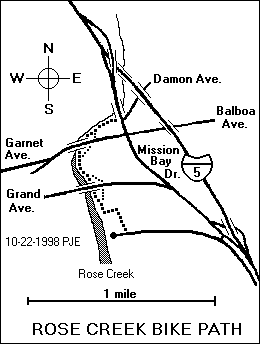
This popular path is an important part of the inland route between Mission Bay and UCSD, and the south end of it is on the most popular route around Mission Bay. The name "Rose Creek Bike Path" is official, and appears on some signs.
The path begins near the west end of N. Mission Bay Drive (Thomas 1248 C6, N 32 47.913 W 117 13.171). (See photograph.) It runs through a narrow fenced corridor among a boatyard, a golf course and an athletic field. It turns north and runs along the east bank of Rose Creek and emerges on Mission Bay Drive at the intersection of Damon Ave. (Thomas 1248 C4, N 32 48.450 W 117 13.171).
The path passes under Grand Avenue and Garnet Avenue. (See photograph of path running under Garnet Avenue.) There is access to the path from both sides of both streets.
There is also good access to the east ends of Figueroa Blvd., Magnolia Ave., and Hornblend St.
All of this path qualifies as a red route, although the RideLink map shows the part south of Grand Avenue in yellow ink, probably because it is narrow and rough and may not meet the minimum standards for an official bike path.
The Mike Gotch Bridge Memorial Bike Path might be considered an extension of this path.
Last explored: 4-3-2012
This path, which formally opened on April 20, 2012, begins at the west end of N. Mission Bay Dr., near the southern end of the Rose Creek Bike Path (Thomas 1248 C6, N 32 47.896 W 117 13.186). It runs due west across Rose Creek and ends at the entrance to Campland on the Bay (N 32 47.823 W 117 13.531). See photograph.
Bicyclists can continue west for another 0.15 miles along the access road to the junction of Pacific Beach Dr. and Olney St.
This path is a long-awaited and much-needed link in the recreational bike route around Mission Bay. There is no longer any need to ride on Grand Ave.
The bridge over Rose Creek is named for the late Mike Gotch, a former San Diego city councilman who was instrumental in the recreational development of the Mission Bay area.
Last explored: 4-20-2012
With a speed limit of eight miles per hour and lots of competition from pedestrians and roller skaters, this path isn't fast, but it is scenic. Its formal name is Ocean Front Walk, but everyone calls it the Boardwalk.
The path begins at a parking lot just west of the south end of Mission Boulevard (Thomas 1267 J4, N 32 45.593 W 117 15.078).
It runs north along the beach and ends at the west end of Law Street in Pacific Beach (Thomas 1247 H5, N 32 48.105 W 117 15.538).
See photograph.
The part through Mission Beach is straight and level, and it even has a yellow line down the middle. Farther north it meanders a little bit near parking areas.
There is easy access to the west ends of streets and alleys along the way. In Mission Beach, there are street signs on most of them.
The best routes from this path to the North Bayside Walk are El Carmel Place, Santa Clara Place and San Jose Place. There are traffic lights or four-way stop signs where these streets cross Mission Blvd.
The part between Ventura Place and Pacific Beach Drive has been widened. There were formerly separate parts of the path for pedestrians and wheeled traffic (bicycles, roller skates and skateboards). See photograph. However, the tactic failed, so the path was restriped with only two lanes, one northbound and the other southbound.
Last explored: 5-1-2012
This bike path begins on the west side of Friars Road, 0.13 miles south of Sea World Drive (Thomas 1268 E4, N 32 45.737 W 117 12.462), and proceeds due west along the north bank of the San Diego River all the way to the jetty separating the San Diego River from Mission Bay Channel (Thomas 1267 J4). It comes to an end at a locked gate 0.18 miles out on the jetty (N 32 45.447 W 117 14.842).
The path passes under the Sports Arena Blvd. and Sunset Cliffs Blvd. bridges.
Technically, the part between Friars Road and the Sports Arena Blvd. bridge is not a red route, because motor vehicles can enter it from Sea World Drive at one place (the intersection of South Shores Park). But there are usually very few motor vehicles on it.
There are paths leading directly up to walkways on both sides of the Sports Arena Blvd. bridge and the Sunset Cliffs Blvd. bridge. The walkways on the Sports Arena Blvd. bridge and the east side of the Sunset Cliffs Blvd. bridge are very narrow. The bike path on the west side of the Sunset Cliffs Blvd. bridge is a much better route over the San Diego River.
Just west of the Sunset Cliffs Blvd. bridge, a side path veers to the north and emerges on Quivira Road.
The westernmost part is technically not a red route because part of it is also used for motor vehicle access to a small parking area at the entrance to the jetty.
Last explored: 7-12-2008
The bike path on the Sunset Cliffs Blvd. bridge (Thomas 1268 B4) over the San Diego River is undoubtedly the best shared bridge crossing in San Diego County. The bike path is separated from the traffic lanes by a barrier big enough to stop a tank, it is wide enough for bicycles to pass one another, and there is a separate sidewalk for pedestrians.
The path begins on Quivira Road (N 32 45.588 W 117 14.001) and runs along the west side the bridge. At the south end, there is a junction with the Ocean Beach Bike Path (N 32 45.379 W 117 14.128).
There is also a pedestrian and bike path on the east side of the bridge, but it is quite narrow and hard to negotiate with a bicycle. Bicyclists approaching the bridge from the south should use a small part of the Ocean Beach Bike Path to pass under the bridge and onto this path.
A proposed extension of this path along Sunset Cliffs Blvd. into Ocean Beach has fallen short. A concrete path along this route was opened about March 2005, but it goes only as far as a parking area for Robb Field. Bicyclists can reach the intersection of Sunset Cliffs Blvd. and W. Point Loma Blvd. only by crossing a grassy area, ascending a short, steep path to Sunset Blvd., and following an asphalt sidewalk to the intersection.
Last explored: 5-2-2012
This path begins at the west end of Hotel Circle Place, right next to the entrance to Sefton Park (Thomas 1268 G4, N 32 45.640 W 117 11.400) (see photograph). It runs along the south side of Sefton Park (see photograph) and continues west between Interstate 8 and the San Diego River, all the way to the ocean. The west end is between Ocean Beach Park and Dog Beach (Thomas 1267 J5, N 32 45.259 W 117 15.099).
Along the way, the path passes under Morena Blvd. and Pacific Highway. There are formal, signed entrances to the path on both sides of both streets.
The access ramp from the east side of Morena Blvd. is steep and has some sharp turns. Bicyclists are advised to dismount and walk. See photograph.
Unfortunately, there is a guardrail right across the entrance to the path from the east side of Pacific Highway. Bicyclists entering or leaving the path there have to make some sharp turns that wouldn't be necessary if the guardrail had been located with bicycle traffic in mind.
There are also formal, signed entrances to the path on both sides of the Sports Arena Blvd. and Sunset Cliffs Blvd. bridges.
There is also access to the Ocean Beach Athletic Area (Robb Field) (N 32 45.323 W 117 14.577), to Dog Beach, and to a parking area just south of Dog Beach.
Bicyclists must slow down to pass between bollards at two places 0.05 and 0.26 miles from the west end of the path.
The name "Ocean Beach Bike Path" is official and appears on signs in some places. The path is part of the San Diego River Trail, a planned but mostly unbuilt path along the San Diego River from the ocean to Lakeside and possibly farther upstream.
The newest portion, between Pacific Highway and Sefton Park, was dedicated on June 26, 2009. At that time it was signed as "Ocean Beach Bike Path to Hotel Circle N. Bikeway", but that unwieldy name probably will not stick because the sign did not appear to be permanent.
Last explored: 3-9-2012
This bike path begins on East Mission Bay Drive about halfway between the entrance to Fiesta Island and Sea World Drive (Thomas 1268 D3, N 32 46.053 W 117 12.568).
It runs west along the south shore of Mission Bay. Just before the path reaches the parking lot for the South Shores Boat Ramp, a side path turns left (south) and emerges on the north side of a road called South Shores Park. (Mission Bay Pkwy. in the Thomas Guide).
The path was closed for construction and was reopened on June 6, 2008 with the dedication of the South Shores Promenade, a walkway that runs parallel to this path between the path and the bay for 0.37 miles west of West Mission Bay Drive.
Last explored: 2-25-2011
This bike path begins on the northwest corner of the intersection of Sea World Drive and South Shores Park. An entrance to the Lower San Diego River Bike Path lies to the south of this intersection. There is a traffic light with a pedestrian signal that bicyclists can use to cross Sea World Drive safely.
The path runs along the south side of South Shores Park. Near the parking lot for South Shores Boat Ramp, it turns south and runs right next to Sea World Drive and Perez Cove Way.
In three places, pavement markings direct pedestrians onto a separate parallel path next to the Sea World parking lots.
At one place, the path turns left and crosses Perez Cove Way at a marked crosswalk with a button-activated traffic light.
The path then runs along the other side of Perez Cove Way and ends at the southeast corner of its intersection with Ingraham Street (Thomas 1268 B3, N 32 46.064 W 117 14.004).
The path is lined in some places with Torrey Pine trees of various sizes. The Torrey Pine is a rare species that grows naturally only at Torrey Pines Reserve and on one offshore island. However, Torrey Pine trees have been planted at other places.
Last explored: 3-21-2012
A frontage road runs along the west side of Catalina Blvd. between Talbot Street (Thomas 1287 J2) and a point about a hundred feet south of Garden Lane (Thomas 1287 J4). The official north-south bike route runs along it, although many bicyclists prefer to ride on the main part of Catalina Blvd.
From the south end of the frontage road (N 32 42.798 W 117 14.892), a true red route runs along the west side of Catalina Blvd. as far as the intersection with Electron Drive (N 32 42.602 W 117 14.943), a distance of 0.22 miles. It is actually an extra-wide sidewalk, but signs at both ends mark it as a bike route.
Like most sidewalks, it has seams between concrete blocks, but one of them is especially large. Watch out for it, especially if you are riding downhill (north).
A sign on Catalina Blvd. at the intersection of Electron Drive directs northbound bicyclists to cross the street and enter this path, but most northbound bicyclists prefer to stay on Catalina Blvd. The frontage road and path are used more often by southbound bicyclists.
This path is not shown on the RideLink map.
Last explored: 3-20-2012
This little path is really a north entrance to Bill Cleator Community Park. It begins at the southwest end of Soto Street, just one block from Valeta Street (Thomas 1268 B5) and ends at the north end of the park access road (Thomas 1268 B6).
Bicyclists can follow the access road roughly south another 0.25 miles to the park entrance on Famosa Blvd.
Part of this path is shown on the RideLink map.
Last explored: 1-14-2005
Like the Boardwalk, this path has a speed limit of only eight miles per hour and bicyclists face competition from pedestrians and roller skaters, but it usually isn't as crowded as the Boardwalk. The official name of this path is "Bayside Walk".
This path begins on the north side of West Mission Bay Drive, just west of the Bahia Hotel (Thomas 1267 J2, N 32 46.330 W 117 14.922). It runs north along the western shore of Mission Bay, past the Catamaran Hotel, and all the way around Sail Bay.
The path goes under the Ingraham Street bridge and emerges in a parking lot on the south side of Corona Oriente Road about 0.2 miles southwest of the intersection of Crown Point Drive and Lamont Street (Thomas 1248 B7, N 32 47.322 W 117 13.966).
There is easy access to the east and south ends of streets and alleys along the way. There are also stairways from the bike path to both sides of Ingraham Street.
The best routes from this path to the the Boardwalk are El Carmel Place, Santa Clara Place and San Jose Place. There are traffic lights or four-way stop signs where these streets cross Mission Blvd.
Last explored: 5-1-2012
Like the Boardwalk, this path has a speed limit of only eight miles per hour and bicyclists face competition from pedestrians and roller skaters, but it usually isn't as crowded as the Boardwalk. The official name of this path is "Bayside Walk".
The path begins on the south side of West Mission Bay Drive, just west of the entrance to Mariner's point (Thomas 1267 J3, N 32 46.267 W 117 14.833). It runs south along the western shore of Mission Bay and ends on the north side of a road leading to a parking lot just east of the south end of Mission Blvd. (Thomas 1267 J4, N 32 45.600 W 117 14.877). A 0.5-mile branch of the path (not included in the mileage given above) goes around the parking lot and emerges on the south side of the same road.
Last explored: 5-1-2012
This route wasn't on the previous edition of the RideLink map, and most bicyclists prefer to ride on East Mission Bay Drive, which runs parallel to it. But it is open to bicycles, albeit with a ridiculously low speed limit of only eight miles per hour.
The path begins on the north side of Sea World Drive 0.05 miles west of the intersection with East Mission Bay Drive (Thomas 1268 D3, N 32 45.983 W 117 12.530). It runs north just west of East Mission Bay Drive, past the entrance to Fiesta Island (N 32 46.140 W 117 12.553).
After crossing Tecolote Creek (on a path separated from the traffic lanes by a sizable barrier), it turns west and follows the eastern shore of Mission Bay all the way to the entrance to De Anza Trailer Park at the south end of De Anza Rd. (Thomas 1248 D6, N 32 47.835 W 117 12.940).
About 0.13 miles south of the Mission Bay Visitor Information Center at East Mission Bay Drive and Clairemont Drive, the path passes a comfort station (N 32 47.311 W 117 12.538) with a rack containing brochures on organized bicycle, running, walking and multi-sport events.
Last explored: 7-12-2008
This little path, hardly more than a sidewalk, connects Tecolote Road to Knoxville Street. It begins on the west side of the access road to the San Diego Raquet and Tennis Club and emerges on the south side of Knoxville Street just east of Nashville Street (Thomas 1268 E2). It is not shown on the RideLink map.
Last explored: 2-9-2005
This popular bike path through Rose Canyon is both a scenic route and an important link between the Mission Bay area and the UCSD and UTC area. It is very popular with weekend bicyclists. The name "Rose Canyon Bike Path" is official and appears on some signs.
The path begins at the north end of Santa Fe Street (Thomas 1248 B1, N 32 50.049 W 117 13.934), and runs north just east of Interstate 5 and west of the Santa Fe Railroad and Rose Creek. It passes under interchange between Interstate 5 and Highway 52 (see photograph), and emerges at the south end of La Jolla Colony Drive just east of the interchange with Interstate 5 (Thomas 1228 A6, N 32 50.940 W 117 14.085) (see photograph).
There is a sign at the entrance to Marian Bear Park south of the interchange and east of the path. You'll have to cross both the railroad tracks and the creek to enter the park, but the path is fairly well beaten.
Near the northern end of the path, there is an unpaved path to the east which goes up Rose Canyon as far as Genesee Ave. It is suitable only for mountain bikes and hybrid bikes.
You may also see daredevil mountain bikers following a narrow, unpaved path clinging to the hillside east of the creek. This is part of a popular off-road route between Marian Bear Park and Rose Canyon.
Because this path runs alongside a railroad, it is listed in a publication of the Rails-to-Trails Conservancy.
Last explored: 3-7-2012
This is the only bike path in San Diego County, other than the Silver Strand bike path, that is built on an abandoned railroad right of way. An interurban passenger railway ran through here until about 1940. The path runs through what is officially called the "Fay Avenue Corridor", a southward extension of Fay Avenue. It is signed as "Fay Avenue Bike Path" at the north end, although it is not directly connected to Fay Avenue.
The path begins on the south side of Nautilus Street, just west of the intersection with Fay Avenue (Thomas 1247 F1, N 32 49.964 W 117 16.307). See photograph. It runs south above and through a residential area, and emerges on the north side of Via Del Norte about midway between La Jolla Hermosa Ave. and Beaumont Ave. (Thomas 1247 F2, N 32 49.406 W 117 16.459). See photograph of south end.
The official bike route turns east and runs south on Beaumont Ave. for three blocks.
However, the old railroad right of way continues south for 0.44 miles. Although much of it is unpaved, it is a well-beaten path firm enough to be ridden with care even on a road bike. See photograph. It emerges at the intersection of Camino de La Costa and La Jolla Hermosa Ave. (Thomas 1247 F3, N 32 49.067 W 117 16.253).
At a point 0.11 miles south of Beaumont Ave., there is an interpretive sign describing this path, and the southern continuation, as "La Jolla Bike Path".
The currently unpaved part of this path, which is 0.30 miles long, needs the asphalt treatment to make it into a charming path.
This path is listed in a publication of the Rails-to-Trails Conservancy.
This path is part of an inland bike route from Pacific Beach to the University of California at San Diego. Northbound bicyclists following this route should be aware of some signage problems at the north end of La Jolla Hermosa Ave. (Thomas 1247 F3). The bike route runs north on La Jolla Hermosa Ave., east on Camino de la Costa, north on Beaumont Ave., west on Via del Norte and north on the Fay Bike Path. The turn from La Jolla Hermosa Ave. is signed, but the arrow is somewhat obscure and formerly pointed in the wrong direction. The turn from Camino de la Costa to Beaumont Ave. is also signed, but the sign is often obscured by vegetation.
Last explored: 5-1-2012
This nine-foot-wide asphalt path runs along the east side of Regents Road from the intersection of Arriba St. (N 32 51.681 W 117 13.367) to the intersection of Berino Ct. (Thomas 1228 C4, N 32 51.826 W 117 13.329).
It's not clear whether it was intended to be a bike path. The surface is a little rough, but it's definitely ridable. And there is a separate four-foot-wide concrete sidewalk to the west of the path, right next to Regents Road.
Last explored: 4-3-2012
This path doesn't exist, and it probably never will. An older edition of the RideLink map showed it beginning on the west side of Regents Road just opposite Eastgate Mall (Thomas 1228 C2) and ending near the intersection of Voigt Dr. and Campus Point Dr. (Thomas 1228 C1). The current edition of the RideLink map shows no bike route of any kind along this route.
Last explored: c. 3-1-2007
There is already an unpaved path along this route, and it is used quite often by mountain bikers and pedestrians, despite a no-trespassing sign at the south end. There have been proposals to pave it.
The path begins as a paved driveway leading west and uphill from the south end of Roselle Street (Thomas 1208 C7).
The pavement disappears about 0.20 miles from the bottom and the path passes through a large cleared area.
At 0.43 and 0.69 miles from the bottom there are tiny streams of water flowing across dips in the path.
The path emerges on the north side of Eastgate Mall, 0.10 miles east of Genessee Ave. and 0.06 miles west of Easter Way (Thomas 1228 D2).
The opening of the Voigt-Roselle Bike Path on June 29, 2018 probably makes this proposal a dead issue.
Last explored: 6-16-2001
This path, which was formally opened on June 29, 2018, connects the University of California at San Diego with the Sorrento Valley.
It begins at the northeast corner of Voigt Drive and Greenhouse Lane (N 32 52.888 W 117 13.752), just west of the bridge carrying Voigt Drive over Interstate Highway 5. It runs north along the west side of Interstate Highway 5 and its access ramps, passing over Genesee Avenue on an impressive, but nameless, pedestrian and bicycle bridge. See photograph.
It ends on the south side of Roselle Street, just west of the onramp to southbound Interstate Highway 5 (N 32 54.103 W 117 13.500).
The path runs almost entirely downhill, with an elevation loss of approximately 300 feet.
There is access to both sides of Genesee Avenue, with a few circular concrete benches. See photograph of north side access point.
Last explored: 6-29-2018
This bike path runs along the south side of North Harbor Drive from Laurel Street (Thomas 1288 H1, N 32 43.636 W 117 10.820) to the west end of Spanish Landing Park (Thomas 1288 D1). It is well marked and quite popular with runners and bicyclists.
The path was shortened slightly during construction at San Diego International Airport. It used to cross Harbor Island Drive in front of the entrance to the Sheraton Harbor Island Marina Tower (N 32 43.629 W 117 11.804). It now stays much closer to North Harbor Drive. However, a portion of the old path on the west side of Harbor Island Drive is still open. It meets the main path (N 32 43.727 W 117 11.864) about 0.17 miles west of the intersection of North Harbor Drive and Harbor Island Drive.
When passing through Spanish Landing Park, the path goes through parking lots in a few places, but its meanders are clearly marked.
The path emerges on the south side of Harbor Drive just east of the bridge over the channel from San Diego Bay into the former Naval Training Center. If you are going west, and you want to cross Harbor Drive here, you can follow a hard-packed dirt path next to a roadway under the bridge. There is no direct access to the north side of Harbor Drive, but bicyclists can usually get through a small landscaped area.
By riding a short distance over hard-packed dirt, you can reach a smaller bridge north of Harbor Drive. This leads directly into a shopping center at Liberty Station, passing by the USS Recruit, a scaled-down ship use to train sailors when the area was part of the Naval Training Center.
Another path, the Esplanade Bike Path, begins here.
At the east end, you can ride 1.1 miles to Broadway Pier through parking lots and along broad sidewalks without venturing out into the traffic on North Harbor Drive. There are signs apparently directed to bicyclists or roller skaters a short distance southeast of Laurel Street where the sidewalk passes next to some rest rooms. The text on the signs is "CAUTION WATCH FOR PEDESTRIANS CROSSING SIDEWALK". The latest version of the RideLink map shows it as a red route.
Last explored: 3-9-2012
This path begins near the USS Recruit, a ship set into a permanent foundation next to N. Harbor Dr. just west of a channel from San Diego Bay into the old Naval Training Center (Thomas 1288 D1). The ship was formerly used to train sailors.
The path runs roughly north along the west side of the channel through NTC Park. It ends in a jumble of sidewalks at the junction of Truxton Rd., Lytton St. and Barnett Ave. (Thomas 1268 E6).
Side paths through the park to the junctions of Cushing Rd. with Roosevelt Rd. and Dewey Rd. are lined with approximately 50 monuments to US Navy submarines.
An unpaved pedestrian path runs between this path and the channel most of the way.
There is a connection between this path and the North Harbor Drive Bike Path that pedestrians and bicyclists can use to avoid having to cross N. Harbor Dr.
Last explored: 8-7-2012
Columbia Street in Downtown San Diego is discontinuous for motorists, but not for bicyclists. Starting at the intersection of Columbia Street and G Street (Thomas 1289 A3, N 32 42.756 W 117 10.051) and proceeding due north through Pantoja Park to the intersection of Columbia Street and Broadway (N 32 42.934 W 117 10.078) is a bicycle and pedestrian path.
A side path runs 0.04 miles due east to the intersection of State Street and E Street.
Last explored: 5-1-2012
This path begins on the south side of Broadway just west of the railroad tracks (Thomas 1288 J3, N 32 42.940 W 117 10.204) and runs south along the west side of the tracks past the end of C Street. The tracks veer east, but the path continues approximately due south, crosses F Street and G Street, and ends on the north side of Harbor Drive (N 32 42.703 W 117 10.202). The southern part resembles a pedestrian mall more than a bike path. Beveled curbs make the street crossings fairly smooth.
Part of this path might be considered a northward extension of the nearby Martin Luther King Jr. Promenade. It is so considered in the official Rails-to-Trails Conservancy guidebook.
Last explored: 5-1-2012
This bike path begins on the south side of the entrance to Broadway Pier in Downtown San Diego (Thomas 1288 J3).
It runs south along the west side of Harbor Drive, and ends at the southwest corner of Harbor Drive and Pacific Highway.
Along the way it passes near the Aircraft Carrier Memorial, a black obelisk bearing the names of all U.S. aircraft carriers.
Parts of the path are paved with something resembling cobblestones. Bicyclists who want to avoid being shaken must ride very near the edge of the path.
On 4-3-2012, the southeastern part of this path was disrupted by construction.
Last explored: 4-3-2012
This bike path begins at the southeast corner of Kettner Blvd. and G Street (Thomas 1288 J3, N 32 42.750 W 117 10.157). It runs southeast between the trolley tracks and Harbor Drive, and ends at the junction of Harbor Dr. and Park Blvd. (Thomas 1289 B4, N 32 42.315 W 117 9.455).
The part north of Fifth Ave. sports an unusual two-tone paint job. Half of the path is painted pale blue, and the other half is painted pale green.
The part south of Fifth Ave. is plain asphalt and runs closer to Harbor Dr.
There are no bike path signs on this path, but the word "bicycle" appears on signs at some street crossings.
A second, but less colorful path runs along the other side of the trolley tracks from the trolley station on Imperial Ave. to Market Street. The path gets a little vague as it passes through the Gaslamp Quarter Trolley Station on Fifth Ave. It is identified as the "MLK Promenade" only by signs prohibiting pedicabs.
Part of this path was used as an alternate route for bicyclists while the bike lanes on Harbor Drive were closed by construction near the Convention Center.
Because this path runs along a railroad right of way, it is listed in a publication of the Rails-to-Trails Conservancy.
Last explored: 5-1-2012
This little path begins at the northwest end of Newton Ave. (N 32 42.255 W 117 9.136) and runs due north to the intersection of Commercial St. and S. 13th St. (Thomas 1289 B4, N 32 42.280 W 117 9.147). It is shown erroneously on the 2009 Thomas Guide as part of S. 13th St. (See photograph.)
Last explored: 5-1-2012
This path is part of the Bayshore Bikeway, and the name is tentative.
The path runs along the northeast side of S. Harbor Dr. from the junction with 32nd St., (N 32 41.148 W 117 7.513) near the Pacific Fleet Trolley Station (hence the name) to an undistinguished point about 0.55 miles to the southeast, near the San Diego/National City city limit (N 32 41.148 W 117 7.513). It will eventually be extended in both directions.
Bicyclists riding northwest on S. Harbor Dr. can use the full path.
Bicyclists riding southeast have to cross S. Harbor Dr. at the intersection with 32nd St. to join the path. Then in order to cross again, they must leave the path at a traffic light 0.10 miles short of the end of the path (N 32 40.891 W 117 7.154), which is visible in the photograph of the end. The southeast-bound lane of the bike path is fenced off beyond this point.
Last explored: 09-23-2015
This path has apparently been in existence for many years, but it wasn't shown on the previous edition of the RideLink map as a red route, and I didn't know it was there until recently (9-6-1999). It connects two parts of Upas St. in Balboa Park that appear to be completely separate on most maps.
The path begins at the corner of Upas St. and Seventh Ave. (Thomas 1269 B6, N 32 44.458 W 117 9.497), near the northwest corner of Balboa Park.
It runs roughly east for 0.08 miles and then turns left and descends steeply into a canyon. There is a bicycle parking rack near the turn.
About 0.05 miles down the side of the canyon, the path makes a very sharp right turn. Most bicyclists will have to dismount to negotiate this turn safely.
Near the bottom of the canyon, an unpaved running trail branches off to the right and continues south through the canyon. The bike path swerves left and crosses Highway 163 on a pedestrian bridge built in 1946.
On the other side of Highway 163, the path ascends, descends and ascends again to emerge at the entrance to the Boy Scout Service Center at 1207 Upas St., on the south side Upas St. near the corner of Upas St. and Vermont St. (N 32 44.466 W 117 9.191).
This path is a very convenient link between the east and west sides of Balboa Park, but it is not a good ride because of its steep grades and sharp turns.
The bridge carrying this path is not the closed onramp from southbound Richmond St. to southbound Highway 163. That bridge is still passible, but it is of limited use to bicyclists, even mountain bikers, because access to the jogging path along the west side of Highway 163 is blocked by a fence. On 9-6-1999 there was a hole in the fence large enough to carry a mountain bike through, but holes in fences sometimes get repaired. Bicycles are NOT allowed on Highway 163!
There is also a connection of sorts on the Upas St. corridor between Florida St. and Alabama St. (Thomas 1269 C6). However, it is merely a very steep sidewalk, which most bicyclists wouldn't want to ride in either direction.
Last explored: 5-14-2012
This bike path is an important link in the Interstate 15 corridor.
The path begins at the north end of Erma Road in Mira Mesa (Thomas 1209 F2), and runs north along the east side of Interstate 15, passing within spitting distance of it as both go through a road cut. Ride this part with care, because small rocks often fall onto the path from the hillside to the east.
The path crosses Scripps Poway Parkway just east of the Mercy Rd. and Scripps Poway Pkwy. interchange on Interstate 15. There is a traffic light with a pedestrian crossing signal that bicyclists can use. However, traffic leaving northbound Interstate 15 and turning right onto eastbound Scripps Poway Parkway often fails to yield to bicyclists and pedestrians; there have been many complaints about this intersection.
The path continues north along the east side of Interstate 15 and descends into Los Peñasquitos Canyon. For most of the first 0.20 miles, it runs next Cara Way, which is the access road for the Peñasquitos Pump Station.
Bicyclists who have extra time and energy may want to take a side trip down to the pump station (and back up again). The pump station itself is uninteresting, but some of the murals cut into the retaining walls next to the access road may be of interest to those who like Kumeyaay art. A plaque near one of the murals describes the work as "Rock of Aegis, a project whose intent is to reconcile the present with the knowledge and wisdom of the past. Petrographs by the Kumeyaay, original inhabitants of this land, are the inspiration for these symbols. Commissioned for the Peñasquitos Pump Station." Across from the murals is a small parklike area identified by a legend on a concrete bench as the San Diego Crime Victims Oak Garden.
At the bottom of the canyon, the path crosses Los Peñasquitos Canyon Creek on an old highway bridge, while Interstate 15 crosses it in on a newer, much higher bridge called the Knott Memorial Bridge. See photograph.
The bridge was named after the late Cara Knott, who was found dead under the bridge in 1986. A highway patrol officer was convicted of her murder. I have rather arbitrarily applied the name to the bike path, too. The path apparently has no official name and is commonly referred to by the names of nearby streets and highways. One sign formerly referred to it as the "I-5 Bike Path", which was an obvious mistake. The sign has been amended to read "I-15 Bike Path".
Just north of the bridge is a concrete retaining wall with a picture of four bicyclists embossed into it. Their bicycles were originally painted blue, red, green and white. However, they have since been repainted a neutral gray to cover up grafitti.
The path then turns eastward and ascends toward Poway Road, emerging on the south side of Poway Road at a point about midway between Interstate 15 and Sabre Springs Road (Thomas 1189 G6).
When it reaches Poway Road, the path turns east and runs next to the south side of Poway Road to the intersection with Sabre Springs Pkwy. (Thomas 1189 H6, N 32 56.811 W 117 5.763).
NOTE: The part next to Poway Road was added recently and has not yet been included in the measured length of the path.
Last explored: 06-04-2015
This path begins on the north side of Poway Road 0.10 miles east of Creekview Drive (Thomas 1189 J6). There is no curb cut, so bicyclists riding on Poway Road will have to dismount to enter the path.
It runs north and west around the edge of Savannah Terrace, which is a new residential community.
It ends on the west side of Sabre Springs Parkway, just north of Savannah Creek Drive (Thomas 1189 H5).
This path is shown in the 2006 Thomas Guide as a faint dotted line.
Last explored: 10-2-2005
This path begins at the corner of Wickerbay Cove and Meadow Grass Lane in Sabre Springs (Thomas 1190 A6). It runs east along the south edge of South Creek Neighborhood Park and ends on the west side of Springhurst Drive just 0.07 miles south of Bridgewood Way.
Last explored: 2-3-2003
Alemania Road has been extended a short distance (0.04 miles) north of Mercy Road, although the extension is not shown on the 2003 Thomas Guide (Thomas 1189 F7). This path begins at the north end of Alemania Rd. and ends between two houses at the southeasternmost part of Kika Court.
At the north end, the path passes through a gate, which has a latch but no lock.
This path is apparently used by residents of the Allegra development to reach a few businesses at the corner of Alemania Rd. and Mercy Rd. Most of the streets of the development appear to be private, although access to them is not blocked by gates or guardhouses.
An old, faded highway sign near the north end of this path suggests that it was a highway alignment partly obliterated when Interstate Highway 15 was built or widened.
Last explored: 12-08-2013
This bike path begins on the southwest side of Rancho Peñasquitos Blvd. right next to the exit from eastbound State Highway 56 (Thomas 1189 F4, N 32 57.465 W 117 06.748), and opposite Azuaga Street.
It runs next to State Highway 56 on the south side all the way to the Carmel Valley, where it joins the Carmel Valley Creek Bike Path near the east end of the Carmel Valley Creek Bike Path (Thomas 1188 E6, N 32 56.914 W 117 12.157). See photograph taken from West Ted Williams Bike Path or photograph taken from Carmel Valley Creek Bike Path.
There is no access to the path from adjacent residential areas. The path runs under Salmon River Road, Carmel Mountain Road, and Santa Fe Farms Road with access to all roads along paved side paths. See photograph. There are no freeway interchanges with these roads.
The path crosses Black Mountain Road at grade level next to an interchange. Bicyclists must use a pedestrian crossing signal. Unfortunately, crossing in strict obedience to the signal usually requires two cycles. Fortunately, most bicyclists (and fast-moving pedestrians) can complete the entire crossing in one cycle, if traffic in both directions is stopped. WARNING: Motorists leaving the freeway often turn into the crosswalk without yielding to pedestrians and bicyclists.
The path crosses Camino Del Sur (formerly Camino Ruiz) at grade level next to an interchange. Bicyclists must use a pedestrian crossing signal. (The 2004 Thomas Guide still uses the name Camino Ruiz, although highway signs use the name Camino Del Sur.)
The path crosses Carmel Valley Road at grade level next to an interchange. Bicyclists must use a pedestrian crossing signal.
State Highway 56 is also called Ted Williams Parkway or Ted Williams Freeway.
On some official signs, this path has been called the Highway 56 Bike Path or the SR-56 Bike Path.
The Carmel Valley Creek Bike Path, this path, Azuaga Street and the East Ted Williams Bike Path together constitute a bike route along the State Highway 56 corridor.
There are several planned or proposed enhancements to this path:
Last explored: 4-8-2005
This bike path begins at the east end of Azuaga Street in Rancho Peñasquitos (Thomas 1189 G4, N 32 57.718 W 117 06.132). (See photograph.) It runs parallel to State Highway 56 and ends on the west side of Sabre Springs Parkway just south of the exit ramp from eastbound Ted Williams Parkway. (Thomas 1189 H3, N 32 57.867 W 117 05.432). (See photograph.)
Where State Highway 56 crosses Interstate Highway 15, there is an interchange. The path crosses the entrance ramp to southbound Interstate Highway 15 on the west side and a combined entrance and exit ramp to northbound Interstate Highway 15 on the east side. Both crossings have marked crosswalks with pedestrian signals. In both crossings, right-turning vehicles may be a problem for bicyclists.
There is no crosswalk where the path meets Sabre Springs Parkway. Bicyclists who want to cross Sabre Springs Parkway (to go north or to continue east on Ted Williams Parkway) must first cross the offramp and then cross Sabre Springs Parkway north of the ramp.
Eastbound bicyclists might avoid these maneuvers by leaving the path and riding on the exit ramp, joining the appropriate lane to turn left or go straight ahead into the entrance ramp on the other side. No signs forbid this, and it is probably legal because this part of the road technically isn't a freeway. However, it would be quite dangerous unless automobile traffic is light.
Bicyclists going west on Ted Williams Parkway are required to exit at Sabre Springs Pkwy/Rancho Carmel Dr, turn left at the end of the ramp, pass under Ted Williams Parkway and turn right into the path.
On some official signs and documents, this path has been called the Highway 56 Bike Path or the SR-56 Bike Path.
This path reopened on May 15, 2008, nearly two years after the planned completion date.
Last explored: 3-30-2012
This six-foot-wide concrete path begins on the south side of Azuaga Street in Rancho Peñasquitos, just 0.08 miles west of Caminito Ciera (Thomas 1189 G4, N 32 57.652 W 117 06.279). It goes around the edge of the gated Sun Ridge community, passes by Sun Ridge Vista Mini Park, and emerges on the west side of Avenida Grande. Bicyclists can continue south about 0.10 miles to a locked gate just 0.06 miles north of the intersection with Avenida de la Cantina (N 32 57.483 W 117 06.318). There is just enough room to ride around the gate.
The length of 0.22 miles includes the part of Avenida Grande north of the gate, because it not open to regular vehicle traffic.
This path was apparently built for access to Sun Ridge Vista Mini Park, but it makes a good shortcut if you're going this way. There are no rest rooms or other services at the park, but there is a small playground.
Last explored: 3-30-2012
This path is a bicycle and pedestrian bridge over Interstate 805 that bicyclists can use to avoid the nearby Balboa Avenue interchange, which is difficult and hazardous for bicyclists.
It begins on the east side of Antiem St. opposite Batista St. and ends at the corner of Othello Ave. and Kirkcaldy Dr. (Thomas 1249 A3).
Although the ramps on both sides are narrow and steep and have sharp turns, the path is ridable. There are curb cuts at both ends.
Last explored: 3-5-2009
This bike path begins on the north side of Balboa Ave. just west of the Interstate 805 interchange (Thomas 1248 J2 N 32 49.278 W 117 9.923). It runs north through a fenced area just west of Interstate 805 and emerges on Cannington Drive 0.07 miles south of Liebel Court (Thomas 1248 J1 N 32 49.781 W 117 10.065).
There is no access to adjacent residential areas from the bike path.
A sidewalk about nine feet wide runs 0.32 miles along the east side of Cannington Drive from this point to the intersection with Mount Abernathy Ave. If this sidewalk were in Escondido, it would probably be called a bike path.
Bicyclists traveling east on Balboa Ave. cannot turn left into this path. They should turn left at Charger Blvd., where there is a traffic light, and then ride 0.10 miles on the sidewalk on the north side of Balboa Ave. Similarly, bicyclists emerging from the south end of the path cannot turn left onto Balboa Ave. They should ride west to Charger Blvd. and cross there.
Last explored: 6-12-2019
This bike path begins on the north side of Clairemont Mesa Blvd. just west of the Interstate 805 interchange (Thomas 1248 J1 N 32 50.049 W 117 10.346), and right next to a Motel 6. It runs north through a fenced area just west of Interstate 805, then veers west and enters Mac Dowell Neighborhood Park. It ends on the east side of Arvinels Avenue at the south end of the park, about midway between Lehrer Dr. and Winthrop St. (N 32 50.338 W 117 10.505).
There is no access to adjacent residential areas from the bike path.
Bicyclists traveling east on Clairemont Mesa Blvd. cannot turn left into this path. They should turn left at Doliva Dr., where there is a traffic light, and then ride 0.19 miles on the sidewalk or through parking lots on the north side of Clairemont Mesa Blvd. Similarly, bicyclists emerging from the south end of the path cannot turn left onto Clairemont Mesa Blvd. They should ride west to Doliva Dr. and cross there.
MacDowell Neighborhood Park has drinking fountains, but no rest rooms.
In a few places near the south end of the path, the pavement is covered with dirt. Much of the pavement is in poor condition.
Last explored: 6-12-2019
This little path begins on the south side of Bergen St. just a short distance west of Mable Way (Thomas 1228 J7 N 32 50.110 W 117 10.354). It runs between fenced backyards and then south through a parking lot to emerge on Clairemont Mesa Blvd. right next to the MacDowell bike path described above (Thomas 1248 J1 N 32 50.051 W 117 10.345).
It is a five-foot-wide concrete path that looks more like a sidewalk than a bike path, especially at the south end. It has two right-angle turns that make it a poor ride. At the north end, there is a defaced bike path sign, but no curb cut.
Last explored: 6-12-2019
When the northern part of Sorrento Valley Road was closed to all traffic during construction on the interchange between Highway 56 and Interstate 5, bicyclists commuting between north coastal areas and the industrial parks of Sorrento Valley lost an important link. The alternate route via El Camino Real is one mile longer than the direct route, and it has a significant hill.
Then on February 11, 1998, the road was reopened to pedestrians and bicyclists, but not motor vehicles, so it's now a red route. This was largely due to persistent needling by bicyclists. On March 28, 2001, the San Diego City Council voted to keep it closed to motor vehicles.
The path begins at some temporary barriers on Sorrento Valley Blvd., 0.1 mile north of the intersection with Carmel Mountain Road (Thomas 1208 A3). It ends at other, more permanent, barriers 0.14 mile south of Carmel Valley Road, just south of the entrance to a Park and Ride lot (Thomas 1207 J1, N 32 55.818 W 117 14.486).
The southernmost 0.3 mile of the path is apparently also an access road for the San Diego Metropolitan Waste Water Department's Pump Station 65, "home of the world's best wastewater treatment experts".
The lagoon and marsh west of the path are part of Torrey Pines Reserve. Click here for a photograph.
Until 2007, the path was unpaved near the northern end where it passes under some freeway ramps. In late 2007, this portion was paved.
The rest of the path is essentially a two-lane paved highway.
Last explored: 5-13-2008
This bike path just south of Carmel Valley Creek has a delightful rural ambience because it runs next to ranches, not ranch houses. It is also known as the CVREP (Carmel Valley Restoration and Enhancement Project) Path. A 1.12-mile section on the east, which runs through Palacio Del Mar, has been opened to the public.
The path begins nowhere and ends nowhere, but it goes through some real places in between. For that reason, it is not described in the traditional end-to-end order.
There is an entrance to the path on the west side of Carmel Country Road, 0.10 mile south of the exit from eastbound Highway 56 (Thomas 1188 C7). There is no path sign on it, but the path is easy to find.
The eastern branch of the path runs north and east, under Carmel Country Road. On the other side of Carmel Country Road, it crosses Carmel Valley Creek on a small causeway. (See photograph.) If the causeway is flooded, bicyclists can cross Carmel Country Road and enter it from a side path on the north side of the creek and the east side of the road.
The eastern branch then runs approximately east along the north side of Ruette de Mer, a private street that is not open to the public.
It veers away from Ruette de Mer and then runs parallel to an unmarked but roughly paved street and south of it. Where it approaches the street, there used to be a small pedestrian gate that bicyclists could use to get access to the street. At this point (N 32 56.914 W 117 12.157) there is now a formal connection to the West Ted Williams Bike Path. See photograph.
The street formerly ran west to join Carmel Valley Road where it became the Highway 56 freeway, but this part has been obliterated by construction on the freeway. It now runs under the freeway and up to the south end of the remaining part of Old Carmel Valley Rd. There are bollards at the end of Old Carmel Valley Rd. which prevent automobile access, but bicyclists can pass between them easily. The West Ted Williams Bike Path runs steeply uphill to Highway 56. It then runs east along the south side of Highway 56.
The Carmel Valley Creek Bike Path itself comes to an abrupt end 0.27 miles east of the path junction (Thomas 1188 E6). There is no outlet -- the way is barred by fences and thickets. A bicyclist who reaches this point must turn around.
The west branch of the path runs south and then east. It passes under Carmel Creek Road and El Camino Real and then comes to an abrupt end near the northbound lanes of Interstate 5 (Thomas 1207 J2). A bicyclist who reaches this end doesn't necessarily have to turn around. Intrepid mountain bikers can follow crude trails under Interstate 5 to the Park and Ride lot on the other side, at least in the dry season.
There is formal, signed access to this path from the east side of Carmel Creek Road and the west side of El Camino Real (N 32 55.922 W 117 14.189).
There is also informal access from the east side of El Camino Real along a short, unpaved track that is easy to find from the bike path. It may not be so easy to see from El Camino Real. NOTE: In December 2015, this track was paved and, presumably, signed.
There is an unpaved equestrian path right next to this path from Carmel Country Road almost all the way to El Camino Real.
A westward extension under Interstate 5 to Sorrento Valley Road has been considered but is problematical because the bridge carrying Interstate 5 over Carmel Valley Creek is quite low.
A photograph taken along the path shows both the bike path and the equestrian path.
The part of this path west of Carmel Country Road is part of the San Diego Trans County Trail, which when completed will run from the Pacific Ocean to the county line east of Borrego Sprints.
Planned development along the path between Carmel Country Road and Carmel Creek Road may eventually destroy the rural ambience of this part.
Last explored: 3-30-2012, some updates 12-30-2015
This little path, like so many in the Carmel Valley area, is more like a sidewalk. This one has some sharp meanders that make it much more suitable for walking than cycling (see photograph).
It begins on north side of Carmel Knolls Drive opposite Almondwood Way. (Thomas 1188 D6) It runs north and then south, touching the end of nearly every cul-de-sac along the way, ending on the north side of Carmel Knolls Drive near Seabreeze Farms Dr. (See photograph).
There are no curb cuts where the path meets adjacent streets (see photograph). Bicyclists who want to follow the path have to ride on the sidewalk and make some sharp turns.
The path meets Sandshore Ct., Bradshaw Ct., Jordan Ridge Ct., Chandon Ct. and Vail Creek Ct. There are short side paths to Pacific Grove Pl. and Southhampton Cove. The path to Pacific Grove Pl. is described below as another bike path.
Last explored: 4-1-2007
This bike path begins as a side path from the Almondwood Bike Path to Pacific Grove Pl. It touches the end of Pacific Grove Pl. and then turns north touching the ends of Sanddolar Ct., Sandhill Ter., and Beachcomber Ct., and emerging on the south side of Pearlman Way.
The path, like the Almondwood Bike Path, has no curb cuts where it meets adjacent streets, and it has some sharp meanders.
Last explored: 4-1-2007
This bike path is a narrow asphalt path running mainly between fenced backyards. See photograph.
The path begins on the north side of Valley Centre Drive, 0.04 miles east of Carmel Vista Road (Thomas 1188 A7). It runs north for 0.16 miles, and then splits into two branches.
The east branch runs east for 0.14 miles and emerges on the west side of Carmel View Road 0.15 miles south of Carmel Grove Road (Thomas 1188 A7). (The east branch is not included in the total length of 0.82 miles.)
The west branch runs 0.06 miles east, 0.10 miles north, 0.10 miles east and 0.14 miles north to cross Carmel View Road just east of El Ruette Alliante. The crossing features curb cuts, bollards, and stop signs on the bike path.
It continues north of Carmel View Road, passes through Carmel Pointe, and ends at Carmel Valley Community Park (Thomas 1188 A6).
Last explored: 7-13-2004
This bike path begins on the south side of Del Mar Trails Road between Camarero Court and Montellano Terrace (Thomas 1188 B6). It runs south through a greenbelt and a small park and emerges on the north side of Carmel Park Drive just west of San Gregorio Way.
There are side paths leading to the ends of cul-de-sacs along the way.
Last explored: 2-10-2002
This bike path isn't finished yet. You'll need a mountain bike to negotiate the unpaved part (which has remained unpaved since November 1998). However, the view from this part of the path is quite impressive (see photograph).
The path begins at the northernmost parking lot in Torrey Highlands Park (Thomas 1188 B4), and runs south through the park to Del Mar Heights Road, following some power lines.
It continues on the south side of Del Mar Heights Road and runs south to Graydon Road.
On the other side of Graydon Road, the path continues, but the paved portion comes to an abrupt end after just 0.16 mile. A dirt track off to the left a short distance before the end of the pavement continues all the way down to the north end of Carmel Mission Park. Partially completed paths leading to the ends of cul-de-sacs on either side indicate that this is probably the route for a future path through a greenbelt. When it's finished, it should resemble the Carmel Del Mar School and Park path.
The path meanders through Carmel Mission Park and ends on the north side of Carmel Country Road west of Carmel Mission Road (Thomas 1188 B6, N 32 56.770 W 117 13.293).
There are some dirt tracks following the power lines from the south end of Carmel Mission Park as far south as Highway 56. They are barely ridable in some places, even on a mountain bike. I do not know whether this part will ever become a regular bike path.
Bicyclists who want to follow this path across Del Mar Heights Road will have to ride to the nearby intersection with Lansdale Drive and cross there.
There are no curb cuts where this path crosses Del Mar Heights Road and Graydon Road, although bike path signs have been installed at these two crossings.
Last explored: 02-10-2013
This path begins on the east side of Lansdale Drive, just north of Del Mar Heights Road (Thomas 1188 B5) (see photograph). It runs east through a shaded area and ends at the intersection of Callcott Way and Dunham Way (Thomas 1188 B6). There is formal access to the path from the south ends of Exbury Court and Brixton Place.
Last explored: 6-15-2002
This bike path begins on the south side of Del Mar Heights Road, just east of High Bluff Drive (Thomas 1187 J6). It runs south between an industrial area along High Bluff Drive and an undeveloped area along El Camino Real. The views to the east are quite good, and there are benches along the path.
The path emerges on west side of El Camino Real 0.05 mile north of High Bluff Drive (Thomas 1187 J7).
Last explored: 11-4-2000
This bike path begins on the east side of High Bluff Drive opposite Lady Hill Road (Thomas 1187 J5) and ends on the west side of Long Run Drive opposite Quarter Mile Drive (Thomas 1188 A5).
A short branch runs south to the Solana Highlands School parking lot, and an even shorter branch runs north to Overpark Road.
Last explored: 8-20-1997
This little path begins on the southwest side of Carmel Center Road, about midway between Corte de la Fonda and Futura Street (Thomas 1188 B6), runs approximately due south and ends on the north side of Carmel Country Rd. Side paths lead to the ends of Paseo Montanas and Corte de la Siena. The path runs right next to the west end of Mistral Place.
Last explored: 8-20-1997
This little path begins at the south end of Stratford Court in Del Mar (Thomas 1187 G7, N 32 56.640 W 117 15.654), runs approximately south, and emerges on the west side of Camino del Mar 0.22 miles north of Carmel Valley Road (N 32 56.610 W 117 15.633). It is little more than a sidewalk, but it does have bike route signs at both ends, and there is a bike route sign on Stratford Court about a half block north of the south end.
Bicyclists traveling south on coast route who know the Del Mar area well can avoid the traffic on Camino Del Mar by riding along residential streets and alleys and using this path to return to Camino del Mar.
Last explored: 3-30-2012
This path runs along the east side of Coast Highway 101 in Solana Beach, starting at Via De La Valle (Thomas 1187 F2) and running as far north as Ocean Street (Thomas 1167 E6). It is part of the long-planned Coastal Rail Trail.
Northbound bicyclists may find this path a convenient alternative to the Coast Highway, although the bike lane has been retained.
Southbound bicyclists cannot enter the path at the north end, because left turns are not allowed at the Ocean Street intersection. Instead, a small sign directs them to turn left at Solana Vista Drive, where there is a traffic light. (The sign was not apparent on November 24, 2005; it may have been removed or obscured.)
Southbound bicyclists leaving the path at the south end can use the pedestrian crossing signal to return to the west side of the Coast Highway.
Signs on the path show bicyclists where to cross the Coast Highway to get to the beach or businesses on the west side.
A bridge over the railroad tracks near Dahlia Drive connects this path with Cedros Ave. Bicyclists can use it, although with some difficulty because there is no curb cut at the east end on Cedros Ave.
Another bridge over the railroad tracks just north of Lomas Santa Fe Dr. connects this path with the Solana Beach Amtrak and Coaster Station. Bicyclists are not allowed to ride on this bridge, but a bicycle can legally be walked across the bridge.
A third bridge over the railroad tracks near Cliff Street connects this path with Cedros Ave. Bicyclists can use it, although with some difficulty because there is no curb cut at the east end on Cedros Ave. The official name of this bridge is the Cliff Street Bicycle/Pedestrian Bridge. An interesting feature of this bridge is its pavement markings, which include a quotation from Lord Byron and a 22-word English/Spanish glossary.
The name "Solana Beach Coastal Rail Trail" appears on official signs at various places.
Photographs:
Last explored: 5-4-2008
Some of this route is shown on the RideLink map as a bike lane, and markings painted on the pavement show it to be a one-way southbound bike lane, but most of it is separated from traffic lanes by a berm. There is (or was) a south-facing sign in one place, and I have seen bicyclists riding north on it.
It formerly began at the intersection of K Street and Second Street in Encinitas (Thomas 1167 C1), and ran east along the south side of K Street to Highway 101. However, the berm on K Street has been removed, so the path now starts at the intersection of K Street and Highway 101. It then runs south along the west side of Highway 101 as far as the bridge over the outlet channel from San Elijo Lagoon (Thomas 1167 D4, N 33 0.987 W 117 16.875).
The bike lane is separated from the traffic lanes by a berm everywhere except for a distance of approximately 0.4 miles along Highway 101. Here the berm is replaced by a standard highway guardrail, but the bike lane runs east of the guardrail, while a pedestrian lane runs west of it. A sign at the north end directs bicyclists to the bike lane. However, I often see bicyclists riding in the pedestrian lane in both directions.
Construction at the entrance to San Elijo State Beach, just north of Chesterfield Drive, has given this path an annoying jog.
It appears that the central part, and perhaps also the southern part, have been reserved for pedestrians. Most bicyclists prefer to ride in the street, or to use the newly constructed segment of the Coastal Rail Trail a short distance to the east, on the other side of the railroad tracks.
Last explored: 6-4-2019
This path begins on the north side of Chesterfield Drive between the railroad tracks and San Elijo Avenue (N 33 1.168 W 117 16.914), and runs north in the space between the tracks and street. It ends on the west side of San Elijo Avenue at its junction with Santa Fe Drive (N 33 2.175 W 117 17.475). North of this junction, San Elijo Avenue becomes Vulcan Avenue.
Near the north end, a side trail connects this path to the east side of Coast Highway 101, passing under the railroad tracks.
Last explored: 6-4-2019
This path connects the Encinitas Coastal Rail Trail to Coast Highway 101, running under the railroad through a tunnel created for this purpose.
There is a signalized pedestrian crosswalk signed as "Swami's Ped Xing" connecting this path with the other side of Coast Highway 101. Pedestrians and bicyclists can press a button to operate the signal and safely cross the highway.
Last explored: 6-4-2019
This little bike path runs along the south side of B Street in Encinitas from its intersection with Highway 101 to the entrance to Moonlight State Beach (Thomas 1147 B6). It is separated from B Street by only a narrow berm.
B Street is actually a westward continuation of Encinitas Blvd.
The paths through Moonlight State Beach might reasonably be considered an extension of this path.
Last explored: 5-3-2007
This route is shown on the latest RideLink map as a bike path running along the west side of Highway 101, but it actually runs along the east side.
It begins 0.016 mile north of Encinitas Blvd. (Thomas 1147 B6) and runs near the east side of N. Highway 101. It rejoins the highway opposite Portal Street, where a true bike lane begins (Thomas 1147 B5).
Is this a red route? Or is it merely a northbound bike lane that isn't quite contiguous with the rest of the street? I think it qualifies as a separate path, if only because an actual barrier separates part of the it from the street. But it is apparently used only by northbound bicyclists.
This path has a reputation for harboring tire-puncturing thorns, probably from weeds along the railroad right of way.
Last explored: 5-3-2007
This path begins at the southeast corner of Leucadia Blvd. and Quail Gardens Drive in Encinitas (Thomas 1147 D4). It runs along the south side of Leucadia Blvd. and emerges at the southwest corner of Leucadia Blvd. and Garden View Road (Thomas 1147 E4).
The path was finished early in 2000 as part of the westward extension of Leucadia Blvd.
The path is of asphalt, about 100 inches wide. It rises quite high above Leucadia Blvd. From the midpoint of the path there is a stairway up to a bridge across Leucadia Blvd. that is used by golfers to pass from one part of Encinitas Ranch Golf course to another. According to a sign on the bridge, it was completed March 1, 1998, for the City of Encinitas and Carlpas Company. The bridge apparently also leads to a hiking path that runs around the eastern edge of the golf course north of Leucadia Blvd.
The western part of this path provides a good view as it descends toward Garden View Road. The grade is about 13% at the steepest.
This part of Leucadia Blvd. has good bike lanes, which are probably a much better route for westbound bicyclists. They don't get any steeper than about 9%.
The sidewalk on the south side of Leucadia Blvd. just west of Quail Gardens Drive is fairly wide and may be intended to be an extension of this path.
Last explored: 10-1-2004
This is a fairly good asphalt path along the west side of Quail Gardens Drive. (See photograph).
The south end of the path is 0.64 miles south of Leucadia Blvd. at the corner of Ecke Ranch Rd. (Thomas 1147 D5). Quail Gardens Drive continues south to Encinitas Blvd.
The north end of the path is 1.08 miles north of Leucadia Blvd., at the intersection of Swallowtail Rd. (Thomas 1147 D2). This part of Quail Gardens Drive also has bike lanes on both sides. The road continues west under the name Quail Hollow Dr. to end on Saxony Rd.
This path is a much better ride than a typical roadside path because there are relatively few cross streets.
There is an unpaved pedestrian and equestrian path along the other side of Quail Gardens Dr. Quail Gardens Dr. also has bike lanes from a point south of the south end of the path to the north end of the path.
There is an unpaved but fairly smooth side path connecting this path with Sidonia St. where Sidonia St. runs close to Quail Gardens Dr. south of Leucadia Blvd.
Last explored: 10-1-2004
There are some bike paths near Poway Community Park (Thomas 1190 D5), which are shown on the latest RideLink map.
Civic Center Drive has bike lanes, and the block west of Bowron Road has bike "lanes" on the sidewalks. These might be considered bike paths.
One of the paths shown on an earlier RideLink map (but not the 2004 or 2007 edition) actually exists, although it has a sign on it that apparently prohibits bicycle use. It begins at the west end of Civic Center Drive, where it enters the Poway Community Park parking lot, runs northeast along the southeast bank of Rattlesnake Creek, crosses Civic Center Drive, and emerges on the south side of Poway Road just west of the public library (Thomas 1190 E4). See photograph.
There is also a paved path starting at the south end of Bowron Rd. and running west along the north bank of Peñasquitos Canyon Creek. At the southwest corner of the park, it crosses the creek and runs along the other bank to emerge at the corner of Blanco Ct. and Soule St., a distance of 0.35 miles. This path was apparently built to provide pedestrian access to playing fields on the south side of the park, but bicyclists passing this way can use it.
Last explored: 2-13-2004
This little path begins at the corner of Scotts Way and McKenzie Ave. in Poway (Thomas 1190 E3). It runs due west, crosses Rattlesnake Creek on a narrow bridge and emerges on the east side of Community Rd. just 0.03 miles north of Olive Grove Dr. See photograph.
Last explored: 6-1-2004
This little path would hardly be worth mentioning, except that it provides a very convenient link between northern Poway and Rancho Bernardo.
It runs from the west end of Old Winery Road in Poway to the east side of Paseo del Verano in Rancho Bernardo at a point just south of the Bernardo Winery (Thomas 1170 D1).
This path looks more like a sidewalk than a bike path, but that's OK. It is legal to ride a bicycle on the sidewalk outside business districts in San Diego and Poway.
Last explored: 8-8-1997
This is a separated bike path running right along the west edge of West Bernardo Drive from the south end of Rancho Bernardo Community Park (Thomas 1150 A6, N 33 2.676 W 117 4.483) almost as far south as Aguamiel Road (Thomas 1150 A7, N 33 2.487 W 117 4.665).
The northernmost 0.04 miles runs so close to the road that it looks like a regular bike lane. There is a lumpy 0.03-mile extension into the park that might be considered part of this path.
The 2004 RideLink map showed this path, although it was slightly inaccurate. The south end of the path is on West Bernardo Drive 0.02 miles north of Aguamiel Road. The path does not cross Aguamiel Road.
The 2007 RideLink map does not show this path. Instead, it shows this part of W. Bernardo Dr. as having bike lanes.
The 2010 RideLink map shows this path.
This path is used mainly by southbound bicyclists. There is a regular bike lane on the east side of West Bernardo Drive.
Last explored: 4-24-2012
This path, which is near Poway but actually in the Sabre Springs district of San Diego, begins at the corner of Wickerbay Cove and Meadow Grass Lane, right next to South Creek Neighborhood Park (Thomas 1190 A6). It runs eastward along the south edge of the park and then along the south edge of the campus of Creekside Elementary School. It emerges on the west side of Springhurst Drive just 0.07 miles south of Bridgewood Way.
Last explored: 2-3-2003
This little path, which is more like an alley, connects the north end of Andorra Way with the south end of Corte Raposo (Thomas 1169 J6). Motor vehicle traffic is blocked by bollards at both ends.
It appears that this path crosses the boundary between Rancho Peñasquitos and Rancho Bernardo, which is probably the reason why the streets don't connect. It can be used as a shortcut, although the streets leading to it are quite hilly.
The name "Northwest Passage" was given by Dave Voss, who explored the path and called it to my attention.
Photograph of south end.
Last explored: 05-18-2009
This path begins at the south end of Sunset Drive in Escondido (Thomas 1150 B3, N 33 03.976 W 117 04.098). It runs south near the east side of Interstate 15, passes under Interstate 15 next to the north shore of Lake Hodges, then runs north near the west side of Interstate 15.
The path runs near a gate in the fence between the path and Interstate 15 (Thomas 1150 A4).
The gate is usually locked; there is no access to the shoulder on the west side of Interstate 15, even though Interstate 15 is open to bicycle traffic at that point.
The path then runs west, partly on new porous concrete pavement and partly on patched asphalt left over from an old alignment of Highway 395 (See photograph.)
An unpaved path continues west along the north shore of Lake Hodges. This path turns south and crosses the David Kreitzer Lake Hodges Bicycle/Pedestrian Bridge, which opened on May 15, 2009 and is billed as the longest stress ribbon bridge in the world. (See photograph.)
The south end of the bridge, which used to be the end of this path, is on the north side of W. Bernardo Dr. just west of the interchange with Interstate 15.
The path now continues for 0.47 miles along the edge of W. Bernardo Dr. to the entrance to Rancho Bernardo Community Park (Thomas 1150 A5, N 33 3.026 W 117 4.542). This part was formally opened on April 8, 2011.
A small part of the path is unpaved where it crosses the access road to the Bernardo Bay parking area. (See photograph.)
The bridge is closed at night (9:00 PM to 6:00 AM), although it is unclear how well the closure is enforced. A parallel route along the shoulders of Interstate 15 remains open to bicycles at all times.
Signs urging equestrians to dismount (see photograph) have been posted where the path passes under Interstate 15. (They have probably been removed during highway construction, but they may be replaced later.)
Last explored: 4-24-2012
This is a slightly bumpy but pleasant bike path along the south side of Kit Carson Park, just north of Beethoven Drive, and far enough above it so it doesn't feel like a bike lane.
It begins on the west side of Bear Valley Parkway just a few feet north of the intersection with Beethoven Drive (Thomas 1150 B3, N 33 4.180 W 117 3.653), and ends on the north side of Beethoven Drive near the bridge over Interstate 15 (Thomas 1150 B2, N 33 4.461 W 117 4.045).
Two side paths emerge from the midpoint of this path (N 33 4.317 W 117 3.810). One goes into Kit Carson Park. The other goes down to Beethoven Drive.
Near the west end, the El Ku Bike Path connects this path with the south end of El Ku Avenue.
Last explored: 4-24-2012
This is a short but important side path through Kit Carson Park connecting the west end of the Beethoven Drive Bike Path with the south end of El Ku Ave. (N 33 4.526 W 117 4.104). Bicyclists can follow El Ku Ave. and South Escondido Blvd. north to Centre City Parkway. This is a much safer and easier route to Center City Parkway than the official, signed route along Interstate 15.
There is a locked gate across the path at the south end of El Ku Ave., but there is a gap next to the gate large enough to ride a bicycle through. For many years, the gap was much smaller, and bicyclists had to dismount to get through. See old photograph and new photograph.
Last explored: 04-24-2012
This bike path used to run along the east side of Bear Valley Parkway from San Pasqual Valley Road (Thomas 1130 D4, N 33 6.563 W 117 2.985) for 2.67 miles to Valley Parkway (Thomas 1110 E6).
However, construction on Bear Valley Parkway has replaced the path with bike lanes on Bear Valley Parkway.
In some places, the path was an asphalt path separated from the traffic lanes by a berm, a narrow grassy strip, or road markings wider than the usual single stripe next to a bike lane. It was poorly maintained and overgrown in many places.
A photograph taken before the construction shows an asphalt path. The new path is paved with concrete. (They also removed some trees.)
When I rode this path on November 21, 1998, I saw something very unusual near the south end. It was a sunny day, and around the shadow of my head on the asphalt path, I saw a faint rainbow. It made me feel holy. (This is a fairly common sight, if you are willing to look for it. It is due to residues from freshly-painted pavement markings.)
Last explored: 12-2016
This bike path runs along the north side of Glenridge Road from Bear Valley Parkway (Thomas 1130 D2, N 33 7.576 W 117 2.733) to Orange Glen High School (Thomas 1130 E1, N 33 7.704 W 117 2.418). It is a concrete or asphalt path separated from the traffic lanes by a narrow strip of grass or a fence. The eastern part is quite wide. The path formerly ran past the high school and almost as far east as Summerfield Place, but construction has replaced this part with what looks like a mere sidewalk.
Last explored: 4-24-2012
This bike path was formerly shown as a red route on the RideLink map; the current edition shows it as a yellow route (suggested bike route on regular roads). It is an asphalt path right next to the north side of Reed Road from Citrus Avenue (N 33 7.897 W 117 2.279) to Hidden Valley Middle School (N 33 7.971 W 117 2.116) (Thomas 1130 E1).
The RideLink map formerly showed the path running to a point near the middle of the school grounds. In fact, the asphalt path ends as soon as it reaches the school grounds. In front of the school is an ordinary sidewalk.
Last explored: 4-24-2012
This bike path runs along the northeast side of Citrus Avenue from a point a short distance southeast of Bear Valley Parkway (Thomas 1110 D7, N 33 8.241 W 117 2.496) to Escondido Creek (Thomas 1110 D6, N 33 8.714 W 117 2.818). Much of the path resembles an extra-wide sidewalk, but there are signs definitely marking it as a bike path.
The path formerly ran as far as Washington Ave. This is no longer the case, but the portion of Citrus Avenue between Escondido Creek and Washington Ave. now has bike lanes.
Last explored: 4-24-2012
This path is a combination of the former West Escondido Creek Bike Path and the former Escondido Creek Bike Path. The gap between the two has been filled, mostly with paths running along the edges of downtown streets, because a direct route along the creek was completely infeasible.
The path begins on the east side of Harmony Grove Road between Howard Avenue and Hale Avenue (N 33 06.561 W 117 06.681). It runs along a levee on the south bank of Escondido Creek to a point just short of Centre City Parkway. It then turns right and crosses Centre City Parkway at clearly marked pedestrian and bicycle crossings at the intersection of Centre City Parkway and Valley Parkway.
The path then runs right next to Valley Parkway on its north side, turning left at Broadway and running right next to Broadway on its west side, next to Grape Day Park, as far as the intersection with Woodward Avenue.
Where the path runs along the edges of busy streets, it is separated from the automobile lanes by bollards (small posts). It is quite clearly a two-way path, not a mere bike lane.
The path crosses Broadway at a clearly marked pedestrian and bicycle crossing at the intersection of Broadway and Woodward Avenue.
The path then runs along a levee on the north side of Escondido Creek. It crosses over to the south side of the creek on a pedestrian and bicycle bridge about midway between Fig Street and Beech Street.
The path then runs along a levee on the south or southeast side of Escondido Creek as far as Beven Drive, near the entrance to Mayflower Dog Park (N 33 9.381 W 117 2.011).
The path runs through a small private park 0.33 miles north of El Norte Pkwy. The park is for the exclusive use of Eureka Springs residents and guests, but there is access to the path from streets on both sides of the creek. There is a small bridge over the creek.
IMHO, the part of the path north of El Norte Parkway is the most beautiful bike path in San Diego County.
The path might eventually be extended farther west (downstream). There is a paved path in that area, but it is fenced off and goes nowhere.
The path crosses streets mostly at ground level with no traffic lights or marked crosswalks. However, the path goes under Auto Park Way, Interstate Highway 15 and Ash Street. Side paths can be use to access Auto Park Way and Ash Street.
There are small street signs on the path at most street crossings.
The path is closed at night. There are gates at some street crossings, which are often left only partly open in the daytime, presumably to make bicyclists slow down or stop before crossing streets.
The part that crosses the railroad tracks just west of the Escondido Transit Center was inaccessible for a long time while the city looked for a signal device to install where the path crosses a railroad. The path swerves so the crossing is perpendicular to the tracks, which makes it easy to ride across the tracks. Bicyclists must slow down to negotiate the curves, but there is no need to stop unless a train is approaching or passing.
The path is fenced almost everywhere except at the street crossings and in the downtown area where it runs along the edges of two streets. The fence between the path and the Escondido Transit Center is especially high, but it has one gate in it next to the junction of the Inland Rail Trail.
The Quince Street crossing is marked, and there are button-operated warning lights, but no traffic lights.
Pictures:
The name "Escondido Creek Bike Path" appears to be official.
Last explored: 3-29-2019
This little park path begins on the north side of Stanley Ave. just west of Conway Dr. (Thomas 1110 A6, N 33 8.655 W 117 4.353). It runs roughly northwest through El Norte Park and ends on the south side of El North Parkway opposite another part of Conway Dr. (N 33 8.748 W 117 4.422).
Bits of text are engraved on the path, apparently the story of Jack and the Beanstalk. To read the story in sequence, traverse the path from south to north.
Last explored: 2-24-2012
This is a riding and hiking trail, consisting of an asphalt path and an unpaved "decomposed granite" path running side-by-side. It is a very hilly trail, suitable for recreational riding but not for transporation bicycling. It offers good views of Lake San Marcos, San Elijo Hills and the ocean.
The name "Cerro de las Posas Ridgeline Trail" is official, appearing on a trail map on the San Marcos city Web site. However, the name appears nowhere on the trail itself, which is almost entirely unmarked.
The path begins on the east side of Double Peak Drive, about 0.7 miles north of San Elijo Road (Thomas 1128 F4).
The path runs roughly west along the Cerro de las Posas ridge. At two places, short unpaved side trails lead north to view points with benches (photograph).
About 0.72 miles from the west end, the path runs next to Ruby Ct. and Pearl Dr., two streets so new that they aren't shown in the 2008 Thomas Guide. It appears that this area will be developed in the near future (photograph).
The path appears to come to an end near a prominent radio tower about 0.89 miles farther west. A new paved path to the south leads to an access road whose street connection is securely gated and fenced. There is a path descending to the Lake San Marcos Trail, but it is unpaved. Straight ahead is a narrow paved road which might be considered part of this path. It descends steeply to the Lake San Marcos Trail.
Last explored: 1-31-2008
These are two connected trails. Although the names appear on a trail map on the San Marcos city Web site, there is some doubt where one trail ends and the other begins, because they are almost completely unsigned.
These trails run along or near the Second San Diego Aqueduct. Some parts may also be used as access roads for aqueduct maintenance equipment.
Sunset Trail is a riding and hiking trail, consisting on an asphalt path and an unpaved "decomposed granite" path running side-by-side. Both trails are very hilly and suitable for recreational riding but not for transporation bicycling.
The path begins (photograph) in San Elijo Park near one of the intersections of San Elijo Rd. and Elfin Forest Rd. in the San Elijo Hills district of San Marcos (Thomas 1128 D6). It runs roughly northwest, passing next to an enclosed "dog park" (an area where dogs may run off-leash).
After a hilly 0.57 miles, the path comes to an apparent end on Lighthouse Road (Thomas 1149 D5). Turn right here, go 0.05 miles on Lighthouse Road, passing around a gate, and turn left into another gated road, which is the continuation of Sunset Trail (or perhaps the beginning of the Lake San Marcos Trail).
The path then goes steeply uphill for about 0.09 miles to a point where there is a bench and a good view of the dam for Lake San Marcos. This dam is in a fairly deep and inaccessible canyon, and this is one of the few places from which it can be viewed.
Take a rest. The next part is so steep that a sign advises bicyclists to walk, the paved portion is of rough concrete and about 0.07 miles long, and the unpaved portion has small switchbacks.
At the top of the steep hill is a T intersection. (This is probably the trail division point.) To the left is Lake San Marcos Trail, a narrow paved road with no unpaved path beside it. It runs for 0.70 miles through to La Plaza Dr. (Thomas 1128 D4), and there is a side path going 0.33 miles steeply up to the summit. Bicyclists who want reach the summit on the pavement should take this route.
The place where the path emerges on La Plaza Dr. is unsigned, but a mailbox next to it is marked as number 1520. (See photograph.)
To the right at the T intersection is a steep unpaved path. Watch your step, because erosion has cut some gullies into the path.
The path emerges on another narrow paved road. The road to the right goes down to a residential area, but there is no street access because the road is securely fenced and gated at that point.
The trail goes left. The unpaved part of the trail swerves away from the paved portion and meets it near the summit. Bicyclists should stay on the road and look for a narrow paved path to the left, which is the bicyclists' route to the summit. (The road descends and comes to an end at some kind of water facility.)
At the summit, the path meets the Cerro de las Posas Ridgeline Trail near a prominent radio tower.
Last explored: 4-3-2008
This trail begins on the northwest side of San Elijo Rd. about 0.2 miles southwest of San Elijo Park (Thomas 1128 D7), near the place where the road splits into northbound and southbound parts. The name "Morgans Trail" is official, appearing on a trail map on the San Marcos city Web site. However, the name appears nowhere on the trail itself, which is entirely unmarked.
It runs roughly north between two residential areas to emerge on the south side of Elfin Forest Rd. just east of Archer Rd.
On the other side of Elfin Forest Rd. the path continues through San Elijo Park and ends near the beginning of Sunset Trail.
Last explored: 1-31-2008
This bike path runs through an upscale development in San Marcos, and is probably of interest mainly to residents of that area.
The path begins on the south side of La Noche Drive, just a few feet east of McMahr Road (Thomas 1128 E2). It runs eastward along the north side of Discovery Creek and ends at Lakeview Park (Thomas 1128 G3).
An equestrian path runs south of the bike path and roughly parallel to it.
From Lakeview Park, there is a steep 0.8-mile paved road up a hill to the south. The views are well worth the climb, but you'll have to return by the same route, because the road has no other outlet.
There is also a 0.7-mile pedestrian and bike path around Discovery Lake, with an equestrian path right next to it.
Last explored: 8-29-1999
This bike path runs along the south side of Craven Road from Twin Oaks Valley Road (Thomas 1128 H2) to Discovery Street (Thomas 1128 F1).
It appears to be simply an extra-wide sidewalk in most places. In other places it runs above the level of the road.
This part of Craven Road has bike lanes which are probably a better ride in most cases.
Last explored: 06-16-2003
This bike path runs along the east side of Foxhall Drive from Craven Road (Thomas 1128 G2) to Lakeview Park (Thomas 1128 G3), where it meets the Discovery Creek Path.
It appears to be simply an extra-wide sidewalk in some places. In other places it runs above the level of the road.
Last explored: 3-31-2001
This bike path begins on the east side of Twin Oaks Valley Road in San Marcos, 0.05 miles north of Windy Way (Thomas 1108 H5), and runs north next to the road to a point 0.13 miles north of La Cienega Road (Thomas 1108 J3).
At the south end, bicyclists riding north on Twin Oaks Valley Road are directed by signs into the path.
Photographs of south end:
North of this point, Twin Oaks Valley Road has an ample shoulder, but it is not marked as a bike lane. In fact, just beyond the turnoff it is marked as NOT a bike lane.
This path is really a double path. A paved bike path runs between the road and an unpaved pedestrian and horse path. The two paths are separated by a wooden fence.
There is also a wooden fence between the bike path and the road. Reasonable path access is available only at the ends, at La Cienega Road, and at two entrances to the Twin Oaks Golf Course. The maintenance entrance is 0.48 miles north of the beginning of the path, and the main entrance is opposite Del Roy Drive. However, the wooden fences are only about four feet high and there is about two feet of clearance under them. In a pinch, a bicycle can be lifted over or slid under the fence just about anywhere.
North of La Cienega Road, the bike path and horse path merge. This part of the path is apparently unpaved, but the surface is very hard-packed and may have been oiled. There is a curb cut at the north end where northbound bicyclists can re-enter the street and proceed on a marked bike lane. he horse path continues north to the equestrian center at Walnut Grove Park.
Bicyclists riding south on Twin Oaks Valley Road probably won't want to use this path, because access to the ends is not very convenient.
There is a older portion of Twin Oaks Valley Road running parallel to the new road from a point 0.04 miles north of La Cienega Road to a point 0.14 miles south of Del Roy Road. It is not shown in the Thomas Guide, but it is still used for access to houses on the west side of Twin Oaks Valley Road. It even has bike lanes in some places.
Southbound bicyclists who want to ride on the old road can enter it 0.09 miles north of La Cienega Road. There is a curb cut, a directional sign, and a small concrete-paved path. See photograph.
According to an official sign, southbound bicyclists are supposed to turn left on Del Roy Drive. They should then turn right onto Twin Oaks Valley Road and ride in an adequate but unmarked bike lane.
Bicyclists who continue south on the old road cannot cross over to Twin Oaks Valley Road at the south end, but they can continue on a narrow (about 63 inches wide) but highly ridable asphalt sidewalk almost as far south as Legacy Drive. This sidewalk was apparently designed with bicyclists in mind, because there is a curb cut at the south end where it meets a regular concrete sidewalk.
This path was inexplicably omitted from the 2004 RideLink map, but it is shown in later editions.
Last explored: 06-16-2003
This path runs along the north side of la Cienega Road from Twin Oaks Valley Road (Thomas 1108 J3) to Mulberry Drive (Thomas 1109 A3). It is very similar to the Twin Oaks Valley Road Bike Path, consisting of a paved bike path and a parallel unpaved pedestrian and horse path.
A previous edition of the Red Routes page listed this path as part of the Twin Oaks Valley Road Bike Path.
This path was not shown on the 2007 RideLink map, but it is shown on the 2010 map.
Last explored: 06-16-2003
This path runs along the west side of Mulberry Drive from La Cienega Road to a point just 0.03 miles south of Heiden Court (Thomas 1109 A3). It is very similar to the Twin Oaks Valley Road Bike Path, consisting of a paved bike path and a parallel unpaved pedestrian and horse path.
Photographs:
There is no curb cut at the north end. The path has not been extended since the picture was taken.
A previous edition of the Red Routes page listed this path as part of the Twin Oaks Valley Road Bike Path.
This path was not shown on the 2007 RideLink map, but it is shown on the 2010 map.
Last explored: 06-16-2003
This path runs along the west side of Sycamore Drive from La Cienega Road to Olive Street (Thomas 1108 J3). There is a curb cut at the north end. It is very similar to the Twin Oaks Valley Road Bike Path, consisting of a paved bike path and a parallel unpaved pedestrian and horse path.
A previous edition of the Red Routes page listed this path as part of the Twin Oaks Valley Road Bike Path.
This path was not shown on the 2007 RideLink map, but it is shown on the 2010 map.
Last explored: 2-27-2009
This path begins at the south end of Settlers Court in San Marcos (Thomas 1109 A6) and runs south, crossing the Meadowview Bike Path just 0.04 miles from the end of Settlers Court. It continues south for another 0.19 miles and crosses Borden Road just 0.08 miles west of Fulton Road. It then runs south along a hillside at the edge of Hollandia Park, then runs through the park in a zig-zag course to the park entrance on the east side of Mission Hills Court (Thomas 1109 A7). A continuation, possibly intended only as a sidewalk, runs south to Mission Road, just 0.04 miles east of Mission Hills Court.
The path offers good views from the hillside above Hollandia Park.
Signs in Hollandia Park impose a speed limit of 15 MPH, or 5 MPH when other park users are present.
Last explored: 2-11-2011
This path begins on the southwest side of Mulberry Ranch Rose Road 0.14 miles from Borden Road (Thomas 1109 B5). It runs southwest, passing between the ends of Lavender Court and Fulton Road. There is bicycle and pedestrian access to both roads, but there are locked gates to keep automobiles out.
It crosses the Hollandia Bike Path and continues to Meadowview Lane (Thomas 1109 A6), where it runs along the north side of Meadowview Lane to Mulberry Dr. The actual end of the path, as indicated by signs, is at the east end of Meadowview Lane, but the path continues and narrows to a sidewalk about halfway to Mulberry Dr., at an entrance to Mulberry Park.
A side path, which is still unexplored, probably connects this path to Banyan Ct.
There is bicycle and pedestrian access to Mandevilla Court from this path and from Meadowview Lane.
Last explored: 2-11-2011
This bike path begins on the west side of San Marcos Blvd., just south of the railroad tracks which run just south of Mission Road (Thomas 1108 J7). It runs west next to the tracks and then turns south to run along the east side of Twin Oaks Valley Road. Bicyclists must use a pedestrian signal to cross San Marcos Blvd.
Just before reaching the offramp from Highway 78, the path turns east, goes around the Old Spaghetti Factory, and emerges on Rancheros Road at an intersection which is not shown on the Thomas Guide but which does have a traffic light, one that responds to bicyclists (Thomas 1128 J1)! The intersecting road is signed as Via Del Prado, but it appears to be just an access road for the Old Spaghetti Factory parking lot.
The flower beds between this path and the railroad tracks can be impressive when they are in full bloom.
Bicyclists can use this path to turn from northbound Twin Oaks Valley Road to eastbound Mission Road. Motorists who try to make this turn often get lost because there isn't any such intersection, although the Thomas Guide apparently shows one (unless you look at it very closely). Instead, there is a bridge carrying Twin Oaks Valley Road over the railroad tracks and Mission Road.
Motorists who might be tempted to drive on this bike path will find the entrances to the northern part blocked by bollards.
Bicyclists and pedestrians on either side of Twin Oaks Valley Road have easy access to the sidewalk on the north side of Mission Road on concrete walkways without stairs.
Last explored: 7-8-2001
The freight railroad between Oceanside and Escondido has been upgraded for use by a commuter train called the Sprinter. A bicycle and pedestrian path called the Inland Rail Trail is being built along more or less the same route.
The westernmost 6.66 miles of the path has been built. It begins just west of a railroad grade crossing on Mission Rd. near Pacific St. (Thomas 1108 E6). See photograph.
The path runs roughly eastward right next to the the south side of Mission Rd. Except for the pavement markings, it looks and feels very much like an asphalt sidewalk. See photograph.
Near Valpreda Rd. (Thomas 1108 J7) the path crosses to the south side of the railroad tracks at a pedestrian and bicycle grade crossing with signs and signals, but no gates. There is pedestrian and bicycle access to Valpreda Rd. See photograph.
The path continues near the railroad tracks, crossing it twice more at similar grade crossings.
Where the tracks cross Woodland Parkway, bicyclists must ride south to Rancheros Dr., use the pedestrian crosswalk to cross Woodland Parkway, and ride north along the other side of Woodland Parkway to reach the rest of the path, which runs along the south side of the railroad tracks to the intersection of Rancheros Dr. and Mission Rd. (Thomas 1129 C1).
The 1.79-mile section of the path between Valpreda Rd. and Rancheros Dr. feels more like a bike path and less like a sidewalk because it is far enough from Mission Rd. so the road cannot be seen from the path. See photograph. Also, the Sprinter doesn't use this section of the tracks -- it follows an alternate track which runs next to the campus of California State University San Marcos, on the other side of Highway 78.
After crossing both the railroad tracks and Rancheros Dr., the path again runs right next to Mission Rd. as far as W. Washington Ave. (Thomas 1129 F2). Mission Rd. curves left, but the path and the railroad tracks continue straight ahead next to W. Washington Ave.
The railroad crosses Hale Ave., a fairly busy street, at grade, and do does the path. The only control devices here are crossing signals and gates for the railroad. See photograph.
On the east side of Hale Ave., the path continues to run next to the railroad, but on the north side. It turns sharp right or left several times, crossing two creek channels, and meets the Escondido Creek Bike Path right next to the Escondido Transit Center (Thomas 1129 H3, N 33 7.185 W 117 5.481). There is bicycle and pedestrian access to the transit center.
This path does not replace Mission Rd. as a bike route. You can still ride on Mission Rd., which has bike lanes in most places. However, when riding east you should be wary of the place where Mission Rd. passes under Highway 78 near Rancheros Dr. If you follow the bike lane sign, it will lead you right into a patch of soft earth under the overpass. It would be better to use the path in this area. See photograph.
Last explored: 3-13-2008
A new section of Calle Barcelona between El Camino Real (Thomas 1147 F3) and Rancho Santa Fe Road (Thomas 1147 H3) has dedicated, one-way bike paths on both sides, in addition to standard bike lanes and sidewalks.
The bike paths run between the sidewalks and the street, and are separated from them by narrow, landscaped strips only a few feet wide. They are marked by arrows and the words "bike lane" painted on the pavement here and there. See photograph.
The bike paths themselves are paved with concrete, like the sidewalks, and they have seams that can be quite annoying to high-speed cyclists, who will probably prefer to ride in the bike lanes in the street. The paths are six feet wide in most places; the sidewalks are only five feet wide.
The surrounding area is a new development called "La Costa Valley", although most of it is up on a hill. Many of the houses and streets in the area are currently under construction.
There is a pedestrian bridge across Calle Barcelona 0.49 miles east of El Camino Real, with bicycle access from both sides via ramps, although there are no curb cuts. The bridge even has a name; a plaque on the south side says "La Costa Valley Bridge, dedicated to the City of Carlsbad July 8, 1999". On the south side of the bridge is the site of a future junior high school.
From a point just west of the north end of the bridge, an asphalt path runs up the edge of a brush-filled ravine 0.25 miles to Avenida Helecho. Kids who live in that area and attend the junior high school will have a good, direct route to school.
Last explored: 4-1-2001
This path begins at the southeast corner of Cannon Road and Legoland Drive (Thomas 1126 H2). It runs south 0.29 miles next to the east side of Legoland Drive. This part of the path is paved with concrete.
The path then turns east, runs 0.53 miles along the northern boundary of Legoland theme park, and emerges on Hidden Valley Road 0.29 miles north of Palomar Airport Road (Thomas 1127 A3). This part of the path is paved with asphalt.
To the west and south of the path is a concrete sidewalk, separated from the path by a landscaped area about 40 inches wide.
The surface of this path is marred by two sewer grates near the north end. Fortunately, they are not the bike-eating kind!
My attention was called to this path by a reader in Carlsbad.
Last explored: 5-12-2001
This path begins at the southwest corner of Cannon Road and Legoland Drive (Thomas 1126 H2) next to a sign for Carlsbad Ranch. It runs south next to Legoland Drive and Armada Drive for 0.22 miles, ending at the second entrance to an establishment signed only as "GIA".
It isn't much of a path. It's signed as a bike path, and there is a separate sidewalk between the path and the street. But the street has good bike lanes, and the path itself has some sharp turns near the first entrance to "GIA".
The RideLink map does not shown this path, although it shows bike lanes on Armada Dr.
Last explored: 5-3-2007
This path begins on the north side of Tamarack Ave., just east of the railroad tracks (Thomas 1106 F7, N 33 8.992 W 117 20.491). It runs roughly north along the east side of the tracks about 0.7 miles and then turns right and runs along a sidewalk on the south side of Oak Ave. It ends at the southwest corner of Oak Ave. and State St. (Thomas 1106 E5, N 33 9.505 W 117 20.870).
Signs direct northbound bicyclists onto State St. There are no trail signs, but bicyclists can follow State St. north and join Carlsbad Blvd. at the north end of Carlsbad just south of Buena Vista Lagoon.
There is formal access to the path from Chestnut Ave. (N 33 9.300 W 117 20.740). This entrance also has three drinking fountains, seats, and a trash can. There was also a portable toilet on November 24, 2005, but it was locked.
The three drinking fountains are apparently designed for adults, children and dogs.
There is no access to the path from points other than Tamarack Ave., Chestnut Ave. and Oak Ave.
The official name of this path is "Carlsbad Coastal Rail Trail", which appears on signs at all three access points.
Signs on northbound and southbound Carlsbad Blvd. at Tamarack Ave. direct bicyclists to the south end of the path.
The path was opened on November 18, 2005.
Rules posted at path access points include a 15 MPH speed limit for bicycles, no smoking, fires or firearms, etc.
Pavement markings every 1/10 mile indicate distances from the south end.
Photographs:
Last explored: 6-4-2019
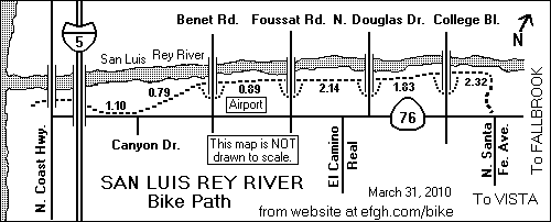
This is a fairly long, level path with no traffic lights or street crossings. Currently, part of the path runs along two residential streets for about 0.2 miles. A separate path in this area is planned but awaits approval of environmental authorities.
The path begins at the west end of Neptune Way, just a short distance west of Cleveland Street (Thomas 1085 J7). A sidewalk on Neptune Way might be considered an extension of this path to Cleveland Street.
It runs north along the east side of the railroad tracks. A paved 419-foot side path leads under the railroad tracks just south of the San Luis Rey River and up to Pacific Street.
The main path turns eastward and runs along the south bank of the San Luis Rey River, passing under the Coast Highway (formerly Hill Street), Interstate Highway 5, Benet Road, Foussat Road, Douglas Drive, and College Blvd., in that order.
There is no good access to the Coast Highway and no access to Interstate Highway 5, but there are access ramps to both sides of Benet Road, Foussat Road, Douglas Drive, and College Blvd. There is a new city park on the west side of College Blvd. right next to the path.
The path emerges on the north side of Andrew Jackson Street almost opposite Polk Street (Thomas 1067 B6).
The bike route runs roughly west on Andrew Jackson Street, which turns south and becomes Tyler Street.
A second part of the path, which opened on March 31, 2010, begins on the southeast side of Tyler Street near Harding Street and comes to an end at the northern corner of Via Manos and N. Santa Fe Ave., very near California State Highway 76 (Thomas 1067 C7).
There are plans to fill in the missing part of the path between the river and Andrew Jackson and Tyler Streets, and to extend the path through Guajome County Park (Thomas 1067 D7), and perhaps on to Melrose Dr.
There is informal access to the neighborhoods and areas to the south of the path in many places between Foussat Rd. and College Blvd. These areas are also honeycombed with single-track trails used by mountain bikers, hikers and dog-walkers. However, there is no access to Frazee Road, which is separated from the path by a large drainage ditch and a chain-link fence.
A bridge over a drainage ditch connects the path to Cypress Rd. (Thomas 1086 F1). See photograph.
Two short, steep, and well-trodden informal paths connect the bike path to the north side of California State Highway 76 at Canyon Dr. and Loretta St. There is a pedestrian signal that bicyclists can use at Canyon Dr., but not at Loretta St. Although a three-foot-high barrier lines the north side of Highway 76, there are gaps in the barrier at these two intersections.
The path formerly ended on the north side of Highway 76 just east of the interchange with Interstate 5, right next to an unused offramp from Interstate 5, and quite close to Call Box 76-01 (Thomas 1086 A6). An unpaved but flat path still connects the bike path to the north side of Highway 76. However, crossing to or from the south side is difficult because the traffic light has no pedestrian crossing phase.
There is no direct access to N. Coast Highway from the path, and there probably never will be. The bridge is quite high and the access paths would have to be unreasonably steep. Indirect access is available through a housing development called Seacliff.
The path is signed as the "San Luis Rey River Trail" in several places.
Pavement markings on the path in many places show the distance in miles from the west end.
Last explored: 3-31-2010
This path begins on the west side of the S. Coast Highway (formerly Hill St.) just south of Loma Alta Creek (Thomas 1106 C3, N 33 10.802 W 117 21.984). It runs southwest next to the creek, passes under the railroad tracks, and ends at the northeast corner of the parking lot in Buccaneer Beach Park (Thomas 1106 B3, N 33 10.635 W 117 22.104).
The official name of this path, as it appears on a sign at the path entrance on S. Coast Highway, is Loma Alta Creek Nature Trail.
Last explored: 06-12-2015
This path, which is part of the Coastal Rail Trail, begins on the northeast side of Myers Street near Morse Street (Thomas 1106 B3, N 33 10.592 W 117 22.018). It runs southeast along the northeast side of Myers Street to Cassidy Street (Thomas 1106 C3, N 33 10.434 W 117 21.883).
Southbound bicyclists following the Coastal Rail Trail cross the railroad on Cassidy Street and enter the Broadway Street Bike path on the other side of the railroad crossing.
Although it is signed as a bike path, most bicyclists prefer to ride in the street.
This path, and the Broadway Street Bike Path, are shown as a single path on the Oceanside map.
Last explored: 7-11-2014
This path, which is part of the Coastal Rail Trail, runs along the southwest side of Broadway Street from Cassidy Street (Thomas 1106 C3, N 33 10.446 W 117 21.838) to Vista Way (Thomas 1106 C4, N 33 10.263 W 117 21.666).
Although it is signed as a bike path, most bicyclists prefer to ride in the street.
This path, and the Myers Street Bike Path, are shown as a single path on the Oceanside map.
Last explored: 7-11-2014
This path runs along the west side of Coast Highway (formerly Hill Street) and Carlsbad Blvd. (Thomas 1106 D4) from Eaton Street in Oceanside (N 33 10.230 W 117 21.502) to State Street in Carlsbad (N 33 9.963 W 117 21.281), crossing Buena Vista Lagoon.
The path is part of the Coastal Rail Trail, and it may be extended farther, especially at the south end. The adjacent street retains its bike lanes, which will probably be preferred by most bicyclists.
Last explored: 7-11-2014
Pier View Way in Oceanside doesn't cross the railroad tracks. The two parts of this street are connected by two paths -- one for pedestrians and one for bicyclists -- that pass under the tracks between Myers Street and Cleveland Street (Thomas 1086 A7).
A new sign, warning bicyclists of a possible tsunami hazard, has been posted on the east end.
Last explored: 4-14-2009
This bike path, which is part of the Coastal Rail Trail, runs along the west side of the Amtrak and Coaster railroad tracks in Oceanside from Oceanside Blvd. (N 33 10.936 W 117 22.283) to the Oceanside Transit Center at the end of Tyson St. (N 33 11.498 W 117 22.765).
Most of the Transit Center is east of the tracks, but there is a pedestrian undercrossing with wheelchair ramps that bicyclists can use to walk bikes to the other side.
Near the north end of the path is a "Bikestation", a small indoor bicycle parking area. (See picture).
North of Wisconsin St. the path runs through a narrow parking lot. However, it has its own dedicated space, crossing from one side to the other near a fee payment station. (See picture).
Last explored: 2-19-2016
This asphalt path runs along the northwest side of Mesa Drive from N. Santa Fe Ave. (Thomas 1087 D1) to Sagewood Dr. (Thomas 1087 C2).
It's obviously not a sidewalk, because there is a concrete sidewalk between it and Mesa Drive.
There is a short (260 feet) side path through Alamosa Park to the corner of Rio Plata Dr. and Alamosa Park Dr.
This path is shown on the Oceanside map, but only as a Class II route (bike lanes in street).
Last explored: 10-7-1998
Along the south side of N. River Road near the North River Road Park Activity Center (Thomas 1067 H6), there is a paved path on top of the levee between the road and the San Luis Rey River.
The purpose of this path is something of a mystery. It does not appear to be connected to other paths. Perhaps it will some day be part of a longer path along this bank of the river.
This path is not shown on the Oceanside map.
Last explored: 5-30-1999
When a new bridge was built to carry Highway 76 over the San Luis Rey River just south of Bonsall (Thomas 1067 H5), the old 1925 bridge, and the road leading to it, were closed to motor vehicles, but left open for pedestrian, bicycle and equestrian use. See photograph.
The closed portion begins near the north end of the new bridge at the southwest corner of the intersection of Highway 76 and Holly Lane. It ends at the south end of the old bridge, on the northwest side of Old River Road, 0.12 miles north of the intersection with Highway 76.
The new bridge has ample shoulder space for bicyclists, but bicyclists traveling on Highway 76, especially westbound bicyclists, may find the old bridge a pleasant relief from the pounding traffic on Highway 76.
The RideLink map shows this as a red route.
This path is not shown on the Oceanside map, because it lies outside the city limits.
Last explored: 3-13-2008
This little path starts on the west side of Old Highway 395, runs along the north bank of Rainbow Creek under Interstate 15 and emerges on Oak Crest Road, which is a private road serving Oak Crest Estates (Thomas 998 G5). It offers residents of Oak Crest Estates more direct access to the little business district at the corner of Old Highway 395 and Fifth Street than the Rainbow Glen Road undercrossing.
Last explored: 12-23-1998
The Border Patrol tries to keep an eye on this bike path, because it bypasses the San Onofre Inspection Station on Interstate 5. It is entirely within San Diego County but outside the area covered by the RideLink map.
The path begins on the north side of Las Pulgas Road, just a short distance east of the Las Pulgas Road interchange on Interstate 5 (Thomas 408 K7, N 33 18.032 W 117 27.826). At the beginning of the path is a small parking area which recreational cyclists often use. The path runs north on a section of Old Highway 101 which is no longer open to automobiles.
A half-mile stretch of Old Highway 101 has been repaved for use as a military landing strip. When the landing strip is in use, the bike path is closed, often with little or no prior notice. Bicyclists are forced to detour onto the shoulders of Interstate 5, which is opened to them when the bike path is closed.
The path turns west and passes under Interstate 5 through a narrow (one-lane) tunnel called the Don Undercrossing. On the other side of Interstate 5, it turns north and joins another section of old Highway 101.
The separated path ends at a barrier marking the southern end of San Onofre State Beach Campground (Thomas 408 K7, N 33 20.058 W 117 30.072).
Bicyclists traveling north on this path to San Clemente should continue through the campground and then up Old Highway 101 to enter the Trestles Bike Path.
Bicyclists with proper identification traveling south on this path to Oceanside should turn east on Las Pulgas Road and then follow the bike route signs through Camp Pendleton. Although Interstate 5 is open to bicycle traffic from Las Pulgas Road south to the Oceanside Harbor Drive interchange, few bicyclists are willing to ride on Interstate 5 as long as the alternative route through Camp Pendleton is open.
You must wear a helmet when riding through Camp Pendleton. The guards won't let you in without one.
The bike route through Camp Pendleton was closed to civilians from September 11, 2001 to February 3, 2005. After January 31, 2016 it will be closed to most civilians. Now it is open during the daytime. When the base is closed, and after January 31, 2016, civilian bicyclists must ride on Interstate 5 unless escorted through Camp Pendleton by a person with proper military identification. You may also be able to use some kinds of civilian identification, but only if you register in advance.
Last explored: 4-19-2013
This path completes the bike route along the Interstate 5 corridor in San Diego County. It is entirely within San Diego County, but it is outside the area covered by the RideLink map.
The path begins on the west side of Old Highway 101, just a short distance south of the Basilone Rd. and San Onofre interchange on Interstate 5 (Thomas 1023 D3, N 33 23.013 W 117 34.920). There is a marked crosswalk for the use of northbound bicyclists.
The path runs north along the west side of Old Highway 101, separated from the highway by a fence. A gap in the fence at the south end of the path provides access to the highway.
At the interchange, the highway turns east, but the bike path continues north on a section of Old Highway 101 that is no longer open to automobiles.
Just north of the bridge over San Mateo Creek, a side path runs 0.4 mile west to Trestles Beach.
The path emerges on the south side of Cristianitos Road just west of the Cristianitos Rd. interchange on Interstate 5 (Thomas 1023 B2, N 33 23.694 W 117 35.624), and very close to the Orange County Line.
Last explored: 4-19-2013
This path begins on the north side of Aten Road, 0.12 miles west of the main entrance to Imperial Valley College, for which the path is named (Thomas 6500 E1, N 32 49.544 W 115 30.410).
It runs west along the north side of Aten Road and within a few feet of it as far as the intersection with Clark Road (Thomas 6499 G2, N 32 49.534 W 115 33.680). The signs on the path describe it as a "bike lane".
At and near the intersection of Aten Road and Clark Road, the two streets are signed as "Aten Blvd", and "Clark Ave", respectively. North of the intersection, Clark Ave is signed as "P St".
At the west end, an extension runs north about 0.5 miles along the east side of Clark Road to Rosarito Drive (Thomas 6499 G1, N 32 49.947 W 115 33.680).
The path is paved with asphalt, and is of acceptable quality for road biking. The part of the path east of Dogwood Road is somewhat higher and smoother; it appears to have been repaved not too long ago. The path may be covered with small rocks and dirt in some places, mostly from agricultural operations next to the path.
The name "Imperial Valley College Bike Path" has some official status; it is used in the Imperial County Bicycle Master Plan. It is also used by Google Maps.
There were plans to improve this path and perhaps extend it westward an additional 0.49 miles to Imperial Avenue. However, this was not done at the time of my first survey on 4-2-2000, and had still not been done at the time my most recent survey on 2-12-2012.
Believe it or not, this is the only separated bike path in Imperial County. At an elevation of -60 feet, it is probably also the lowest bike path in North America.
Last explored: 2-12-2012 (some updates in November 2007 from Noel Keller)
The Colorado River near downtown Yuma, Arizona runs approximately east to west.
This path begins in Gateway Park, approximately under the bridges carrying Old Highway 80 and a railroad track over the Colorado River.
It runs west (downstream) along the south side of the Colorado River, passing to the north of the Yuma Quartermaster Depot State Historic Park, which was formerly called the Yuma Crossing State Historic Park.
The path passes under the Fourth Avenue Bridge (see photograph), and continues west, parallel to the Yuma Valley Railroad and very close to it, crossing it three times at grade level.
The path ends at the northeast corner of the Joe Henry Athletic Fields, whose main entrance is at the corner of 23rd Ave. and Colorado Street.
Signs on the path state: "This path was financed in part with a grant from the Arizona Heritage Trails Fund administered by the Arizona State Parks Board."
The name "Yuma Crossing Bike Path" apparently has some official status, having appeared in the agenda for a Yuma City Council meeting on January 17, 2001. Another name is "Colorado River Levee Multi-Use Path", which appears in the City of Yuma 2002 General Plan. A third name is the "Colorado River Path", which appears on signs at both ends.
Just north of the path at 12th Ave. is the West Wetlands Park, which features a boat launch ramp and a rather elaborate playground.
Last explored: 11-5-2009
This path begins on the Yuma Crossing Bike Path just east of 4th Avenue. It runs south next to 4th Avenue, crossing the entrance to the Yuma Quartermaster Depot State Historic Park. It then turns east and runs along a small canal. It crosses the canal and continues east to the parking lot for the Pivot Point Conference Center at the north end of Madison Ave.
This little path apparently has no official name, but a tiny sign on the Yuma Crossing path says that it goes to N. Madison Ave.
Last explored: 11-5-2009
This path begins on the Yuma Crossing Path about 0.48 miles west of Fourth Ave. It runs south and soon approaches the East Main Canal.
About 0.20 miles south of Yuma Crossing Path, this path crosses 1st Street and also switches from the west to the east side of the canal. There is a marked crosswalk on the east side, but no traffic light.
The path then follows the east bank of the canal south as far as 24th Street. Here it turns east and emerges on the northwest corner of Ridgeview Dr. and 24th Street.
The path does not end there. A second part of the path begins on the south side of 24th Street, just east of the canal. It resembles a paved driveway and is unsigned. About 0.15 miles farther south, the path veers off the driveway and once again looks like a bike path.
The path continues south along the east side of the canal to a point just 0.11 miles north of 32nd Street. Here automotive access to the path is blocked by bollards, and there is a small sign.
An unpaved path, mostly hard-packed but with some soft spots, continues south to the north side of 32nd Street. There is a continuation path on the south side of 32nd Street, but it is unpaved. I have been told it goes as far south as 40th Street, but I haven't explored that area.
It appears that there are plans to widen 32nd Street. There is an unused second bridge over the canal just north of the existing street. This could be the reason why the path wasn't paved all the way to 32nd Street.
There are stop signs at 1st Street, traffic lights at 3rd Street, 5th Street and 24th Street, and a tunnel under 16th Street (Highway 95), which makes it fairly easy to cross those streets. However, it is very difficult to cross 8th Street and 32nd Street because traffic is heavy and there are no traffic lights or other control devices.
The name "East Main Canal Bike Path", which appears in the City of Yuma 2002 General Plan, has some official status. Another name is "East Main Canal Multi-use Pathway", which appeared in a list of projects financed by TEA-21 funds.
Last explored: 11-5-2009 (updates as of 11-28-2007 from Noel Keller)
This path begins on the south side of 20th Street opposite 23rd Drive, which is just one block east of Avenue B (US Highway 95).
It runs east along the south side of 20th Street. The street ends just short of the East Main Canal. The path continues south along the west side of the canal and emerges on Camino Tierra at the corner near the north end of the street.
A small bridge over the canal connects this path to the East Main Canal Bike path.
Last explored: 11-5-2009
This path begins on the southeast corner of 32nd St. and Pacific Ave., right next to the entrance to Yuma International Airport. It runs east along the north side of 23nd St. as far as the intersection with Avenue 3E. There it turns south and runs along the west side of Avenue 3E as far as the Main Gate of the Marine Corps Air Station.
Last explored: 11-5-2009
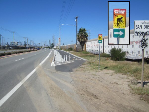