
|
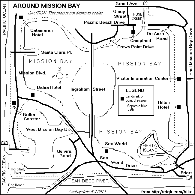
Around Mission BaySan Diego, California |
Please e-mail comments, corrections and additions to the webmaster at pje@efgh.com.
|
|
Around Mission BaySan Diego, California |
Please e-mail comments, corrections and additions to the webmaster at pje@efgh.com.
An easy 14-mile ride around scenic Mission Bay, mostly on separated bike paths. Good views of the ocean and the bay. Several optional side trips. The recently completed bike path and bridge over the mouth of Rose Creek makes this ride better than ever.
Approximate distances from the starting point are given in miles.
The first 1.55 miles and the last 1.00 miles can be covered on a separated bike path, instead of East Mission Bay Drive. However, most bicyclists prefer to ride on East Mission Bay Drive, which is an official Class III bike route.
Near the midpoint of the ride is Hamel's bike rental. If you need to rent a bicycle for this ride, you might start and end your ride there. However, this is near a very popular beach; parking is usually tight on weekends and holidays.
Start at the Mission Bay Visitor Information Center on East Mission Bay Drive at the foot of Clairemont Drive, near the Clairemont Drive exit from Interstate 5. Parking next to the Center is limited to one hour, and this ride will almost certainly take longer than that. Park in one of the nearby parking lots to the north or the south of the Center.
00.00 RIGHT onto East Mission Bay Dr. when leaving the Visitor Information Center.
01.55 RIGHT onto the sidewalk/path just after crossing Fiesta Island Rd.
SIDE TRIP: A ride around Fiesta Island will add about five miles to the total distance.
01.64 RIGHT onto an asphalt bike path.
02.04 LEFT onto a concrete path.
02.18 LEFT onto an asphalt path.
02.30 Cross the road and turn LEFT onto a path on other side.
02.50 Cross Sea World Drive, using the pedestrian signal.
02.53 RIGHT onto a road next to river. Follow this road west, passing under two bridges. Automobiles are permitted along part of this path, which used to carry through traffic before Sea World Drive was built.
03.75 RIGHT onto Quivira Rd.
SIDE TRIP: Keep going west to Hospitality Point and the jetty between Mission Bay Channel and the San Diego River. Return by the same route.SIDE TRIP: After going a short distance down Quivira Road, turn right into another bike path and follow it across the San Diego River on the Sunset Cliffs Bridge, which has separate lanes for automobiles, bicycles and pedestrians. On the other side of the river, turn right and ride west along the south bank of the San Diego River to Dog Beach. Return by the same route.
04.41 RIGHT onto an unmarked street.
04.44 LEFT onto W. Mission Bay Drive at a traffic light.
05.09 LEFT onto Mariners Way at a traffic light. To the right is the Bahia Hotel.
Veer right and then left and ride on a path parallel to the bayshore.
06.04 LEFT onto a path around Mission Point.
06.50 LEFT onto a road.
CROSS the south end of Mission Blvd. and continue into a parking lot.
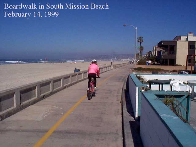
06.71 RIGHT into the Boardwalk (Ocean Front Walk, actually paved with concrete). Click here for a picture of the Boardwalk.
07.59 PASS Ventura Place, near the roller coaster and Hamel's bike rental.
08.31 RIGHT onto Santa Clara Place. It's just after Ostend.
SIDE TRIP: Ocean Front Walk and other bike paths continue along the shore as far north as far as Crystal Drive in Pacific Beach.
Cross Mission Blvd. and continue. Do NOT turn left into the alley marked Bayside Lane.
08.44 LEFT into a path (Bayside Walk).
11.22 Enter a parking lot at the end of the path.
11.28 RIGHT when leaving the parking lot.
11.43 RIGHT onto Crown Point Dr.
11.80 RIGHT onto Pacific Beach Dr.
11.96 STRAIGHT AHEAD at Olney St.
12.11 Enter bike path near entrance to Campland.
12.46 Leave bike path and continue on N. Mission Bay Dr., which becomes E. Mission Bay Dr.
13.57 RIGHT into the Visitor Information Center.
Last revised May 9, 2012.