|
|
County Highway S6January 9, 2003 - Philip J. Erdelsky, pje@efgh.com |
County Highway S6 begins at the intersection of Via De La Valle and Highway 101 in Solana Beach, just northwest of the Del Mar Racetrack. It runs east and north for over fifty miles, passing through Escondido and Valley Center. It then climbs the south side of Mount Palomar and turns west near the summit, coming to an end at the visitors' parking lot for Palomar Observatory. It gains almost exactly one mile in altitude and passes through some of the most scenic parts of San Diego County.
County Highway S6 has mile markers every mile, or in some cases every half-mile, in rural areas. The markers show mileages quite close to those in the table below.
The following table lists the major intersections and landmarks on County Highway S6:
| miles from west end | left (for eastbound traveler) | control | right (for eastbound traveler) | remarks |
|---|---|---|---|---|
| 0.0 | Highway 101 | traffic light | Highway 101 | County Highway S6 begins |
| 0.7 | Valley Ave | traffic light | Jimmy Durante Blvd | |
| 0.9 | Interstate 5 NORTH | interchange, traffic lights | Interstate 5 SOUTH | |
| 1.2 | San Andres Dr | traffic light | San Andres Dr | |
| 2.3 | traffic light | El Camino Real | ||
| 2.5 | El Camino Real | traffic light | ||
| 3.7 | Cancha De Golf | |||
| 4.8 | Calzada Del Bosque | traffic light | Calzada Del Bosque | |
| 5.6 | Via De Santa Fe | |||
| 5.7 | Via De Santa Fe | |||
| 6.2 | County Highway S8 WEST, Paseo Delicias | 4-way stop | County Highway S6 EAST, Paseo Delicias | |
| 6.9 | El Montevideo | 4-way stop | La Valle Plateada | |
| 7.5 | El Camino Del Norte | |||
| 8.8 | traffic light | Bing Crosby Blvd | ||
| 9.1 | Calle Ambiente | traffic light | ||
| 11.0 | Lake Hodges Dam (see photograph) | |||
| 12.4 | Rancho Drive | |||
| 12.5 | Mount Israel Rd | |||
| 14.0 | Date Lane | |||
| 14.5 | traffic light | Via Rancho Pkwy | ||
| 15.1 | Citracado Pkwy | traffic light | Citracado Pkwy | |
| 15.9 | Eleventh Ave | traffic light | Eleventh Ave | |
| 16.1 | Ninth Ave | traffic light | Ninth Ave | |
| 16.3 | Auto Park Way | traffic light | Auto Park Way | |
| 16.6 | Interstate 15 NORTH | interchange, traffic lights | Interstate 15 SOUTH | |
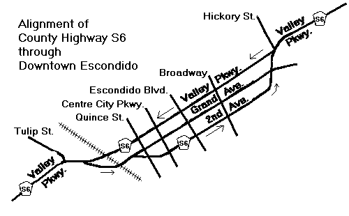
| 16.8 | Tulip St | traffic light | separate from westbound County Highway S6 | |
| 17.1 | railroad grade crossing | |||
| 17.2 | Quince St | traffic light | Quince St | |
| 17.4 | Centre City Pkwy | traffic light | Centre City Pkwy | |
| 17.5 | Escondido Blvd | traffic light | Escondido Blvd | |
| 17.7 | Broadway | traffic light | Broadway | |
| 18.1 | Grand Ave | traffic light | Grand Ave | |
| 18.2 | Hickory St | traffic light | ||
| 18.4 | Fig St | traffic light | Fig St | |
| 18.8 | California Highway 78 WEST, Ash St | traffic light | California Highway 78 EAST, Ash St | |
| 19.0 | Harding St | traffic light | Harding St | |
| 19.3 | Rose St | traffic light | Rose St | |
| 19.8 | Midway Dr | traffic light | Midway Dr | |
| 20.3 | Citrus Ave | traffic light | Citrus Ave | |
| 20.8 | Bear Valley Pkwy | |||
| 21.2 | Washington Ave | traffic light | Hidden Trails Rd | |
| 22.0 | traffic light | Lake Wohlford Rd | ||
| 25.5 | Woods Valley Rd | |||
| 26.7 | Lilac Rd | traffic light | ||
| 27.5 | Miller Rd | |||
| 28.0 | Cole Grade Rd | traffic light | ||
| 31.0 | Thundernut Lane | N Lake Wohlford Rd | ||
| 32.5 | cattle guard | |||
| 34.1 | San Luis Rey River | |||
| 34.3 | Harrah's Casino and Resort | traffic light | ||
| 35.6 | cattle guard | |||
| 35.9 | California Highway 76 WEST | stop (eastbound only) | County Highway S6 EAST, California Highway 76 EAST | |
| 40.9 | County Highway S6 EAST, South Grade Road | yield (westbound only) | Calle El Potrero | |
| 41.3 | cattle guard | |||
| 41.7 | cattle guard | |||
| 42.9 | cattle guard | |||
| 47.8 | County Highway S6 EAST, County Highway S7 WEST, Canfield Rd | yield (eastbound only) | County Highway S7 WEST, East Grade Rd | |
| 47.9 | County Highway S7, State Park Rd | |||
| 49.3 | cattle guard | |||
| 50.2 | Observatory Campground | |||
| 50.4 | Fry Creek Campground | |||
| 51.4 | cattle guard | |||
| 52.3 | County Highway S6 ends (see photograph) |
NOTE: Between Tulip St. and Hickory St. in Escondido, County Highway S6 splits into two parts. Eastbound County Highway S6 runs along Grand Ave., 2nd Ave. and S. Valley Blvd., while westbound County Highway S6 stays on Valley Pkwy.