|
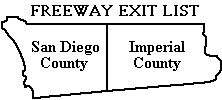
A list of freeway exits in San Diego and Imperial Counties and some
parts of Orange and Riverside Counties.
August 17, 2007 - Philip J. Erdelsky,
pje@efgh.com
|
- Introduction
- Interstate Highway 5 (San Diego Freeway)
- Interstate Highway 8 (Ocean Beach, Alvarado and Kumeyaay Freeways)
- California Highway 15 and Interstate Highway 15 (Escondido Freeway)
- Interstate Highway 805 (Jacob Dekema Freeway)
- California Highway 163 (Cabrillo Freeway)
- California Highway 94 (Martin Luther King Jr. Freeway)
- California Highway 125 (Helix Freeway, South Bay Expressway)
- California Highway 78
- California Highway 52 (San Clemente Canyon Freeway)
- California Highway 54 (South Bay Freeway)
- California Highway 56 (Ted Williams Parkway)
- California Highway 67 (San Vicente Freeway)
- California Highway 905
- Kearny Villa Road
- Interstate Highway 215 (Escondido Freeway)
- California Highway 73 (San Joaquin Hills Tollroad)
- California Highway 1 (Pacific Coast Highway)
- Interstate Highway 405 (San Diego Freeway)
- California Highway 241 (Foothill/Eastern Tollroad)
- Epilogue
Return to home page.
EXIT SIGNS
Nearly every freeway exit in Southern California and Arizona is
marked by a sign with white lettering on a green background. Each entry
in this document shows, as nearly as possible, the wording on the exit
sign, and the approximate distance in miles from the beginning of the
listed part of the freeway to the exit. This information should be
useful in estimating travel distances and giving precise directions,
since some freeway exits in Southern California are not yet numbered.
Most freeway exits in Arizona are numbered. The exit
number is the approximate number of miles from the south or west end of
the freeway, or the place where it enters Arizona from the south or
west. Exits less than one mile apart are distinguished by letters
after the exit numbers.
Freeway exit numbers may not be precisely consistent with the
mileages given in this list because eastbound and westbound exits to
the same highway are given the same number, even though they may be
more than a mile apart.
Freeway exits in California are being numbered during the three-year
period from 2002 to 2004, following generally the same pattern as Arizona
exit numbers.
Numbers have already been assigned or proposed for
all exits, and are shown on this list as comments.
Some numbers
have already been posted, but they are not necessarily on the exit
signs. They may be on other signs near the exits. In many cases, a sign
that formerly said merely "EXIT" or "RAMP" has been replaced by one that
contains the word "EXIT", the exit number and an arrow. Also, the
exit number usually appears on a secondary sign some distance before the exit
itself.


When an exit number is added to an exit sign, the wording of the
sign is sometimes changed slightly. Such changes will be reflected
in this list as soon as possible.
For the latest
information on California freeway exit numbers, check the Caltrans
Web page at
www.dot.ca.gov/hq/traffops/signtech/calnexus/index.htm. These
pages are updated occasionally to show which exit numbers have been posted.
The 2003 and later Thomas Guides show freeway exit numbers on the detail maps.
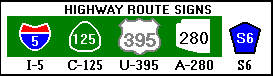
SYMBOLS USED ON EXIT SIGNS
A few symbols are used on exit signs. Since this document consists
almost entirely of text, abbreviations are used to represent some of
these symbols:
-
A California state highway is represented by enclosing the route
number in a triangle with rounded sides. In this document, the
prefix "C-" is used for this purpose. Hence C-125 represents the
number 125 enclosed in such a triangle.
-
An interstate highway is represented by enclosing the route number
in a shield with a blue background. At the top of the shield is the
word "INTERSTATE" in white letters on a red background. In this
document, the prefix "I-" is used for this purpose. Hence I-5
represents the number 5 enclosed in such a shield.
-
A federal highway is represented by enclosing the route number
in a black-and-white shield of a different shape. In this
document, the prefix "U-" is used for this purpose. Hence U-395
represents the number 395 enclosed in such a shield.
-
An Arizona state highway is represented by enclosing the route
number in an outline of Arizona. In this document, the prefix
"A-" is used for this purpose. Hence A-280 represents the number
280 enclosed in such an outline.
Commas are used in this document to divide exit sign text into logical
groups. The commas themselves do not appear on exit signs.
In fact, exit signs usually do not contain punctuation of any kind.
Here are pictures of some typical route markers:
A few route markers in Arizona listed as "Business I-8" are actually
modified
interstate highway shields with the word "Business" above the route
number.
OTHER MATERIAL ASSOCIATED WITH EXITS
Explanatory material that does not appear on exit signs is enclosed in
parentheses. For example, in the few cases where an exit is on the left
side, that fact is noted. Freeway exit numbers, where
available, are enclosed in parentheses.
San Diego, Imperial and Orange County route numbers,
consisting of the letter "S" and a number, do not appear on exit
signs. However, interchanges with county highways are often marked by
auxiliary signs some distance ahead of the exits themselves. In this
list, such interchanges are noted in explanatory material.
Riverside County route numbers consist of the letter "R" and a number.
Some extraneous words that do appear on exit signs, such as
"Exit Only", have been omitted from this list.
Bicycles are permitted on the shoulder of the freeway in California
wherever the following symbol appears:

Bicycles are permitted on the shoulders of I-8 in Arizona, except
possibly in some parts of Yuma and Casa Grande. Bicycles are definitely
not permitted on I-10 near Casa Grande or on the bridge carrying I-8
over the Colorado River into California.
FREEWAY NAMES
Most freeways in Southern California are now identified by number, not
by name. However, freeway names have been noted in the section headings.
In recent years, small signs have been posted on some freeways marking
them as memorials to individuals. Where available, these names are mentioned in the
introductory text for each freeway.
CALL BOXES
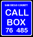 |
There are now emergency call boxes on freeways in San Diego, Imperial,
Orange, and Riverside Counties, but not in Arizona. Each one is marked
by a rectangular sign with the words "Call Box" in white lettering on a
blue background. At the bottom of the sign are two numbers. The first is
the highway number, and the second is the approximate distance, in
tenths of a mile, from the southern or western end of the highway (or
the place where it enters the county) to the call box. In the case of
highways under construction, the distance is apparently measured from what
will be the end of the highway when it is finished.
|
In San Diego County, call boxes on the south and east sides of
freeways bear even numbers and call boxes on the north and west sides bear
odd numbers. (This convention is the opposite of that used for building
numbers in much of the San Diego area.) The convention in other counties
may be different.
There are also call boxes on state highways that are not freeways,
on a few roads that are not state highways or freeways,
and in a few other places. Call boxes were
put on I-8 in Imperial County in early 2000; before that time there were no
call boxes in Imperial County.
Many call boxes have keyboards for use by motorists with
speech and/or hearing impairments.
There are carpool lanes on I-5 in Orange County north of the C-1 exit.
In some places, there are exits from the carpool lanes that are not
accessible from the regular lanes. This list contains only exits accessible
from the regular lanes.
The part of I-5 south of Downtown San Diego is sometimes called the
Montgomery Freeway.
The part of I-5 north of the junction with I-405 is called the
Santa Ana Freeway. The name "San Diego Freeway" is applied to I-405.
I-5 runs parallel to old US Highway 101 and has entirely replaced it
within San Diego County.
Carlsbad Village Dr. was formerly called Elm Ave. The old name is still
used by some Carlsbad residents and appears on exit signs in tiny letters.
Coast Hwy. in Oceanside was formerly called Hill Street. The old
name still appears on some exit signs in tiny letters.
The part of I-5 running through Camp Pendleton is signed as the
"Gunnery Sergeant John Basilone Freeway".
I-5 has been widened and improved between the junction with I-805
and the Del Mar Heights Road interchange. The work, which was
completed in April 2007, includes local bypass lanes and
a new interchange with Carmel Mountain Road, which is accessible
only from the local bypass lanes.
This list now includes all exits from I-5 in Orange County and a few exits
in Los Angeles County.
I-5 Northbound
- 000.0 - (freeway begins at US-Mexico border)
- 000.3 - (exit 1A) NORTH I-805 (also San Ysidro Blvd)
- 000.8 - (exit 1B) Via de San Ysidro
- 002.0 - (exit 2) Dairy Mart Road
- 002.6 - (exit 3) C-905 EAST, Tocayo Ave
- 003.7 - (exit 4) Coronado Ave
- 004.4 - (exit 5A) Palm Avenue, C-75
- 005.3 - (exit 5B) Main Street
- 005.8 - (exit 6) Palomar St
- 006.5 - (exit 7A) L Street
- 007.1 - (exit 7B) J Street, Marina Pkwy
- 007.7 - (exit 8A) H Street
- 008.5 - (exit 8B) E Street
- 009.0 - (exit 9) C-54 EAST
- 010.1 - (exit 10) Mile of Cars Way, Bay Marina Dr (formerly 24th Street)
- 010.6 - (exit 11A) Harbor Dr, Civic Center Dr
- 010.9 - (exit 11B) Plaza Blvd, Downtown (Downtown National City)
- 011.9 - (exit 12) Main St, Division St
- 012.5 - (exit 13A) NORTH C-15, Riverside
- 013.4 - (exit 13B) 28th Street, National Ave
- 014.1 - (exit 14A) Coronado, C-75 TOLL CROSSING
- 014.3 - (exit 14B) Cesar E Chavez Parkway (formerly Crosby Street)
- 014.9 - (exit 15A) C-94 EAST, J Street, M L King Jr Fwy
- 015.2 - (exit 15B) Pershing Dr, Civic Center (also B Street)
- 016.2 - (exit 16A) NORTH C-163, Escondido
- 016.5 - (exit 16B) 6th Avenue, Downtown (Downtown San Diego)
- 017.0 - (exit 17A) Hawthorn Street, San Diego Airport
- 017.7 - (exit 17B) Sassafras St (also India Street)
- 017.9 - (exit 18A) Pacific Highway
- 018.3 - (exit 18B) Washington Street
- 019.3 - (exit 19) Old Town Avenue
- 020.2 - (exit 20) I-8 WEST Beaches, I-8 EAST El Centro
- 021.2 - (exit 21) Sea World Drive, Tecolote Road
- 022.6 - (exit 22) Clairemont Drive, Mission Bay Drive
- 023.3 - (exit 23A) Grand Avenue, Garnet Avenue
- 023.9 - (exit 23B) EAST Balboa Avenue (Balboa Ave formerly also C-274)
- 026.3 - (exit 26A) WEST La Jolla Pkwy (formerly Ardath Rd)
- 026.4 - (exit 26B) C-52 EAST
- 027.3 - (exit 29) Gilman Drive, La Jolla Colony Dr (also UCSD)
- 028.7 - (exit 28A) Nobel Dr
- 029.0 - (exit 28B) La Jolla Village Dr
- 030.1 - (exit 29) Genesee Ave
- 030.9 - (exit 30) Sorrento Valley Rd
- 031.3 - LOCAL BYPASS, Jct C-56 EAST (also Carmel Mountain Rd)
- 032.7 - (exit 32) Carmel Mountain Rd (accessible only from LOCAL BYPASS)
- 033.6 - (exit 33A) C-56 EAST (accessible only from LOCAL BYPASS)
- 033.7 - (exit 33B) Carmel Valley Road
- 034.9 - (exit 34) Del Mar Heights Road
- 037.1 - (exit 36) Via De La Valle (also S6)
- 038.3 - (exit 37) Lomas Santa Fe Dr, Solana Beach (also S8)
- 039.7 - (exit 39) Manchester Ave
- 040.8 - (exit 40) Birmingham Dr
- 041.6 - (exit 41A) Santa Fe Dr, Encinitas
- 042.6 - (exit 41B) Encinitas Blvd (also S9)
- 043.8 - (exit 43) Leucadia Blvd
- 045.3 - (exit 44) La Costa Ave
- 046.8 - (exit 45) Poinsettia Lane, Aviara Pkwy
- 048.3 - (exit 47) Palomar Airport Road (also Carlsbad Blvd, S12)
- 049.3 - (exit 48) Cannon Rd (also Legoland)
- 050.6 - (exit 49) Tamarack Avenue
- 051.5 - (exit 50) Carlsbad Village Dr (formerly Elm Ave)
- 052.1 - (exit 51A) Las Flores Dr
- 052.6 - (exit 51B) C-78 EAST, Escondido (also Vista)
- 052.9 - (exit 51C) Vista Way
- 054.0 - (exit 52) Oceanside Blvd
- 054.6 - (exit 53) Mission Ave, Downtown (Downtown Oceanside)
- 055.3 - (exit 54A) C-76 EAST, Coast Hwy (Coast Hwy formerly Hill St)
- 056.0 - (exit 54B) Camp Pendleton (also Capistrano Drive)
- 056.2 - (exit 54C) Oceanside Harbor Dr
- 061.1 - (exit 59) REST AREA (Aliso Creek)
- 064.0 - (exit 62) Las Pulgas Road
- 069.0 - (exit 67) WEIGH STATION
- 069.4 - (Border Patrol Checkpoint)
- 073.6 - (exit 71) Basilone Rd, San Onofre
- 074.5 - (exit 72) Cristianitos Road
- 075.9 - (exit 73) Ave Magdelena
- 076.3 - (exit 74) El Camino Real
- 077.0 - (exit 75) Ave Presidio, San Clemente
- 078.1 - (exit 76) Ave Pico
- 078.6 - (exit 77) Ave Vista Hermosa
- 080.6 - (exit 78) Camino de Estrella
- 081.3 - (exit 79) C-1, Beach Cities, Camino Las Ramblas
- 083.5 - (exit 81) Camino Capistrano (also San Juan Creek Rd, Valle Rd)
- 084.6 - (exit 82) Ortega Hwy, C-74, San Juan Capistrano
- 085.9 - (exit 83) Junipero Serra Rd
- 086.2 - (exit 85A) C-73 NORTH TOLL ROAD, Long Beach
- 088.1 - (exit 85B) Avery Parkway
- 088.8 - (exit 86) Crown Valley Pkwy
- 090.3 - (exit 87) Oso Pkwy
- 091.8 - (exit 89) La Paz Rd
- 092.7 - (exit 90) Alicia Pkwy
- 093.9 - (exit 91) El Toro Road (also S18, Laguna Hills, Lake Forest)
- 094.9 - (exit 92A) Lake Forest Dr
- 095.1 - (exit 92B) I-5 TRUCK BYPASS NORTH, Bake Pkwy
- 096.3 - (exit 94A) I-405 NORTH, Long Beach
- 097.4 - (exit 94B) Alton Pkwy
- 098.3 - (exit 95) C-133 NORTH TOLL, Riverside
- 099.3 - (exit 96) Sand Canyon Ave
- 100.1 - (exit 97) Jeffrey Rd (also Irvine Valley College)
- 101.7 - (exit 99) Culver Dr
- 102.7 - (exit 100) Jamboree Rd (also C-261 Toll Road)
- 103.5 - (exit 101A) Tustin Ranch Rd
- 104.3 - (exit 101B) Red Hill Ave, Tustin
- 105.5 - (exit 103A) C-55 NORTH Anaheim/Riverside
- 105.6 - (exit 103B) C-55 SOUTH
- 106.2 - (exit 103C) First St, Fourth St (also Santa Ana Zoo)
- 106.9 - (exit 104) Grand Ave, Santa Ana Blvd
- 107.6 - (exit 105A) 17th Street (also Santa Ana College)
- 108.2 - (exit 105B) Main St, Broadway
- 108.9 - (exit 106) C-22 WEST, Long Beach (also Bristol St and La Veta Ave.)
- 109.4 - (exit 107A) C-57 NORTH Pomona
- 110.1 - (exit 107B) Chapman Ave
- 110.3 - (exit 107C) State College Blvd, The City Dr
- 111.2 - (exit 109) Katella Ave, Disney Way (also Disneyland Resort)
- 112.5 - (exit 110) Harbor Blvd, Ball Rd
- 113.9 - (exit 111) Lincoln Ave
- 114.5 - (exit 112) Euclid St (some signs say Euclid Ave)
- 115.6 - (exit 113A) Brookhurst St, La Palma Ave
- 115.8 - (exit 113B) La Palma Ave East
- 116.9 - (exit 113C) C-91 WEST
- 117.0 - (exit 114) Magnolia Ave, C-91 EAST
- 118.1 - (exit 115) Auto Center Dr
- 118.7 - (exit 116) C-39, Beach Blvd
- 119.2 - (exit 117) Artesia Blvd
- 120.6 - (exit 118) Valley View Ave, La Mirada
- 122.0 - (exit 119) Carmenita Rd
- 122.8 - (exit 120A) Rosecrans Ave
- 123.1 - (exit 120B) C-42, Firestone Blvd (exit left)
- 123.8 - (exit 121) Norwalk Blvd, Norwalk
- 124.3 - (exit 122) Imperial Hwy, Pioneer Blvd
- 125.7 - (exit 123) Florence Ave
- 126.0 - (exit 124) I-605 Freeway SOUTH NORTH
- 127.7 - (exit 125) Lakewood Blvd, Rosemead Blvd, SOUTH C-19 NORTH
- 128.3 - (exit 126A) Paramount Blvd
- 129.2 - (exit 126B) Slauson Ave, Montebello
- 130.1 - (exit 128A) Garfield Ave
- 131.1 - (exit 128B) Washington Blvd, Commerce
- 132.1 - (exit 129) Atlantic Bl NORTH
- 132.4 - (exit 130A) I-710, Atlantic Blvd SOUTH, Long Beach Fwy SOUTH
- 133.0 - (exit 130B) Eastern Ave
- 133.2 - (exit 130C) I-710 NORTH, Long Beach Freeway, Pasadena (exit left)
I-5 Southbound
- 000.0 - (exit 130B) I-710 SOUTH, Long Beach
- 000.8 - (exit 130A) Triggs St
- 001.2 - (exit 129) Atlantic Blvd, Eastern Ave
- 002.1 - (exit 128B) Washington Blvd, Commerce
- 003.1 - (exit 128A) Garfield Ave, Bandini Blvd
- 003.9 - (exit 126B) Slauson Ave, Montebello
- 004.8 - (exit 126A) Paramount Blvd, Downey
- 005.4 - (exit 125) C-19, Lakewood Blvd, Rosemead Blvd
- 006.8 - (exit 124) I-605 Freeway NORTH SOUTH (also Florence Ave)
- 008.6 - (exit 122) Pioneer Blvd, Imperial Hwy
- 009.2 - (exit 121) San Antonio Dr, Norwalk Bl
- 010.5 - (exit 120) Rosecrans Ave, La Mirada (also Biola University)
- 011.5 - (exit 119) Carmenita Rd
- 012.7 - (exit 118) Valley View Ave (also La Mirada Theatre for the Performing Arts)
- 013.8 - (exit 117) Artesia Blvd, Knott Ave (also Knott's Berry Farm)
- 014.5 - (exit 116) Beach Blvd, C-39 (also Knott's Berry Farm)
- 015.4 - (exit 114B) C-91 EAST (also Riverside)
- 016.0 - (exit 114A) Magnolia Ave
- 017.2 - (exit 113) Brookhurst St, La Palma Ave
- 018.3 - (exit 112) Euclid St
- 018.7 - (exit 111) Lincoln Ave
- 019.8 - (exit 110B) Disneyland Dr, Ball Rd
- 020.6 - (exit 110A) Harbor Blvd (also Convention Center)
- 021.3 - (exit 109B) Disney Way, Anaheim Blvd (also Edison Field, Arrowhead Pond)
- 021.5 - (exit 109A) Katella Ave, Orangewood Ave
- 022.4 - (exit 107C) State College Blvd, The City Drive
- 023.5 - (exit 107B) C-22 WEST, Garden Grove
- 023.6 - (exit 107A) C-22 EAST, Orange, La Veta Ave, Bristol St
- 023.9 - (exit 105B) Broadway, Main St, Santa Ana
- 025.6 - (exit 105A) 17th Street (also Penn Way)
- 026.1 - (exit 104B) Santa Ana Blvd, Grand Ave
- 026.8 - (exit 104A) Fourth St, First St
- 027.6 - (exit 103) C-55 SOUTH Newport Beach
- 027.8 - (exit 102) Newport Ave
- 028.7 - (exit 101B) Red Hill Ave
- 029.5 - (exit 110A) Tustin Ranch Rd
- 030.2 - (exit 100) Jamboree Rd (also C-261 toll road)
- 031.1 - (exit 99) Culver Dr
- 033.1 - (exit 97) Jeffrey Rd (also Irvine Valley College)
- 033.7 - (exit 96B) C-133 TOLL NORTH, Santa Margarita
- 033.9 - (exit 96A) Sand Canyon Ave
- 034.6 - (exit 95) C-133 SOUTH, Laguna Beach (also Barranca Pkwy)
- 035.7 - (exit 94) Alton Pkwy
- 036.1 - (exit 92) I-5 TRUCK BYPASS, Bake Pkwy, Lake Forest Dr
- 039.0 - (exit 91) El Toro Rd (also S-18, O'Neill Park)
- 040.2 - (exit 90) Alicia Pkwy
- 041.2 - (exit 89) La Paz Rd (also Laguna Niguel Park)
- 042.5 - (exit 88) Oso Pkwy (also Riley Wilderness Park)
- 044.1 - (exit 86) Crown Valley Pkwy
- 044.9 - (exit 85) Avery Pkwy (also Saddleback College)
- 047.0 - (exit 83) Junipero Serra Rd
- 048.4 - (exit 82) Ortega Hwy, C-74, San Juan Capistrano (also Caspers Wilderness Park)
- 049.4 - (exit 81) Camino Capistrano (also San Juan Creek Rd)
- 051.3 - (exit 79) C-1, Pacific Coast Hwy, Camino Las Ramblas
- 052.3 - (exit 78) Camino de Estrella
- 054.3 - (exit 77) Ave Vista Hermosa
- 054.8 - (exit 76) Ave Pico
- 055.6 - (exit 75) Ave Palizada, San Clemente
- 056.5 - (exit 74) El Camino Real
- 057.5 - (exit 73) Ave Calafia
- 058.5 - (exit 72) Cristianitos Rd
- 059.4 - (exit 71) Basilone Rd, San Onofre
- 063.4 - (exit 67) WEIGH STATION
- 067.6 - (exit 63) VISTA POINT
- 069.0 - (exit 62) Las Pulgas Road
- 071.3 - (exit 60) REST AREA (Aliso Creek)
- 077.0 - (exit 54C) Oceanside Harbor Dr, Camp Pendleton
- 077.5 - (exit 54B) Coast Hwy (formerly Hill St)
- 077.7 - (exit 54A) C-76 EAST
- 078.2 - (exit 53) Mission Ave, Downtown (Downtown Oceanside)
- 079.1 - (exit 52) Oceanside Blvd
- 080.1 - (exit 51C) Cassidy Street
- 080.5 - (exit 51B) C-78, Escondido, Vista Way
- 080.8 - (exit 51A) Las Flores Dr
- 081.4 - (exit 50) Carlsbad Village Dr (formerly Elm Ave)
- 082.3 - (exit 49) Tamarack Ave
- 083.7 - (exit 48) Cannon Rd (also Legoland)
- 084.5 - (exit 47) Palomar Airport Road (also Carlsbad Blvd, S12)
- 086.1 - (exit 45) Poinsettia Lane, Aviara Pkwy
- 086.6 - (exit 44) La Costa Ave
- 089.1 - (exit 43) Leucadia Blvd
- 090.3 - (exit 41B) Encinitas Blvd, Encinitas (also S9)
- 091.3 - (exit 41A) Santa Fe Drive
- 092.1 - (exit 40) Birmingham Dr
- 092.9 - (exit 39B) VIEW POINT
- 093.3 - (exit 39A) Manchester Ave
- 094.6 - (exit 37) Lomas Santa Fe Dr, Solana Beach (also S8)
- 095.7 - (exit 36) Via De La Valle (also S6)
- 098.0 - (exit 34) Del Mar Heights Road
- 099.2 - (exit 33) C-56 EAST, Carmel Valley Rd
- 099.3 - LOCAL BYPASS, Carmel Mountain Rd
- 100.3 - (exit 32) Carmel Mountain Rd (accessible only from LOCAL BYPASS)
- 101.2 - I-805 SOUTH (from LOCAL BYPASS)
- 101.6 - (exit 31) I-805 SOUTH (exit left)
- 102.8 - (exit 29) Genesee Avenue
- 103.9 - (exit 28) La Jolla Village Dr
- 105.5 - (exit 27) Gilman Drive, La Jolla Colony Dr
- 106.3 - (exit 26) C-52 EAST
- 108.7 - (exit 23) Balboa Avenue, Garnet Avenue (also Mission Bay Dr, Beaches) (Balboa Ave formerly also C-274)
- 110.4 - (exit 22) Clairemont Drive, East Mission Bay Dr
- 111.9 - (exit 21) Sea World Drive, Tecolote Road
- 112.5 - (exit 20) I-8 EAST El Centro, SOUTH Rosecrans St (Rosecrans St formerly also C-209)
- 113.7 - (exit 19) Old Town Avenue
- 114.3 - (exit 18B) Washington Street
- 114.6 - (exit 18A) Sassafras St, San Diego Airport (also Kettner Blvd, Laurel St)
- 116.1 - (exit 17) Front St, Civic Center
- 116.8 - (exit 16) C-163 NORTH, Escondido, 10th Ave
- 117.3 - (exit 15C) Pershing Dr, B Street
- 117.4 - (exit 15B) C-94 EAST, M L King Jr Fwy
- 118.4 - (exit 15A) Imperial Ave
- 118.7 - (exit 14B) Cesar E Chavez Parkway (formerly Crosby Street)
- 118.9 - (exit 14A) C-75, Coronado (toll crossing)
- 119.5 - (exit 13B) 28th Street, National Ave SD
- 120.5 - (exit 13A) NORTH C-15, Riverside
- 120.8 - (exit 12) Main St, National City Bl
- 122.1 - (exit 11B) 8th Street, National City
- 122.5 - (exit 11A) Civic Center Dr
- 123.0 - (exit 10) Mile of Cars Way, Bay Marina Dr (formerly 24th Street)
- 123.6 - (exit 9) EAST C-54
- 124.0 - (exit 8B) E Street
- 125.3 - (exit 8A) H Street
- 125.9 - (exit 7B) J Street, Marina Pkwy
- 126.6 - (exit 7A) L Street
- 127.1 - (exit 6) Palomar Street
- 127.7 - (exit 5B) Main Street
- 128.6 - (exit 5A) Palm Avenue, C-75
- 129.2 - (exit 4) Coronado Ave
- 130.0 - (exit 3) C-905 EAST, Tocayo Avenue
- 131.1 - (exit 2) Dairy Mart Rd
- 132.2 - (exit 1B) Via de San Ysidro
- 132.6 - All Commercial Vehicles Must Exit
- 132.6 - (exit 1A) Last US Exit, Parking (also Camino de la Plaza)
- 133.6 - (freeway ends at US-Mexico border)
The part of I-8 west of I-5 is called the Ocean Beach Freeway. The part
east of I-5 and west of El Cajon is sometimes called the Alvarado Freeway or
the Mission Valley Freeway. The part east of El Cajon has been renamed the
Kumeyaay Freeway, and a sign reading "Kumeyaay Highway" appears at the west end
in Ocean Beach.
The bridge at Exit 19 in California (2nd St) is signed as the
"Danielle van Dam Memorial Overpass" in memory of Danielle Van Dam,
who was murdered by a neighbor in San Diego in 2002.
I-8 runs parallel to old US Highway 80 and has entirely replaced it
as far east as Casa Grande, Arizona.
I-8 crosses the San Diego/Imperial County line more than once, because
that area is quite mountainous and the freeway has quite a few curves.
Call box distances in Imperial County are apparently measured from the
first crossing encountered by eastbound travellers, just a short distance
east of the In-Ko-Pah Park Road exit.
The portion of I-8 in Arizona was added on October 13, 2001. This list
now encompasses the entire freeway from beginning to end.
I-8 Eastbound
- 000.0 - (freeway begins at Nimitz Blvd & Sunset Cliffs Blvd)
- 001.6 - (exit 2) I-5 SOUTH
- 002.6 - (exit 3) Taylor St, Hotel Circle
- 003.9 - (exit 4A) Hotel Circle
- 004.2 - (exit 4B) SOUTH C-163, Downtown (Downtown San Diego)
- 004.3 - (exit 4C) NORTH C-163, Escondido
- 004.5 - (exit 5) Mission Center Rd, Auto Circle
- 005.7 - (exit 6A) Texas Street, Qualcomm Way (formerly Stadium Way)
- 006.0 - (exit 6B) I-805
- 007.5 - (exit 7) SOUTH C-15
- 007.6 - (exit 7) Mission Gorge Rd, NORTH I-15, Fairmount Ave
- 009.0 - (exit 9) Waring Road
- 010.4 - (exit 10) College Ave
- 011.6 - (exit 11) 70th Street, Lake Murray Bl (also Alvarado Rd)
- 012.6 - (exit 12) Fletcher Parkway
- 013.1 - (exit 13A) Spring St, Downtown (Downtown La Mesa)
- 013.9 - (exit 13B) Jackson Drive, Grossmont Blvd
- 014.1 - (exit 14A) C-125
- 014.3 - (exit 14B) La Mesa Blvd, Grossmont Center Dr
- 014.5 - (exit 14C) Severin Dr, Fuerte Dr
- 015.9 - (exit 15) El Cajon Blvd (also Chase Ave, Blvd Place)
- 016.9 - (exit 16) Main Street
- 017.6 - (exit 17A) Johnson Ave
- 017.9 - (exit 17B) C-67
- 018.1 - (exit 17C) Magnolia Ave, Civic Center
- 018.8 - (exit 18) Mollison Avenue
- 019.7 - (exit 19) 2nd St (also formerly C-54)
- 021.2 - (exit 20) Greenfield Dr, Crest
- 022.5 - (exit 22) Los Coches Rd, Lakeside
- 024.3 - (exit 23) Lake Jennings Park Road
- 028.4 - (exit 27) Harbison Canyon, Dunbar Lane
- 031.2 - (exit 30) Alpine, Tavern Rd
- 034.3 - (exit 33) Alpine Blvd, Willows Rd
- 037.4 - (exit 36) East Willows Rd
- 038.7 - VISTA POINT
- 041.0 - (exit 40) C-79, Descanso, Japatul Vly Rd
- 046.9 - (exit 45) Pine Valley
- 048.3 - (exit 47) Sunrise Highway (also S1)
- 052.4 - (exit 51) Buckman Springs Rd (also S1, Buckman Springs Rest Stop, Lake Morena)
- 055.5 - (exit 54) Cameron Station, Kitchen Creek Rd
- 062.9 - (exit 61) Crestwood Rd, Live Oak Springs
- 067.7 - (exit 65) C-94, Campo, BoulevaRd (sic)
- 076.2 - (exit 73) Jacumba
- 079.0 - BRAKE CHECK AREA
- 080.0 - (exit 77) In-Ko-Pah Park Rd
- 083.3 - (exit 80) Mountain Springs Rd
- 084.2 - RUNAWAY TRUCK RAMP
- 090.4 - (exit 87) C-98, Calexico
- 092.1 - (exit 89) Ocotillo, Imperial Hwy (also S2, Desert Parks, Plaster City)
- 104.0 - (exit 101) Dunaway Road
- 110.8 - (exit 107) Drew Rd, Seeley (also S29, Sunbeam Lake, NAF El Centro)
- 112.1 - (exit 108) REST AREA (Sunbeam Rest Area)
- 115.0 - (exit 111) Forrester Rd (also Westmoreland)
- 118.3 - (exit 114) Imperial Ave, El Centro (also Imperial, Brawley)
- 119.2 - (exit 115) 4th St, El Centro, C-86 (also Heber)
- 120.2 - (exit 116) Dogwood Rd
- 122.1 - (exit 118A) C-111 SOUTH, Calexico (also Mexico)
- 122.5 - (exit 118B) C-111 NORTH, Brawley (also Indio, Imperial Valley College)
- 123.9 - (exit 120) Bowker Rd
- 129.3 - (exit 125) C-7 SOUTH, Orchard Rd (also S32, Holtville, border crossing)
- 132.2 - (exit 128) Bonds Corner Rd
- 135.3 - (exit 131) C-115 JUNCTION (also Van der Linden Rd)
- 148.0 - (exit 143) C-98 Junction
- 151.2 - (exit 146) Brock Research Center Road
- 156.1 - (exit 151) Gordons Well
- 161.1 - (exit 155) REST AREA (exit left)
- 161.4 - (exit 156) Grays Well Road
- 164.5 - (exit 159) Ogilby Rd (also S34, Blythe)
- 169.6 - (exit 164) Sidewinder Road
- 170.7 - Inspection Station (apparently permanently closed)
- 171.8 - (exit 166) Algodones Rd, Andrade (also C-186, Araz Rd)
- 176.2 - (exit 170) Winterhaven Drive (also I-8 Business, Winterhaven, S24)
- 177.8 - (exit 172) Winterhaven Dr, Fourth Avenue (also Yuma)
- 178.5 - (Arizona State Line, enter Mountain Time Zone)
- 179.1 - (exit 1) Redondo Ctr Dr, Giss Pkwy (also Yuma Territorial Prison State Park)
- 179.3 - WEIGH STATION
- 180.3 - (exit 2) U-95 16th St (also San Luis, Yuma Proving Ground, Quartzsite)
- 182.1 - (exit 3) A-280 SOUTH, Avenue 3E (also Yuma Intl Airport, Marine Corp Air Station) (also Yuma County Fairgrounds)
- 185.7 - (exit 7) Araby Rd (also Ariz Western College, Northern Ariz Univ)
- 187.9 - (exit 9) Business I-8, Avenue 8-1/2E (formerly 32nd St)
- 190.3 - (exit 12) Fortuna Rd
- 192.3 - (exit 14) Foothills Blvd
- 195.3 - (Border Patrol Inspection Station)
- 198.8 - (exit 21) Dome Valley
- 200.3 - PARKING AREA
- 208.6 - (exit 30) Ave 29E, Wellton
- 215.8 - (exit 37) Ave 36E, Roll
- 219.9 - (exit 42) Ave 40E, Tacna
- 232.9 - (exit 54) Ave 52E, Mohawk Valley
- 233.8 - REST AREA (Mohawk Rest Area)
- 245.0 - (exit 67) Dateland
- 251.0 - (exit 73) Aztec
- 255.9 - (exit 78) Spot Rd
- 261.4 - REST AREA (Sentinel Rest Area)
- 264.4 - (exit 87) Sentinel, Hyder (also Agua Caliente)
- 279.5 - (exit 102) Painted Rock Rd
- 283.7 - (exit 106) Paloma Rd
- 288.6 - (exit 111) Citrus Valley Rd
- 291.7 - (exit 115) A-85, Phoenix, Ajo (also Gila Bend and Mexico)
- 296.5 - (exit 119) Butterfield Trail
- 317.8 - (exit 140) Freeman Rd
- 321.6 - (exit 144) Vekol Rd
- 326.0 - PICNIC AREA
- 328.6 - (exit 151) A-84 EAST TO A-347 NORTH, Maricopa
- 338.6 - (exit 161) Stanfield
- 344.4 - (exit 167) Montgomery Rd
- 346.6 - (exit 169) Bianco Rd
- 349.5 - (exit 172) Thornton Rd (also Casa Grande)
- 351.3 - (exit 174) Trekell Rd (also Casa Grande)
- 354.8 - (exit 178A) I-10 EAST, Tucson
- 354.8 - (exit 178B) I-10 WEST, Phoenix (exit left)
- 355.6 - (freeway ends on I-10)
I-8 Westbound
- 000.0 - (freeway begins on I-10)
- 004.1 - (exit 174) Trekell Rd (also Casa Grande)
- 006.0 - (exit 172) Thornton Rd (also Casa Grande)
- 009.4 - (exit 169) Bianco Rd
- 011.1 - (exit 167) Montgomery Rd
- 017.0 - (exit 161) Stanfield
- 026.8 - (exit 151) A-84 EAST TO A-347 NORTH, Maricopa
- 027.8 - PICNIC AREA
- 034.0 - (exit 144) Vekol Rd
- 037.7 - (exit 140) Freeman Rd
- 058.7 - (exit 119) TO A-85, I-10, Butterfield Trail (also Gila Bend)
- 062.6 - (exit 115) A-85 Phoenix, Ajo (also Gila Bend and Mexico)
- 066.6 - (exit 111) Citrus Valley Rd
- 071.6 - (exit 106) Paloma Rd
- 075.7 - (exit 102) Painted Rock Rd
- 090.8 - (exit 87) Sentinel, Hyder (also Agua Caliente)
- 093.2 - REST AREA (Sentinel Rest Area)
- 099.4 - (exit 78) Spot Rd
- 104.3 - (exit 73) Aztec
- 110.2 - (exit 67) Dateland
- 121.5 - REST AREA (Mohawk Rest Area)
- 122.4 - (exit 54) Ave 52E, Mohawk Valley
- 135.4 - (exit 42) Ave 40E, Tacna
- 139.5 - (exit 37) Ave 36E, Roll
- 146.6 - (exit 30) Ave 29E, Wellton
- 155.0 - PARKING AREA
- 156.3 - (exit 21) Dome Valley
- 163.1 - (exit 14) Foothills Blvd
- 165.1 - (exit 12) TO U-95 NORTH, Fortuna Rd (also Yuma Proving Ground, Quartzsite)
- 167.6 - (exit 9) Business I-8 Avenue 8-1/2 E (formerly 32nd St)
- 169.6 - (exit 7) Araby Rd (also Ariz Western College, Northern Ariz Univ)
- 173.3 - (exit 3) A-280 SOUTH, Avenue 3E (also Yuma Airport, Marine Corps AS, County Fairgrounds) (sign missing on 5-28-2004)
- 175.1 - (exit 2) U-95, 16th St (also San Luis and Quartzsite)
- 175.9 - WEIGH STATION
- 176.6 - (exit 1) Giss Parkway (also Yuma Territorial Prison State Historic Park) (also Yuma Crossing Museum, Historic District)
- 177.5 - (California State Line, enter Pacific Time Zone)
- 178.7 - (exit 172) Winterhaven, Fourth Ave
- 180.4 - (exit 170) Winterhaven Drive (also S24)
- 184.8 - (exit 166) Algodones Rd, Andrade (also C-186, Araz Rd)
- 186.4 - Inspection Station
- 186.9 - (exit 164) Sidewinder Road
- 192.0 - (exit 159) Ogilby Rd (also S34, Blythe)
- 195.3 - (exit 156) Grays Well Road
- 196.0 - (exit 155) REST AREA (exit left)
- 200.5 - (exit 151) Gordons Well
- 205.3 - (exit 146) Brock Research Center Road
- 208.5 - (exit 143) C-98, Calexico
- 221.2 - (exit 131) C-115, Holtville (also Van Der Linden Rd)
- 224.4 - (exit 128) Bonds Corner Road
- 227.2 - (exit 125) C-7 SOUTH, Orchard Rd (also S32, border crossing)
- 232.7 - (exit 120) Bowker Rd
- 234.2 - (exit 118B) NORTH C-111, Indio (also Brawley, Imperial Valley College)
- 234.5 - (exit 118A) C-111 SOUTH, Calexico
- 236.4 - (exit 116) Dogwood Rd
- 237.4 - (exit 115) 4th St, El Centro, C-86
- 238.4 - (exit 114) Imperial Ave, El Centro
- 241.5 - (exit 111) Forrester Rd (also S30, NAF El Centro)
- 244.4 - (exit 108) REST AREA (Sunbeam Rest Area)
- 245.7 - (exit 107) Drew Rd, Seeley (also S29, Sunbeam Lake)
- 252.4 - (exit 101) Dunaway Road (also Plaster City)
- 264.4 - (exit 89) Ocotillo, Imperial Hwy (also S2, Desert Parks, C-98)
- 273.7 - (exit 80) Mountain Springs Rd
- 276.7 - (exit 77) In-Ko-Pah Park Rd
- 280.7 - (exit 73) Jacumba
- 289.0 - (exit 65) C-94, Campo, Boulevard
- 294.0 - (exit 61) Crestwood Rd, Live Oak Springs
- 301.1 - (exit 54) Cameron Station, Kitchen Creek Rd
- 304.3 - (exit 51) Buckman Springs Rd (also S1, Buckman Springs Rest Stop, Lake Morena)
- 306.3 - (Border Patrol Inspection Station)
- 308.3 - (exit 47) Sunrise Highway (also S1)
- 309.9 - (exit 45) Pine Valley, Julian
- 315.7 - (exit 40) C-79, Descanso, Japatul Vly Rd
- 319.4 - (exit 36) East Willows Rd
- 322.5 - (exit 33) Alpine, Willows Rd
- 325.5 - (exit 30) Tavern Rd
- 328.3 - (exit 27) Harbison Canyon, Dunbar Lane
- 332.4 - (exit 23) Lake Jennings Park Road
- 334.3 - (exit 22) Los Coches Rd (sign missing on 5-28-2004)
- 335.5 - (exit 20B) Greenfield Dr
- 336.5 - (exit 20A) E Main St
- 337.0 - (exit 19) 2nd St (also formerly C-54)
- 338.0 - (exit 18) Mollison Avenue
- 338.5 - (exit 17) C-67, Magnolia Ave, Downtown (also Broadway, Fletcher Pkwy) (Downtown El Cajon)
- 339.9 - (exit 16) Main Street
- 341.9 - (exit 14C) Severin Dr, Fuerte Dr
- 342.1 - (exit 14B) TO C-94, SOUTH C-125 NORTH (SOUTH C-125 to C-94)
- 342.4 - (exit 14A) Grossmont Center Dr, La Mesa Blvd
- 343.0 - (exit 13B) Jackson Dr
- 343.4 - (exit 13A) El Cajon Blvd
- 344.1 - (exit 12) Fletcher Parkway, Baltimore Dr
- 345.2 - (exit 11) 70th St, Lake Murray Blvd
- 346.3 - (exit 10) College Ave
- 347.7 - (exit 9) Waring Rd
- 348.5 - (exit 8) Mission Gorge Rd, Fairmount Ave
- 348.9 - (exit 7B) I-15 NORTH, Riverside
- 349.0 - (exit 7A) C-15 SOUTH
- 350.3 - (exit 6B) SOUTH I-805, National City, Chula Vista
- 350.3 - (exit 6B) Los Angeles, NORTH I-805
- 350.6 - (exit 6A) Texas St, Qualcomm Way (formerly Stadium Way)
- 351.8 - (exit 5) Mission Center Rd, Auto Circle
- 352.3 - (exit 4B) Hotel Circle, C-163 NORTH
- 352.6 - (exit 4A) SOUTH C-163, Downtown
- 354.1 - (exit 3) Taylor St, Hotel Circle
- 354.6 - (exit 2C) Morena Blvd
- 354.8 - (exit 2B) C-209, SOUTH I-5, Rosecrans St
- 355.0 - (exit 2A) NORTH I-5, Los Angeles
- 356.1 - (exit 1) West Mission Bay Dr, Sports Arena Blvd
- 357.2 - Nimitz Blvd, Sunset Cliffs Blvd (freeway ends)
To prevent confusion, California and interstate highways are usually
given different numbers. However, C-15 and I-15 have been given the same
number for a good reason. The gap between the north end of C-15 and the
south end of I-15 has been filled by a new freeway segment,
which is now open and complete. For all practical purposes,
C-15 and I-15 are a single freeway.
The name C-15 applies to all parts of the freeway south of I-8.
The name I-15 applies to everything north of I-8. However, the sign
at the southern entrance to C-15 says I-15, not C-15.
This freeway actually has a number of names. Here they are, from
south to north:
- Archie Moore Memorial Freeway
- Escondido Freeway
- Avocado Highway
- Temecula Valley Freeway
- Ontario Freeway
- Mojave Freeway
I-15 has the only completely separate carpool lanes (also called
high-occupancy vehicle lanes or HOV lanes) in San Diego County. They run
along the I-15 median between the junctions with C-52 and C-56. The
carpool lanes are open to southbound traffic during the morning rush
hour, and to northbound traffic during the afternoon rush hour, but they
are closed at other times. Use is limited to buses, highway maintenance
vehicles, emergency vehicles, cars containing two or more live human
beings, and a few people who have bought special permits allowing them
to drive alone in the carpool lanes.
Motorists can enter or leave the carpool lanes ONLY at the north and
south ends; there are no entrances or exits at intermediate points. At
the south end, there are entrances from, and exits to, both I-15 and
C-163.
Motorists who want to drive solo in these carpool lanes must get a
"FasTrak" transponder that collects the toll electronically.
For information call 1-800-378-TRAK or visit
www.tcagencies.com.
A few years ago, these carpool lanes were the site of an unusual experiment
in which automobiles were driven entirely by automatic controls while human
observers were in them.
I-15 runs parallel to old US Highway 395 and has replaced it
in San Diego and Riverside Counties and some of San Bernardino County.
It has also replaced some of old US Highway 66 in San Bernardino County.
Continuing construction between exits 14 and 28 has required temporary
closure of some exits and the use of temporary signs that may not
match the wording on this list.
C-15 and I-15 Northbound
- 000.0 - (freeway begins at 32nd Street and Norman Scott Rd)
- 000.9 - (exit 1) Ocean View Boulevard
- 001.6 - (exit 2A) Market St
- 002.0 - (exit 2B) C-94 EAST M L King Jr Fwy, Home Ave
- 002.2 - (exit 2C) C-94 M L King Jr Fwy WEST
- 003.3 - (exit 3) Los Angeles, NORTH I-805
- 004.3 - (exit 5A) University Ave, City Heights Transit Plaza
- 004.5 - (exit 5B) El Cajon Blvd (also Boulevard Transit Plaza)
- 005.3 - (exit 6A) Adams Ave
- 006.1 - (exit 6B) Junction I-8, Camino del Rio South
- 007.0 - (exit 7A) Friars Road East
- 007.1 - (exit 7B) Friars Rd West, Stadium
- 008.5 - (exit 8) Aero Drive
- 009.3 - (exit 9) Balboa Ave, C-274, Tierrasanta Blvd
- 010.2 - (exit 10) Clairemont Mesa Blvd
- 010.5 - (exit 11) Junction C-52
- 013.0 - (exit left) (Carpool Lanes)
- 013.7 - (exit 13) Miramar Way (also MCAS Miramar)
- 014.6 - (exit 14) Pomerado Rd, Miramar Rd (also Alliant International University)
- 015.5 - (exit 15) Carroll Canyon Road
- 016.4 - (exit 16) Mira Mesa Blvd (also Lake Miramar)
- 017.9 - (exit 17) Mercy Rd, Scripps Poway Pkwy
- 018.8 - (exit 18) Rancho Peñasquitos Blvd, Poway Road
- 019.8 - (exit 19) Ted Williams Pkwy, Jct C-56 WEST
- 021.3 - (exit 21) Carmel Mountain Rd
- 022.7 - (exit 22) Camino Del Norte
- 023.7 - (exit 23) Bernardo Center Dr
- 024.5 - (exit 24) Rancho Bernardo Rd
- 026.9 - (exit 26) West Bernardo Dr, Pomerado Rd (also Highland Valley Road, S5) (temporarily disrupted by construction)
- 027.9 - (exit 27) Via Rancho Parkway
- 028.5 - (exit 28) Centre City Parkway
- 029.7 - (exit 29) Felicita Road (also Citracado Pkwy)
- 031.1 - (exit 30) 9th Avenue, Auto Park Way
- 031.8 - (exit 31) Valley Parkway, Downtown (also S6) (Downtown Escondido)
- 032.6 - (exit 32) Oceanside, Ramona, C-78
- 034.1 - (exit 33) El Norte Parkway
- 037.9 - (exit 37) Deer Springs Rd, Mountain Meadow Rd (also S12)
- 042.3 - (exit 41) Gopher Canyon Rd, Old Castle Rd
- 044.8 - (exit 43) Old Highway 395 (also West Lilac Rd)
- 048.1 - (exit 46) Pala, Oceanside, C-76
- 052.5 - (exit 51) Mission Rd, Fallbrook (also S13)
- 056.1 - (exit 54) Rainbow Valley Blvd
- 057.4 - TRUCK SCALES
- 057.8 - Border Patrol Checkpoint
- 059.9 - (exit 58) SOUTH C-79, Temecula, Indio
- 061.6 - (exit 59) Rancho Calif Rd, Old Town, Front St
- 063.3 - (exit 61) C-79 NORTH, Winchester Road
- 065.3 - (exit 63) Riverside, San Bernardino, I-215
- 066.2 - (exit 64) Murrieta Hot Springs Rd
- 067.4 - (exit 65) Calif Oaks Road (also Kalmia St)
- 070.6 - (exit 68) Clinton Keith Road
- 072.0 - (exit 69) Baxter Road
- 073.3 - (exit 71) Bundy Canyon Road
- 076.2 - (exit 73) Diamond Drive, Railroad Cyn Rd
- 078.1 - (exit 75) Main St
- 079.5 - (exit 77) C-74 Central Ave
- 081.0 - (exit 78) Nichols Road
- 083.8 - (exit 81) Lake Street (also Alberthill)
- 087.5 - (exit 85) Indian Truck Trail
- 090.4 - (exit 88) Temescal Canyon Rd (also Glen Ivy)
- 092.7 - (exit 90) Weirick Rd
- 093.9 - (exit 91) Cajalco Rd
- 094.9 - (exit 92) El Cerrito Road
- 095.6 - (exit 93) Ontario Avenue
- 097.4 - (exit 95) Magnolia Ave
- 098.3 - (exit 96) C-91, Beach Cities, Riverside
- 099.8 - (exit 97) Hidden Valley Pkwy
- 100.7 - (exit 98) Second St (also Riverside Community College)
- 102.6 - (exit 100) Sixth Street (also Naval Warfare Assessment Station, Norco Drive)
- 105.2 - (exit 103) Limonite Avenue
- 108.1 - (exit 106A) C-60 EAST, Riverside
- 108.5 - (exit 106B) C-60 WEST, Los Angeles
- 110.2 - (exit 108) Jurupa St
- 111.2 - (exit 109) 10 WEST Los Angeles
- 111.2 - (exit 109) 10 EAST San Bernardino
- 112.5 - (exit 110) 4th Street
- 114.4 - (exit 112) C-66, Foothill Blvd (also Historic Route 66)
- 115.8 - (exit 113) Baseline
- 117.2 - (exit 115A) C-210 EAST, San Bernardino
- 117.6 - (exit 115B) C-210 WEST, Local Traffic
- 118.9 - (exit 116) Summit Ave
- 121.8 - (exit 119) Sierra Avenue (also Lytle Creek Recreation Area)
- 123.7 - (exit 122) Glen Helen Pkwy (also Glen Helen Pavilion)
- 125.3 - (exit 123) I-215 SOUTH, San Bernardino (also Devore)
- 126.6 - (exit 124) Kenwood Ave (also Historic Route 66)
- 131.6 - (exit 129) Cleghorn Rd (also OHV trail)
- 132.4 - WEIGH STATION
- 132.9 - (exit 131) Palmdale, C-138, Silverwood Lake (also Wrightwood, Phelan, Silverwood Lake State Rec Area)
- 138.3 - (exit 138) Oak Hill Rd
- 141.1 - (exit 141) Bishop, Adelanto, U-395
- 143.7 - (exit 143) Main St
- 147.2 - (exit 147) Apple Valley, Bear Valley Rd, Lucerne Valley (also Victor Valley College) (two signs at exit)
- 149.9 - (exit 150) Palmdale Road, WEST C-18 (also Historic Route 66)
- 150.8 - (exit 151A) Roy Rogers Dr
- 151.6 - (exit 151B) Mojave Dr
- 152.8 - (exit 153A) D Street, C-18 (also Historic Route 66, Southern Ca Logistics Airport) (also Oro Grande, Silver Lakes)
- 153.3 - (exit 153B) E Street
- 154.2 - (exit 154) Stoddard Wells Road
- 157.2 - (exit 157) Bell Mountain, Stoddard Wells Road
- 161.2 - (exit 161) Dale Evans Parkway
- 165.3 - (exit 165) Wild Wash Rd
- 169.4 - (exit 169) Hodge Road (also Stoddard Valley OHV Area)
- 175.1 - (exit 175) Outlet Center Drive (also Stoddard Valley OHV Area)
- 178.0 - (exit 178) Lenwood Rd
- 179.6 - (exit 179) C-58, Bakersfield
- 180.8 - (exit 181) L Street (also W Main St, business loop)
- 182.7 - (exit 183) C-247, Barstow Road (also Veterans Home of Calif, Downtown, Barstow College)
- 183.6 - (exit 184A) Needles I-40 (also Marine Corps Base NEBO Annex)
- 184.2 - (exit 184B) E Main Street (also Historic Route 66)
C-15 and I-15 Southbound
- 000.0 - (exit 184) E Main St, Needles, I-40 (also Historic Route 66, MCLB NEBO Annex)
- 001.3 - (exit 183) Barstow Rd, C-247 (also Downtown, Barstow College)
- 003.1 - (exit 181) L Street (also W Main St)
- 004.5 - (exit 179) C-58, Bakersfield
- 005.9 - (exit 178) Lenwood Rd
- 008.9 - (exit 175) Outlet Center Dr (also Stoddard Valley OHV Area)
- 014.5 - (exit 169) Hodge Road (also Stoddard Valley OHV Area)
- 018.5 - (exit 165) Wild Wash Road
- 022.7 - (exit 161) Dale Evans Parkway, Apple Valley
- 027.1 - (exit 157) Bell Mountain, Stoddard Wells Rd
- 030.1 - (exit 154) Stoddard Wells Road
- 031.0 - (exit 153B) E Street
- 031.3 - (exit 153A) Victorville, Apple Valley C-18 EAST (also Historic Route 66, Southern Ca Logistics Airport) (word EAST is faded)
- 032.6 - (exit 151B) Mojave Drive
- 033.2 - (exit 151A) Roy Rogers Dr
- 034.1 - (exit 150) Palmdale Road C-18 WEST
- 037.0 - (exit 147) Lucerne Valley, Bear Valley Rd (also Victor Valley College)
- 040.5 - (exit 143) Main St (also Hesperia, Phelan)
- 042.1 - (exit 141) U-395 NORTH, Joshua Street
- 045.8 - (exit 138) Oak Hill Rd
- 046.9 - BRAKE CHECK AREA
- 050.0 - RUNAWAY TRUCK RAMP
- 051.5 - (exit 131) Palmdale, C-138, Silverwood Lake
- 052.2 - WEIGH STATION
- 052.8 - (exit 129) Cleghorn Rd (also Historic Route 66, OHV trail)
- 057.8 - (exit 124) Kenwood Ave
- 058.9 - (exit 123) I-215, San Bernardino, Riverside (exit left)
- 060.5 - (exit 122) Glen Helen Pkwy (also Glen Helen Pavilion)
- 062.4 - (exit 119) Sierra Avenue
- 065.6 - (exit 116) Summit Ave
- 066.7 - (exit 115B) C-210 EAST, San Bernardino
- 066.8 - (exit 115A) C-210 WEST, Local Traffic
- 068.5 - (exit 113) Base Line
- 069.9 - (exit 112) C-66, Foothill Blvd (also Historic Route 66)
- 072.1 - (exit 110) 4th Street
- 072.6 - (exit 109B) I-10 EAST, Indio, San Bernardino
- 072.8 - (exit 109A) I-10 WEST, Los Angeles (also Ontario Airport)
- 074.1 - (exit 108) Jurupa St (also Ontario Airport)
- 075.7 - (exit 106) C-60, Riverside, Los Angeles
- 079.2 - (exit 103) Limonite Avenue
- 081.8 - (exit 100) Sixth Street (also Naval Warfare Assessment Station, Norco Drive)
- 083.7 - (exit 98) Second Street (also Riverside Community College)
- 084.5 - (exit 97) Hidden Valley Pkwy
- 085.8 - (exit 96B) C-91 WEST, Beach Cities
- 086.1 - (exit 96A) C-91 EAST, Riverside
- 087.0 - (exit 95) Magnolia Ave
- 088.6 - (exit 93) Ontario Avenue
- 089.5 - (exit 92) El Cerrito Rd
- 090.4 - (exit 91) Cajalco Rd
- 091.7 - (exit 90) Weirick Rd (sign partly hidden by retaining wall)
- 094.1 - (exit 88) Temescal Canyon Rd (also Glen Ivy)
- 096.8 - (exit 85) Indian Truck Trail
- 100.5 - (exit 81) Lake Street
- 103.3 - (exit 78) Nichols Road
- 104.9 - (exit 77) C-74, Central Ave
- 106.4 - (exit 75) Main St
- 108.3 - (exit 73) Diamond Drive, Railroad Cyn Rd
- 111.2 - (exit 71) Bundy Canyon Road
- 112.5 - (exit 69) Baxter Road
- 114.0 - (exit 68) Clinton Keith Road
- 117.2 - (exit 65) Calif Oaks Road (also Kalmia Street)
- 118.2 - (exit 64) Murrieta Hot Springs Rd (also I-215 NORTH Riverside)
- 121.3 - (exit 61) C-79 NORTH, Winchester Rd
- 123.1 - (exit 59) Rancho Cal Rd, Old Town, Front St
- 124.6 - (exit 58) C-79 SOUTH, Indio
- 128.3 - TRUCK SCALES
- 128.3 - (exit 54) Rainbow Valley Blvd
- 132.0 - (exit 51) Mission Rd, Fallbrook (also S13)
- 136.1 - (exit 46) Pala, Oceanside, C-76
- 139.4 - (exit 43) Old Highway 395
- 142.2 - (exit 41) Gopher Canyon Rd, Old Castle Rd (also Champagne Blvd, Lawrence Welk Dr)
- 146.5 - (exit 37) Deer Springs Rd, Mountain Meadow Rd (also S12)
- 149.3 - (exit 34) Centre City Parkway
- 150.4 - (exit 33) El Norte Parkway
- 151.7 - (exit 32) Oceanside, Ramona, C-78
- 152.7 - (exit 31) Valley Parkway, Downtown (also S6) (Downtown Escondido)
- 153.3 - (exit 30) 9th Avenue, Auto Park Way
- 154.5 - (exit 29) Felicita Road (also Citracado Pkwy)
- 156.7 - (exit 27) Via Rancho Parkway
- 157.7 - (exit 26) West Bernardo Dr, Pomerado Rd (also Highland Valley Road, S5) (temporarily disrupted by construction)
- 159.9 - (exit 24) Rancho Bernardo Road
- 160.8 - (exit 23) Bernardo Center Dr
- 161.8 - (exit 22) Camino Del Norte
- 163.2 - (exit 21) Carmel Mountain Rd
- 164.4 - (exit 19) Ted Williams Pkwy, C-56 WEST
- 164.8 - (Carpool Lanes)
- 165.6 - (exit 18) Poway Road, Rancho Peñasquitos Blvd
- 166.6 - (exit 17) Scripps Poway Pkwy, Mercy Road
- 168.0 - (exit 16) Mira Mesa Blvd (also Lake Miramar)
- 169.1 - (exit 15) Carroll Canyon Road
- 169.6 - (exit 14) Pomerado Rd, Miramar Rd (also Alliant International University)
- 170.6 - (exit 13) Miramar Way (also MCAS Miramar)
- 172.1 - (exit 12) SOUTH C-163
- 173.5 - (exit 11) Clairemont Mesa Blvd, C-52
- 175.0 - (exit 9) Balboa Ave, C-274, Tierrasanta Blvd
- 176.0 - (exit 8) Aero Drive
- 177.6 - (exit 7) Friars Road, Stadium
- 178.1 - (exit 6B) Beaches, WEST I-8, Camino Del Rio S
- 178.1 - (exit 6B) EAST I-8, El Centro
- 179.5 - (exit 6A) Adams Ave
- 180.0 - (exit 5B) El Cajon Blvd (also Boulevard Transit Plaza)
- 180.2 - (exit 5A) University Ave (also City Heights Transit Plaza)
- 181.2 - (exit 3) I-805 SOUTH, To C-94 EAST
- 182.8 - (exit 2B) C-94 WEST, M L King Jr Fwy
- 183.3 - (exit 2A) Market St
- 183.9 - (exit 1C) Ocean View Boulevard
- 184.4 - (exit 1A) NORTH I-5
- 184.4 - (exit 1B) I-5 SOUTH, National City, Chula Vista (exit left)
- 184.5 - Harbor Drive, Main Street
- 185.0 - (freeway ends at 32nd St and Norman Scott Rd)

Jacob Dekema is a former director of the California Department
of Transportation. I-805 was formerly called the Inland Freeway.
There are two "Palm Ave" exits from southbound I-805, an ambiguity
that will be removed when the exits are numbered.
I-805 Northbound
- 000.0 - (freeway begins at exit from northbound I-5)
- 000.2 - (exit 1A) San Ysidro Blvd
- 001.2 - (exit 1B) WEST C-905 EAST
- 002.5 - (exit 2) Palm Ave
- 003.4 - (exit 3) Main Street, Auto Park Dr (formerly Main Street, Otay Valley Rd)
- 004.1 - (exit 4) Olympic Pkwy, E Orange Ave (formerly Orange Avenue)
- 005.8 - (exit 6) L Street, Telegraph Canyon Rd
- 006.8 - (exit 7) E Street, Bonita Rd, H Street
- 008.4 - (exit 8) WEST C-54, EAST C-54
- 009.0 - (exit 9) Sweetwater Rd
- 010.3 - (exit 10) Plaza Blvd
- 011.2 - (exit 11A) 43rd Street
- 011.4 - (exit 11B) 47th Street
- 012.3 - (exit 12A) Imperial Ave
- 013.0 - (exit 12B) Market St
- 013.2 - (exit 13A) WEST C-94 EAST, M L King Jr Fwy
- 014.0 - (exit 13B) Home Ave
- 014.8 - (exit 14) Junction NORTH C-15
- 016.1 - (exit 15) University Avenue
- 016.7 - (exit 16) El Cajon Blvd
- 017.7 - (exit 17) WEST Beaches I-8 EAST El Centro
- 019.0 - (exit 18) Murray Ridge Rd, Phyllis Place
- 020.5 - (exit 20A) Mesa College Dr., Kearny Villa Rd.
- 021.0 - (exit 20B) Escondido, NORTH C-163
- 021.9 - (exit 21) Balboa Ave, C-274
- 022.9 - (exit 22) Clairemont Mesa Boulevard
- 023.9 - (exit 23) Junction C-52
- 025.0 - (exit 24) Governor Drive
- 025.8 - (exit 25A) Nobel Drive
- 026.4 - (exit 25B) La Jolla Village Dr, Miramar Road
- 027.4 - (exit 27A) Mira Mesa Blvd, Vista Sorrento Pkwy
- 027.8 - (exit 27B) Sorrento Valley Rd
- 029.0 - LOCAL BYPASS, Jct C-56 EAST (also Carmel Mountain Rd)
- 030.3 - (freeway ends at I-5)
I-805 Southbound
- 000.0 - (freeway begins at exit from southbound I-5)
- 001.3 - (exit 27) Mira Mesa Blvd, Sorrento Valley Rd
- 002.6 - (exit 25B) Miramar Road, La Jolla Village Dr
- 004.2 - (exit 24) Governor Drive
- 004.9 - (exit 23) Junction C-52
- 006.1 - (exit 22) Clairemont Mesa Blvd
- 007.0 - (exit 21) Balboa Ave, C-274
- 008.2 - (exit 20) Downtown, SOUTH C-163 (Downtown San Diego)
- 010.0 - (exit 18) Murray Ridge Rd, Phyllis Place
- 011.1 - (exit 17B) Beaches, El Centro, I-8
- 012.2 - (exit 17A) Adams Ave, Madison Ave
- 012.6 - (exit 16) El Cajon Blvd
- 013.2 - (exit 15) North Park Way, University Ave
- 014.0 - (exit 14) SOUTH C-15, To WEST C-94, M L King Jr Fwy
- 015.1 - (exit 13B) Home Ave
- 015.3 - (exit 13A) C-94 EAST, M L King Jr Fwy
- 015.9 - (exit 12B) Market St
- 016.9 - (exit 12A) Imperial Ave
- 017.7 - (exit 11B) 43rd St
- 017.9 - (exit 11A) Palm Ave
- 018.9 - (exit 10) Plaza Blvd
- 020.2 - (exit 9) EAST C-54 WEST
- 020.4 - (exit 8) Sweetwater Rd
- 021.5 - (exit 7C) E Street, Bonita Rd
- 022.2 - (exit 7B) H Street West
- 022.4 - (exit 7A) H Street East
- 023.2 - (exit 6) Telegraph Canyon Rd, L Street
- 025.1 - (exit 4) E Orange Ave, Olympic Pkwy (formerly Orange Avenue)
- 025.8 - (exit 3) Main St, Auto Park Dr (formerly Otay Valley Rd, Main Street)
- 026.5 - (exit 2) Palm Ave
- 027.5 - (exit 1B) EAST C-905 WEST
- 028.9 - (exit 1A) San Ysidro Blvd
- 029.7 - Camino de la Plaza, LAST USA EXIT
- 030.0 - (freeway ends at I-5)

The portion of C-163 south of Robinson Avenue runs through a wooded
canyon in the middle of Balboa Park, and has been designated a scenic
highway.
C-163 Northbound
- 000.0 - (freeway begins on 11th Ave at A Street)
- 000.1 - (exit 1A) NORTH I-5, Los Angeles
- 001.1 - (exit 1B) Quince St, Balboa Park
- 001.2 - (exit 1C) Zoo-Museums, Richmond St
- 001.9 - (exit 2A) Robinson Avenue
- 002.2 - (exit 2B) Washington Street EAST
- 003.2 - (exit 3A) EAST I-8, El Centro
- 003.4 - (exit 3B) Friars Rd
- 003.4 - (exit 3B) I-8 WEST
- 005.2 - (exit 5A) Genessee Ave East
- 005.5 - (exit 5B) Genessee Ave West
- 006.0 - (exit 6) Mesa College Dr, Kearny Villa Rd
- 006.5 - (exit 7A) Los Angeles, NORTH 805
- 007.5 - (exit 7B) WEST C-274 EAST, Balboa Ave
- 008.2 - (exit 8) Clairemont Mesa Blvd WEST EAST (also Kearny Villa Road)
- 009.2 - (exit 9A) C-52 EAST
- 009.4 - (exit 9B) WEST C-52
- 010.3 - (exit 10) Kearny Villa Road
- 011.0 - (Carpool Lanes)
- 011.5 - (freeway ends at I-15)
C-163 Southbound
- 000.0 - (freeway begins at I-15)
- 000.8 - (exit 10) Kearny Villa Rd
- 002.1 - (exit 9) WEST C-52
- 002.7 - (exit 8) Clairemont Mesa Boulevard
- 003.6 - (exit 7B) Balboa Ave, C-274
- 004.6 - (exit 7A) I-805 SOUTH
- 005.9 - (exit 5) Genessee Ave
- 007.5 - (exit 4) Friars Rd
- 008.1 - (exit 3B) WEST I-8
- 008.1 - (exit 3B) Hotel Circle
- 008.2 - (exit 3A) EAST I-8, El Centro
- 008.9 - (exit 2C) University Ave
- 009.1 - (exit 2B) Washington St WEST
- 009.2 - (exit 2A) Washington St EAST
- 010.7 - (exit 1B) I-5, Park Blvd, 4th Ave
- 011.5 - (exit 1A) Ash St
- 011.6 - (freeway ends on 10th Ave at A Street)

The junction of C-94 and C-125 may be slightly confusing. Before the
eastern part of the C-94 Freeway was built, the western part of C-94 and
C-125 were a single freeway, called the Helix Freeway. Eastbound motorists
must take an exit to stay on C-94.
The words "M L King Jr Fwy" have been added to some of the
signs for C-94.
The non-freeway portion of C-94 is described on the page
devoted to California Highway 94.
C-94 Eastbound
- 000.0 - (freeway begins on G Street at 17th Street)
- 000.9 - (exit 1) 28th Street
- 001.5 - (exit 2A) SOUTH C-15
- 001.7 - (exit 2B) Home Ave
- 001.8 - (exit 2C) NORTH C-15, TO I-805 NORTH (exit left)
- 002.5 - (exit 3) SOUTH I-805
- 003.6 - (exit 4A) Euclid Ave
- 004.4 - (exit 4B) Kelton Road
- 004.8 - (exit 5) Federal Blvd
- 006.6 - (exit 6) Broadway, College Ave
- 007.1 - (exit 7) Massachusetts Avenue
- 007.7 - (exit 8) Lemon Grove Avenue
- 008.4 - C-125 SOUTH
- 008.5 - (exit 9A) C-94 EAST, La Mesa, Spring St (C-125 straight ahead, C-94 to right)
- 009.1 - (exit 9B) La Mesa, Spring St
- 009.7 - (exit 10A) Bancroft Drive
- 010.4 - (exit 10B) Kenwood Dr, Casa de Oro
- 011.5 - (exit 11) Sweetwater Springs Boulevard
- 012.0 - (exit 12) Avocado Blvd, Calavo Dr
- 012.7 - (freeway ends on Campo Rd at Via Mercado)
C-94 Westbound
- 000.0 - (freeway begins on Campo Rd at Via Mercado)
- 000.2 - (exit 12) Calavo Dr, Avocado Blvd
- 000.7 - (exit 11) Sweetwater Springs Blvd, Casa de Oro
- 001.7 - (exit 10B) Kenwood Dr
- 002.5 - (exit 10A) Bancroft Dr (formerly also C-125 NORTH)
- 003.0 - (exit 9B) Spring St, C-125 NORTH
- 003.5 - (exit 9A) C-125 SOUTH (exit left)
- 004.7 - (exit 8) Lemon Grove Avenue
- 005.4 - (exit 7) Massachusetts Avenue
- 005.9 - (exit 6B) College Ave
- 006.5 - (exit 6A) College Grove Way
- 008.0 - (exit 5) Federal Blvd, Kelton Road
- 008.5 - (exit 4) Euclid Ave
- 009.5 - (exit 3) SOUTH I-805 NORTH (also Home Ave)
- 010.8 - (exit 2) SOUTH C-15 (exit left)
- 011.2 - (exit 1D) 30th Street
- 011.6 - (exit 1C) 28th Street
- 012.0 - (exit 1B) 25th Street
- 012.3 - (exit 1A) NORTH I-5 Los Angeles
- 012.7 - (freeway ends on F Street at 17th Street)

The interchange between C-125 and C-94 is rather complex, being the
result of several major changes in both highways. Many years ago,
the part of C-125 south of this interchange did not exist, and the
part of C-94 east of it was not a freeway. At that time, C-125
and the western part of C-94 appeared to be a single freeway.
The part of C-125 south of C-54 is a toll road, the only
one in San Diego County. It is also called the South Bay Expressway.
For more information, see
www.southbayexpressway.com.
At some time in the future (probably in the spring of 2008),
bicycles will be allowed on the shoulders of C-125
south of the Birch Rd. exit.
Note: Jamacha is pronounced HAM-uh-shaw.
C-125 Northbound
- 000.0 - (freeway begins on Otay Mesa Rd C-905)
- 000.9 - (toll plaza)
- 003.8 - (exit 5) Birch Rd
- 004.6 - (exit 6) Olympic Pkwy
- 005.6 - (exit 7) Otay Lakes Rd
- 006.6 - (exit 8) East H St
- 010.4 - C-54 WEST (exit left) (C-54 EAST, C-125 NORTH to right)
- 011.4 - (exit 12) Jamacha Blvd, Paradise Valley Rd
- 012.1 - (exit 13) Jamacha Road
- 014.2 - (exit 15) C-94 WEST, C-94 EAST (also La Mesa, Spring St)
- 016.2 - (exit 17A) Lemon Ave
- 016.5 - (exit 17B) Grossmont Bl
- 016.7 - (exit 18A) EAST I-8
- 017.1 - (exit 18A) WEST I-8
- 017.6 - (exit 18B) Fletcher Pkwy (also Amaya Dr)
- 018.5 - (exit 20A) Navajo Road
- 018.8 - (exit 20B) Grossmont College Dr (also Grossmont College)
- 020.8 - (exit 22) WEST C-52
- 021.3 - (freeway ends on Mission Gorge Rd)
C-125 Southbound
- 000.0 - (freeway begins at Mission Gorge Road)
- 001.4 - (exit 20B) Grossmont College Dr
- 002.2 - (exit 20A) Navajo Rd
- 003.3 - (exit 18B) Fletcher Pkwy
- 003.9 - (exit 18A) EAST I-8 WEST
- 004.2 - (exit 17B) Grossmont Bl
- 005.9 - (exit 17A) C-94 EAST, Spring St
- 006.4 - (exit 15) C-94 WEST (C-125 SOUTH right, C-94 WEST straight ahead)
- 008.8 - (exit 13) Jamacha Road
- 009.7 - (exit 12) Jamacha Blvd, Paradise Valley Rd
- 010.4 - C-54 WEST (exit left) (C-125 SOUTH Chula Vista to right)
- 013.2 - San Miguel Ranch Rd, Mount Miguel Rd
- 014.3 - (exit 8) East H St
- 015.3 - (exit 7) Otay Lakes Rd
- 016.3 - (exit 6) Olympic Pkwy
- 017.1 - (exit 5) Birch Rd
- 020.6 - (toll plaza)
- 021.5 - (freeway ends on Otay Mesa Rd, C-905)
The non-freeway portion of C-78 is described on the page
devoted to California Highway 78.
C-78 Eastbound
- 000.0 - I-5 SOUTH, San Diego (freeway begins on Vista Way at I-5)
- 000.1 - I-5 NORTH, Los Angeles
- 000.6 - (exit 1) Jefferson St
- 001.3 - (exit 2) El Camino Real (also S11)
- 003.1 - (exit 3) College Blvd (MiraCosta College)
- 003.5 - (exit 4A) Plaza Dr
- 004.2 - (exit 4B) Emerald Dr
- 005.7 - (exit 6A) Melrose Dr (also S13) (Vista Court Complex)
- 006.0 - (exit 6B) Vista Village Dr
- 006.7 - (exit 7) Escondido Ave
- 007.6 - (exit 8) Mar Vista Dr
- 008.9 - (exit 9) Sycamore Ave
- 010.4 - (exit 11) Rancho Santa Fe Rd (also S10) (Palomar College, Lake San Marcos)
- 011.9 - (exit 12) San Marcos Blvd (also S12)
- 012.7 - (exit 13) Twin Oaks Valley Rd
- 013.7 - (exit 14) Barham Dr, Woodland Pkwy
- 015.2 - (exit 15) Nordahl Rd
- 016.1 - (exit 17A) I-15 SOUTH, San Diego
- 016.3 - (exit 17B) I-15 NORTH, Riverside
- 017.0 - (exit 17C) Centre City Parkway
- 017.6 - (freeway ends on Lincoln Pkwy at Broadway)
C-78 Westbound
- 000.0 - (freeway begins on Lincoln Pkwy at Broadway)
- 000.8 - (exit 17) San Diego, Riverside, I-15
- 002.0 - (exit 15) Nordahl Rd
- 003.4 - (exit 14) Woodland Pkwy, Barham Dr
- 004.6 - (exit 13) Twin Oaks Valley Rd
- 005.3 - (exit 12) San Marcos Blvd (also S12)
- 006.8 - (exit 11) Rancho Santa Fe Rd (also S10)
- 008.3 - (exit 9) Sycamore Ave
- 009.6 - (exit 8) Mar Vista Dr
- 010.5 - (exit 7) Escondido Ave
- 011.2 - (exit 6) Vista Village Dr
- 013.0 - (exit 4) Emerald Dr
- 014.0 - (exit 3) College Blvd
- 015.9 - (exit 2) El Camino Real (also S11)
- 016.6 - (exit 1C) Jefferson St
- 017.3 - (exit 1B) I-5 NORTH, Los Angeles
- 017.6 - (exit 1A) I-5 SOUTH, San Diego (exit left) (freeway ends on Vista Way at I-5)

This freeway is sometimes called the Soledad Freeway.
Although bicycles are permitted on freeway shoulders in a number of
places in San Diego County, the part of C-52 between Santo Rd and Mast
Blvd is the only freeway that actually has bike lanes.
The part of La Jolla Parkway (formerly Ardath Road) between Ardath
Lane and the interchange with I-5 might reasonably be considered a
westward extension of this freeway. It has a fenced right of way, and
the junction with La Jolla Scenic Drive looks like an unfinished freeway
interchange. Therefore, it is included on this list as part of C-52.
There are plans to extend this freeway east to join C-67 sometime
in the distant future.
C-52 Eastbound
- 000.6 - (freeway begins on La Jolla Parkway (formerly Ardath Road) at Ardath Lane)
- 001.2 - I-5 SOUTH, Downtown (Downtown San Diego)
- 002.2 - (exit 1) Clairemont Mesa Blvd, Regents Road
- 003.5 - (exit 2) Genessee Avenue
- 004.5 - (exit 3) Junction I-805
- 006.5 - (exit 5) Convoy St
- 007.6 - (exit 6) SOUTH C-163
- 007.8 - (exit 7) Junction I-15, Kearny Villa Rd
- 009.8 - (exit 8) Santo Rd
- 014.3 - (exit 13) Mast Blvd
- 015.8 - (exit 14B) C-125 SOUTH (exit left) (exit 14A, Mission Gorge Rd and C-52 to the right)
- 016.1 - (freeway ends at Mission Gorge Road)
C-52 Westbound
- 000.0 - (freeway begins at Mission Gorge Road)
- 001.3 - (exit 13) Mast Blvd
- 006.2 - (exit 8) Santo Rd
- 007.2 - (exit 7) Junction I-15, Kearny Villa Rd
- 008.0 - (exit 6) SOUTH C-163
- 009.3 - (exit 5) Convoy St
- 011.0 - (exit 3) Junction I-805
- 012.6 - (exit 2) Genessee Avenue
- 013.7 - (exit 1B) Clairemont Mesa Blvd, Regents Road
- 014.7 - (exit 1A) I-5 FREEWAY
- 015.2 - (freeway becomes La Jolla Parkway (formerly Ardath Road))
- 015.6 - N La Jolla Scenic Dr
- 016.2 - (freeway ends on La Jolla Parkway (formerly Ardath Road) at Ardath Lane)

There are carpool lanes on C-54 from just east of I-805 to Briarwood Rd.
The westbound carpool lane is reserved for carpools during the morning rush
hour, and the eastbound carpool lane is reserved for carpools during the
afternoon rush hour.
The former intersection with Worthington Street and Sweetwater Road has
been obliterated by the interchange with C-125.
C-54 used to run farther east and north to join
I-8 in El Cajon. However, this part is now poorly marked and hard to
follow. Here are some useful directions:
- Eastbound:
- Continue
onto norhtbound C-125 and take the Jamacha Blvd, Paradise Valley Rd exit.
Turn right on Jamacha Blvd. and follow it to its end. Turn right
on C-94, which is also called Campo Rd. Where C-94 and Campo Road
turn right, continue straight ahead on Jamacha Rd. Follow Jamacha Rd.
east and north to the interchange with I-8. (Jamacha Rd. becomes
Second St. when it crosses Main St.)
- Westbound:
- Take the 2nd St exit from I-8. (The exit signs contain blank spaces
which once contained C-54.)
Go south on 2nd St., which becomes Jamacha Rd. when it crosses Main St.
Follow Jamacha Rd. until it is joined by C-94. Continue
straight ahead and turn left onto Jamacha Blvd., which is also signed
as San Diego County Highway S17. Follow Jamacha Blvd. to the interchange
with C-125. Enter C-125 SOUTH. The first exit is C-54 WEST.
This part of C-54 is now signed as such only on Jamacha Rd. between the
junction with Campo Rd. and the El Cajon city limit. In the city of El
Cajon, it is signed only as C-54 Business. West of the intersection of
Jamacha Rd. and Campo Rd. it is signed in some places as County Highway S17.
Note: Jamacha is pronounced HAM-uh-shaw.
C-54 Eastbound
- 000.0 - (freeway begins on I-5)
- 001.0 - (exit 1) Highland Ave, 4th Ave
- 001.7 - (exit 2) NORTH I-805 SOUTH
- 003.1 - (exit 3) Plaza Bonita Center Way, Reo Drive
- 004.3 - (exit 4) Woodman St
- 005.1 - (exit 5) Briarwood Rd
- 006.0 - (exit 6) C-125 SOUTH, Chula Vista
- 006.7 - (freeway ends on northbound C-125)
C-54 Westbound
- 000.0 - (freeway begins on southbound C-125)
- 001.4 - (exit 5) Briarwood Rd
- 002.1 - (exit 4) Woodman St
- 003.3 - (exit 3) Plaza Bonita Center Way, Reo Drive
- 004.3 - (exit 2) SOUTH I-805 NORTH
- 005.4 - (exit 1D) Highland Ave, 4th Ave
- 006.1 - (exit 1C) National City Blvd, Broadway
- 006.3 - (exit 1B) NORTH I-5 (exit 1A, I-5 SOUTH straight ahead)
- 006.9 - E Street
- 007.2 - (freeway ends on southbound I-5)
On July 19, 2004, the last segment of C-56 was opened. This freeway
now connects I-5 and I-15.
Camino Del Sur was formerly called Camino Ruiz. The old signs
have been removed, but the old name appears in some editions of the
Thomas Guide before 2005.
Carmel Valley Road, which was once a continuous east-west road, has
been severed and realigned by the construction of C-56. The western part
begins on old Highway 101 (N. Torrey Pines Rd. and Camino Del Mar)
and runs west under I-5, coming to an end on El Camino Real a short distance
east of I-5. This part is mentioned on some freeway signs
on I-5 and C-56 in this area.
The rest of Carmel Valley Road begins at the Carmel Valley Road exit
from C-56, runs east and slightly north to meet Black Mountain Road,
and continues northeast to meet Dove Canyou Road and Bernardo Center
Drive.
C-56 formerly fed directly into a different alignment of Carmel Valley
Road which has been renamed Old Carmel Valley Road. The direct connection
with C-56 has been closed, but the road remains open because it provides
access to some residential areas north of C-56.
An old street sign at the intersection of Carmel Valley Road and
Rancho Santa Fe Farms Road erroneously identified Carmel Valley Road
as Black Mountain Road on July 17, 2004. Old timers may remember when
that section was called Black Mountain Road, but it is now an anachronism
that should be corrected soon.
There is no direct connection from southbound I-5 to eastbound C-56,
or from westbound C-56 to northbound I-5. Drivers making these connections
are directed onto surface streets.
For historical information about this particular freeway, see
Grant Cooper's Highway 56 Information Page.
This freeway was named after the late Ted Williams, a famous baseball
player who was born and raised in San Diego.
C-56 Eastbound
- 000.0 - (freeway begins on northbound I-5)
- 000.6 - (exit 1A) Carmel Creek Road
- 001.8 - (exit 1B) Carmel Country Road
- 002.7 - (exit 3) Carmel Valley Rd
- 005.8 - (exit 6) Camino Del Sur ((formerly Camino Ruiz))
- 007.2 - (exit 7) Black Mountain Rd
- 008.3 - (exit 8) Rancho Peñasquitos Blvd
- 009.5 - (exit 9) (freeway ends at I-15)
C-56 Westbound
- 000.0 - (freeway begins at I-15)
- 001.0 - (exit 8) Rancho Peñasquitos Blvd
- 001.8 - (exit 7) Black Mountain Rd
- 003.2 - (exit 6) Camino Del Sur ((formerly Camino Ruiz))
- 006.1 - (exit 3) Carmel Valley Rd
- 007.5 - (exit 1D) Carmel Country Road
- 008.4 - (exit 1C) Carmel Creek Road
- 009.0 - (exit 1B) El Camino Real, TO I-5 NORTH (also Carmel Valley Road) (straight ahead is exit 1A for I-5 SOUTH)
- 010.1 - (freeway ends on southbound I-5)

This freeway is signed as the "CHP Officer Christopher D. Lydon
Memorial Freeway".
The non-freeway portion of C-67 is described on the page
devoted to California Highway 67.
C-67 Northbound
- 000.0 - (freeway begins on Magnolia Ave at Madison Ave)
- 000.1 - (exit 1A) I-8 EAST, El Centro
- 000.2 - (exit 1B) I-8, San Diego (I-8 WEST)
- 000.5 - (exit 1C) Broadway, Fetcher Pkwy
- 001.2 - (exit 1D) Bradley Ave
- 002.0 - (exit 2) Prospect Ave, Santee
- 004.0 - (exit 4) Riverford Rd
- 005.0 - (exit 5) Lakeside, Winter Gardens Boulevard
- 005.9 - Mapleview St (freeway ends on Highway 67 at Mapleview St)
C-67 Southbound
- 000.0 - (freeway begins on Highway 67 at Mapleview St)
- 001.3 - (exit 4) Riverford Rd
- 002.7 - (exit 3) Santee, Woodside Ave
- 004.3 - (exit 1D) Bradley Ave
- 005.0 - (exit 1C) Broadway, Fletcher Pkwy
- 005.2 - (exit 1B) El Centro, EAST I-8, El Cajon
- 005.2 - (exit 1A) WEST I-8, San Diego (exit left) (freeway ends)

This highway runs mostly east and west, although it has an odd number.
The eastern portion, which is not a freeway, does turn south and has a
sign with the word "SOUTH" on it.
A small portion at the east end, near the Otay Mesa Border Crossing,
has been turned into a freeway with a single interchange at
Siempre Viva Rd. It will eventually be connected with the southern
extension of C-125.
C-905 Eastbound (western section)
- 000.0 - (freeway begins on Tocayo Ave at Oro Vista Rd)
- 000.2 - I-5 SOUTH
- 000.5 - NORTH I-5
- 000.8 - (exit 1) Beyer Blvd
- 001.4 - (exit 2A) Picador Blvd, Smythe Ave
- 002.1 - (exit 2B) I-805
- 003.6 - Old Otay Mesa Rd
- 003.8 - (freeway ends on Otay Mesa Road at Caliente Ave)
C-905 Eastbound (eastern section)
- 000.0 - (freeway begins on C-905 at Airway Rd)
- 000.2 - (exit 9) Siempre Viva Rd
- 000.8 - (freeway ends at US-Mexico border)
C-905 Westbound (eastern section)
- 000.0 - (freeway begins at US-Mexico border)
- 000.2 - (exit 9) Siempre Viva Rd
- 000.8 - (freeway ends on C-905 at Airway Rd)
C-905 Westbound (western section)
- 000.0 - (freeway begins on Otay Mesa Rd at Caliente Ave)
- 001.0 - (exit 2B) I-805
- 002.0 - (exit 2A) Picador Blvd, Smythe Ave
- 002.6 - (exit 1C) Beyer Blvd
- 003.1 - (exit 1A) NORTH I-5 (exit left)
- 003.6 - (exit 1B) I-5 SOUTH
- 003.9 - (freeway ends on Tocayo Ave at Oro Vista Rd)
The 2.6-mile portion of Kearny Villa Road between the junction with C-163
and the intersection of Miramar Road might reasonably be described as
a freeway, although it is open to bicyclists and pedestrians.
The right of way is fenced, there is a substantial barrier in the median,
and there are full interchanges at
Harris Plant Rd and Miramar Way. In fact, before the parallel portion
of I-15 was built, it was a freeway.
Kearny Villa Road Northbound
- 0.00 - (freeway begins at interchange with C-163)
- 0.16 - Harris Plant Road
- 1.49 - MCAS Miramar (Miramar Way)
- 2.32 - FAA TRACON
- 2.49 - Kearny Mesa Road
- 2.69 - (freeway ends at Miramar Road)
Kearny Villa Road Southbound
- 0.00 - (freeway begins at Miramar Road)
- 0.76 - MCAS Miramar (Miramar Way) (sign is on exit ramp, not ahead of it)
- 2.10 - Harris Plant Road
- 2.60 - (freeway ends at interchange with C-163)
This freeway, which lies entirely in Riverside and San Bernardino Counties,
is an alternate route for I-15 in that area. It was formerly called I-15E.
The name "Escondido Freeway" and "Escondido Expressway" appear on some maps,
but not on signs on the freeway itself.
To the north of the C-60 EAST exit, this freeway runs concurrently with C-60,
and is signed as the Moreno Valley Freeway.
About 34.4 miles north of the south end of the freeway is a slightly confusing
interchange. Northbound motorists following I-215 must turn right onto the
Riverside Freeway, while C-60 continues straight ahead and becomes the Pomona
Freeway. Southbound motorists following I-215 must take the exit for
"I-215 San Diego, C-60 Indio", while the freeway straight ahead becomes C-91.
This section was added on July 1, 2001 and extended on August 30, 2001.
I-215 Northbound
- 000.0 - (freeway begins at exit from northbound I-15)
- 000.6 - (exit 1) Murietta Hot Spgs Rd
- 001.8 - (exit 2) Los Alamos Rd
- 003.6 - (exit 4) Clinton Keith Rd
- 006.6 - (exit 7) Scott Road
- 009.5 - (exit 10) Newport Road (also Menifee, Quail Valley, Canyon Lake)
- 011.7 - (exit 12) McCall Blvd, Sun City
- 013.7 - (exit 14) Ethenac Rd
- 014.7 - (exit 15) C-74 EAST, Hemet
- 017.3 - (exit 17) Perris, Lake Elsinore, WEST C-74
- 018.9 - (exit 19) Nuevo Rd
- 022.0 - (exit 22) Ramona Expwy, Cajalco Expwy (also Lakeview, San Jacinto, Lake Perris, State Rec Area)
- 023.3 - (exit 23) Oleander Ave
- 025.1 - (exit 25) Van Buren Blvd (also March Field Museum, Riverside National Cemetery)
- 026.6 - (exit 27A) Cactus Ave, March ARB (formerly March AFB)
- 027.4 - (exit 27B) Alessandro Blvd
- 028.4 - (exit 28) Eucalyptus Ave, Eastridge Ave
- 029.3 - (exit 29) C-60 EAST Beaumont, Indio
- 029.8 - (exit 30A) Box Springs, Fair Isle Dr (over height loads exit)
- 030.8 - (exit 30B) Central Ave, Watkins Dr
- 031.5 - (exit 31) Martin Luther King Blvd
- 032.8 - (exit 32) University Avenue (also University of California Riverside)
- 033.4 - (exit 33) Blaine St, 3rd St
- 034.4 - (exit 34A) (C-60 straight ahead, I-215 right)
- 034.5 - (exit 34B) C-91 SOUTH Riverside Beach Cities (exit left)
- 035.1 - (exit 35) Columbia Avenue
- 036.1 - (exit 36) Center St, Highgrove
- 037.0 - (exit 37) La Cadena Dr, Colton
- 037.8 - (exit 38) Barton Road
- 039.0 - (exit 39) Washington St, Mt Vernon Ave (also Veterans Hospital)
- 040.1 - (exit 40A) I-10 EAST Redlands
- 040.6 - (exit 40B) I-10 WEST Los Angeles
- 041.4 - (exit 41) Orange Show Rd, Auto Plaza Dr
- 042.0 - (exit 42A) Inland Center Drive
- 042.4 - (exit 42B) Mill Street, S B D Airport (also San Bernardino Stadium, San Bernardino Valley Coll)
- 043.2 - (exit 43) 2nd Street, Civic Center (also San Bernardino Stadium)
- 043.8 - (exit 44A) C-66 WEST, 5th Street
- 044.7 - (exit 44B) Base Line Street (also S B D Adult School)
- 044.9 - (exit 45A) Highland Mtn Resorts, EAST C-30
- 045.5 - (exit 45B) Muscubiabe Drive
- 045.8 - (exit 46A) C-30 WEST, Highland Ave
- 046.0 - (exit 46B) Mt Vernon Ave, 27th St
- 047.9 - (exit 48) University Parkway (also Cal State San Bernardino)
- 050.4 - (exit 50) Palm Ave, Kendall Dr (also Glen Helen Pavilion, Little League Dr)
- 053.6 - (exit 54A) Devore Road (also Glen Helen Park)
- 053.9 - (exit 54B) I-15 SOUTH
- 054.9 - (freeway ends on northbound I-15)
I-215 Southbound
- 000.0 - (freeway begins at exit from southbound I-15)
- 000.4 - (exit 54) Devore
- 004.0 - (exit 50) Palm Ave, Kendall Dr (also Cal State San Bernardino, Little League Dr)
- 006.1 - (exit 48) University Parkway
- 007.5 - (exit 46C) 30 EAST Redlands, 30 WEST Highland Ave
- 008.0 - (exit 46B) Mt Vernon Ave
- 009.2 - (exit 45) Base Line Street (also S B D Adult School) (exit left)
- 010.5 - (exit 44) C-66, 5th Street, Civic Center (exit left)
- 010.8 - (exit 43) 3rd Street (also San Bernardino Stadium)
- 011.7 - (exit 42B) Mill Street, S B D Airport (also San Bernardino Valley College)
- 012.2 - (exit 42A) Inland Center Dr, Colton
- 012.7 - (exit 41) Orange Show Rd, Auto Plaza Dr
- 013.5 - (exit 40) I-10 EAST Redlands Indio, I-10 WEST Los Angeles
- 015.2 - (exit 39) Washington St, Mt Vernon Ave
- 016.3 - (exit 38) Barton Road
- 017.4 - (exit 37) Iowa Avenue
- 018.1 - (exit 36) Center St, Highgrove
- 019.1 - (exit 35) Columbia Avenue
- 019.7 - (exit 34C) C-60 WEST Los Angeles
- 020.0 - (exit 34B) (C-91 straight ahead, I-215 right)
- 020.2 - (exit 34B) I-215 NORTH San Bernardino
- 020.4 - (exit 34A) Spruce Street
- 021.0 - (exit 33) Blaine St, 3rd St
- 021.7 - (exit 32B) University Avenue (also University of California Riverside)
- 022.4 - (exit 32A) Martin Luther King Blvd
- 023.0 - (exit 31) El Cerrito Drive
- 023.7 - (exit 30B) Central Ave, Watkins Dr
- 024.6 - (exit 30A) Box Springs, Fair Isle Dr
- 025.2 - (exit 29) Indio, C-60 (exit left)
- 026.0 - (exit 28) Eastridge Ave, Eucalyptus Ave
- 026.9 - (exit 27C) Alessandro Blvd
- 027.6 - (exit 27B) Cactus Ave WEST, Arnold Heights
- 027.8 - (exit 27A) Cactus Ave, March ARB (formerly March AFB)
- 029.2 - (exit 25) Van Buren Blvd (also March Field Museum, Riverside National Cemetery)
- 031.0 - (exit 23) Oleander Ave
- 032.4 - (exit 22) Ramona Expwy, Cajalco Expwy (also Lakeview, San Jacinto, Lake Perris, State Rec Area)
- 035.4 - (exit 19) Nuevo Rd (also Harvill Ave)
- 036.3 - (exit 18) D St (also Perris, Lake Elsinore)
- 037.1 - (exit 17) 4th Street, WEST C-74
- 039.7 - (exit 15) C-74 EAST, Hemet (also Homeland, Romoland)
- 040.6 - (exit 14) Ethanac Rd
- 042.5 - (exit 12) McCall Blvd, Sun City
- 044.8 - (exit 10) Newport Road (also Menifee, Quail Valley, Canyon Lake)
- 047.8 - (exit 7) Scott Road
- 050.7 - (exit 4) Clinton Keith Rd
- 052.6 - (exit 2) Los Alamos Rd
- 053.6 - (exit 1) Murietta Hot Springs Rd (also I-15 NORTH, Lake Elsinore)
- 055.3 - freeway ends on southbound I-15
This freeway, which lies entirely in Orange County, is a great shortcut for
motorists traveling between San Diego and the Long Beach area. Most of it is a
toll road, but the maximum one-way toll for passenger cars is only $3.00
(as of July 5, 2002).
Motorists who use the toll roads in Orange County frequently can get a
"FasTrak" transponder that collects the toll electronically as they drive
through special lanes. For information call 1-800-378-TRAK or visit
www.tcagencies.com.
The toll plaza has attendants who can make change. Other places where tolls are
collected generally don't have attendants, so the exact change or a FasTrak
transponder is required. Motorists driving the entire toll road pay only
at the toll plaza.
This section was added on August 4, 2001.
More complete listings of toll roads in Orange County are available
at www.eklvfwy.com.
C-73 Northbound
- 000.0 - (freeway begins on I-5)
- 001.5 - (exit 2) Greenfield Dr (last exit before paying toll)
- 002.7 - (exit 3) La Paz Rd (also Laguna Niguel Regional Park)
- 003.9 - (exit 4) Aliso Creek Road
- 005.6 - (exit 6) El Toro Rd, Laguna Canyon Rd, C-133 (also Laguna Beach, Laguna Woods)
- 009.0 - (Catalina View Toll Plaza)
- 010.9 - (exit 11) Newport Coast Dr
- 012.1 - (exit 12) Bonita Cyn Dr
- 013.1 - (exit 13) Bison Ave
- 013.3 - (exit 14) MacArthur Blvd, John Wayne Airport
- 015.0 - (exit 15) Birch St
- 016.0 - (exit 17A) C-55 NORTH
- 016.1 - (exit 17B) C-55 SOUTH
- 016.9 - (exit 17C) Bear St
- 017.7 - (exit 18A) Fairview Road
- 017.9 - (exit 18B) (freeway ends on I-405)
C-73 Southbound
- 000.0 - (freeway begins on I-405)
- 000.7 - (exit 17B) Bear St
- 001.3 - (exit 17A) C-55 SOUTH
- 002.2 - (exit 16) Irvine Ave, Campus Dr (also John Wayne Airport)
- 002.8 - (exit 15) Jamboree Rd
- 003.3 - (exit 14C) University Dr
- 004.0 - (exit 14B) MacArthur Blvd, Newport Beach
- 004.2 - (exit 14A) Bison Ave (last exit before paying toll)
- 005.3 - (exit 12B) Bonita Cyn Dr
- 006.4 - (exit 12A) Newport Coast Dr
- 009.1 - (Catalina View Toll Plaza)
- 010.7 - (exit 7) Laguna Cyn Rd, C-133, El Toro Rd
- 013.2 - (exit 5) Aliso Creek Rd (also Aliso and Wood Canyons Wilderness Park)
- 014.2 - (exit 4) La Paz Rd, Moulton Pkwy
- 015.8 - (exit 2) Greenfield Dr (also Laguna Niguel, Mission Viejo)
- 017.8 - (freeway ends on I-5)
This little snippet of highway is usually considered a freeway, although
there is a traffic light on it in one place. No exit numbers have been
assigned.
This section was added on August 12, 2001.
C-1 Northbound
- 000.0 - (freeway begins on Camino Las Ramblas)
- 000.0 - I-5 NORTH
- 000.1 - I-5 SOUTH
- 000.5 - Coast Hwy SOUTH, Doheny Park Rd, Capistrano Beach
- 001.1 - (freeway ends on Pacific Coast Highway)
C-1 Southbound
- 000.0 - (freeway begins on Pacific Coast Highway)
- 000.0 - Coast Hwy
- 000.8 - I-5 SOUTH
- 001.1 - I-5 Los Angeles
- 001.1 - (freeway ends on Camino Las Ramblas)
This freeway is the northern section of the San Diego Freeway. The southern
section is the part of I-5 between I-405 and Downtown San Diego.
This section was added on August 12, 2001, and extended on October 1, 2003.
I-405 Northbound
- 000.0 - (freeway begins at exit from northbound I-5)
- 000.6 - (exit 1) Irvine Center Dr
- 002.0 - (exit 2) C-133 SOUTH, Laguna Beach
- 002.8 - (exit 3) Shady Cyn Dr, Sand Cyn Ave
- 003.9 - (exit 4) University Dr, Jeffrey Rd (also Irvine Valley College, Concordia University)
- 005.6 - (exit 5) Culver Dr (also William R Mason Regional Park)
- 006.8 - (exit 7) Jamboree Rd
- 007.7 - (exit 8) MacArthur Blvd, John Wayne Airport
- 008.5 - (exit 9A) SOUTH C-55 NORTH (Costa Mesa Freeway)
- 009.0 - (exit 9B) Anton Blvd, Ave of the Arts, Bristol St (temporary sign 7-5-2002)
- 010.1 - (exit 11) South Coast Dr, Fairview Rd (also Orange Coast College)
- 011.2 - (exit 11) Harbor Blvd (temporary sign on 10-1-2003)
- 012.7 - (exit 12) Euclid St
- 013.6 - (exit 14) Brookhurst St, Fountain Valley (also Huntington/Bolsa Chica State Beach, U of Phoenix)
- 014.8 - (exit 15) Magnolia St, Warner Ave WEST
- 016.3 - (exit 16) Beach Blvd, Westminster, C-39 (also Little Saigon)
- 017.7 - (exit 18) Golden West St, Bolsa Ave (also Golden West College)
- 018.8 - (exit 19) Westminster Ave
- 020.3 - (exit 21) C-22 EAST, Valley View St
- 022.4 - (exit 22) Seal Beach Blvd, Los Alamitos Blvd
- 023.0 - (exit 23) 7th Street, Long Beach, WEST C-22
- 023.8 - (exit 24) I-605 Freeway NORTH
- 025.2 - (exit 25) Palo Verde Ave (also Cal State Univ Long Beach)
- 025.7 - (exit 26A) Woodruff Ave
- 026.2 - (exit 26B) Bellfower Blvd
- 027.2 - (exit 27) Lakewood Blvd, C-19 (also Long Beach Airport, Long Beach City College)
- 028.4 - (exit 29A) Cherry Ave SOUTH, Signal Hill
- 028.8 - (exit 29B) Cherry Ave NORTH (also LB City College Pac Coast Campus)
- 029.0 - (exit 29C) Orange Ave
- 029.6 - (exit 30A) Atlantic Ave
- 030.1 - (exit 30B) Long Beach Blvd
- 031.0 - (exit 32A) NORTH I-710 Pasadena
- 031.5 - (exit 32B) I-710 SOUTH, Long Beach
- 032.6 - (exit 33A) Alameda Street
- 033.4 - (exit 33B) Wilmington Ave
- 034.5 - (exit 34) Carson Street, Avalon Blvd SOUTH
- 035.1 - (exit 35) Avalon Bl NORTH (also Cal State Dominguez Hills)
- 035.7 - WEIGH STATION
- 036.5 - (exit 36) Main St
- 036.7 - (exit 37) I-110 SOUTH San Pedro, NORTH I-110 Los Angeles, Ha
- 037.7 - (exit 38A) Normandie Ave, Gardena
- 038.2 - (exit 38B) Western Ave
- 039.2 - (exit 39) Crenshaw Blvd, Torrance (also El Camino College, Torrance Airport)
- 040.5 - (exit 40) C-91 Artesia Blvd, Redondo Beach (also Prairie Ave, Hermosa Beach)
- 041.4 - (exit 42A) C-107, Hawthorne Blvd, Lawndale
- 042.0 - (exit 42B) Inglewood Ave (also Redondo Beach Performing Arts Center)
- 043.0 - (exit 43) Rosecrans Ave
- 043.9 - (exit 44) El Segundo Bl, El Segundo
- 044.1 - (exit 45A) I-105 WEST, I-105 EAST, El Segundo, Norwalk
- 044.9 - (exit 45B) Imperial Hwy
- 045.1 - (exit 46) Century Blvd, LAX Airport (rental car return)
- 046.4 - (exit 47) Manchester Blvd, La Cienega Blvd, C-42
- 048.1 - (exit 48) La Tijera Blvd
- 048.3 - (exit 49A) Howard Hughes Pkwy
- 049.3 - (exit 49B) Slauson Ave, Sepulveda Bl
- 049.5 - (exit 50A) C-90 WEST, Marina Del Rey
- 049.6 - (exit 50B) Jefferson Blvd (also Pepperdine University, Loyola Marymount University)
- 050.7 - (exit 51) Culver Blvd, Culver City
- 051.7 - (exit 52) Washington Blvd, Venice Blvd
- 052.8 - (exit 53A) National Blvd (also Santa Monica Airport)
- 053.0 - (exit 53B) I-10 WEST Santa Monica, EAST I-10 Los Angeles
- 054.5 - (exit 55A) C-2 Santa Monica Blvd
- 055.2 - (exit 55B) Wilshire Blvd (also U.C.L.A.)
- 056.2 - (exit 56) Montana Ave (also L.A. National Cemetery)
- 056.6 - (exit 57A) Sunset Blvd (also Mount St. Mary's College, U.C.L.A.)
- 057.2 - (exit 57B) Moraga Dr
- 058.4 - (exit 59) Getty Ctr Dr (also The Getty Center)
- 060.5 - (exit 61) Skirball Ctr Dr, Mulholland Dr (also Skirball Cultural Center, University of Judaism)
- 062.6 - (exit 63A) Ventura Blvd
- 062.7 - (exit 63B) NORTH U-101 Ventura, Ventura Freeway, SOUTH U-101
- 064.0 - (exit 64) Burbank Blvd
- 065.2 - (exit 65) Victory Blvd, Van Nuys (also S F Valley Gov't Center)
- 066.0 - (exit 66A) Sherman Way EAST
- 066.2 - (exit 66B) Sherman Way WEST (also Van Nuys Airport)
- 067.4 - (exit 68) Roscoe Blvd, Panorama City
- 068.4 - (exit 69) Nordhoff St (also Northridge Cal State University)
- 069.9 - (exit 70) Devonshire St
- 070.2 - (exit 71A) C-118 WEST Simi Valley C-118 EAST
- 070.8 - (exit 71B) S F Mission Blvd, San Fernando
- 071.4 - (exit 72) Rinaldi St (also North Valley Occupational Center)
- 073.0 - (freeway ends on northbound I-5)
I-405 Southbound
- 000.0 - (freeway begins on southbound I-5)
- 000.7 - (exit 72) Rinaldi St, Mission Hills (also North Valley Occupational Center)
- 001.7 - (exit 71) C-118 WEST Simi Valley
- 002.0 - (exit 70) Devonshire St, Granada Hills
- 003.8 - (exit 69) Nordhoff Street (also Northridge Cal State University)
- 004.8 - (exit 68) Roscoe Blvd, Panorama City
- 006.1 - (exit 66) Sherman Way, Reseda (also Van Nuys Airport)
- 007.0 - (exit 65) Victory Blvd, Van Nuys (also S F Valley Gov't Center)
- 008.1 - (exit 64) Burbank Blvd
- 008.9 - (exit 63B) SOUTH Los Angeles U-101 NORTH Ventura
- 010.0 - (exit 63A) Valley Vista Blvd, Sepulveda Blvd
- 011.8 - (exit 61) Skirball Ctr Dr, Mulholland Dr (also Skirball Cultural Museum, University of Judaism)
- 013.6 - (exit 59) Getty Ctr Dr (also The Getty Center)
- 015.5 - (exit 57) Sunset Blvd
- 016.5 - (exit 56) Waterford St (closed)
- 016.9 - (exit 55C) Wilshire Blvd WEST
- 017.2 - (exit 55B) Wilshire Blvd EAST
- 017.6 - (exit 55A) Santa Monica Blvd C-2
- 018.5 - (exit 54) Olympic Blvd, Pico Blvd
- 018.7 - (exit 53) I-10 Santa Monica Freeway Los Angeles Santa Monica
- 020.7 - (exit 52) Venice Blvd
- 021.2 - (exit 51) Washington Blvd, Culver Blvd
- 022.3 - (exit 50B) C-90 WEST, Marina Del Rey, Slauson Ave
- 022.5 - (exit 50A) Jefferson Blvd (also West L.A. College, Pepperdine University)
- 023.4 - (exit 49) H. Hughes Pkwy, Sepulveda Blvd (temporary sign 10-1-2003)
- 024.1 - (exit 48) La Tijera Blvd (temporary sign 10-1-2003)
- 024.8 - (exit 47) Florence Ave, Manchester Blvd (temporary sign 10-1-2003)
- 025.9 - (exit 46) Century Bl EAST, LAX Airport, Imperial Hwy (rental car return)
- 026.9 - (exit 45) I-105 EAST Norwalk, I-105 WEST El Segundo
- 028.0 - (exit 44) El Segundo Blvd
- 029.2 - (exit 43B) Rosecrans Ave WEST, Manhattan Beach
- 029.4 - (exit 43A) Rosecrans Ave EAST
- 030.2 - (exit 42B) Inglewood Ave (also Redondo Beach Performing Arts Center)
- 030.8 - (exit 42A) C-107, Hawthorne Blvd
- 031.5 - (exit 40B) Redondo Beach Blvd (also Prairie Ave, El Camino College)
- 032.0 - (exit 40A) Artesia Blvd, EAST C-91
- 032.9 - (exit 39) Crenshaw Blvd, Torrance (also Torrance Cultural Arts Center)
- 033.9 - (exit 38B) Western Avenue
- 034.5 - (exit 38A) Normandie Ave, Gardena
- 035.0 - (exit 37B) Vermont Ave
- 035.3 - (exit 37A) I-110 NORTH Los Angeles, SOUTH I-110 San Pedro (Port of Los Angeles I-110 SOUTH)
- 036.4 - WEIGH STATION
- 037.1 - (exit 35) Avalon Blvd, Carson
- 038.0 - (exit 34) Carson St
- 038.8 - (exit 33B) Wilmington Ave
- 039.8 - (exit 33A) Alameda Street
- 040.3 - (exit 32C) NORTH I-710 Pasadena
- 040.7 - (exit 32B) I-710 SOUTH Long Beach
- 041.2 - (exit 32A) Pacific Ave
- 041.9 - (exit 30B) Long Beach Blvd
- 042.3 - (exit 30A) Atlantic Ave
- 042.6 - (exit 29C) Orange Ave
- 043.0 - (exit 29B) Cherry Ave SOUTH, Signal Hill
- 043.2 - (exit 29A) Cherry Ave, Spring Street
- 044.6 - (exit 27) C-19 Lakewood Blvd SOUTH NORTH Long Beach Airport (also Long Beach City College)
- 045.7 - (exit 26) Bellflower Blvd (also Cal State Univ Long Beach)
- 046.5 - (exit 25) Palo Verde Ave
- 047.6 - (exit 24B) Studebaker Road
- 048.1 - (exit 24A) I-605 NORTH
- 048.2 - (exit 23) 7th Street, Long Beach, WEST C-22
- 049.7 - (exit 22) Seal Beach Bl, Los Alamitos Bl
- 051.3 - (exit 21) Garden Grove Fwy, Garden Grove, EAST C-22 (also Bolsa Chica Road SOUTH, Valley View Street NORTH)
- 052.8 - (exit 19) Springdale St, Westminster Ave
- 054.2 - (exit 18) Golden West St, Bolsa Ave (also Little Saigon, Golden West College)
- 055.5 - (exit 16) Beach Blvd, Huntington Beach, C-39 (also Center Ave)
- 057.0 - (exit 15B) Magnolia St, Warner Ave WEST
- 057.5 - (exit 15A) Warner Ave EAST
- 058.3 - (exit 14) Brookhurst St, Fountain Valley (also Huntington/Bolsa Chica State Beach, U of Phoenix)
- 059.6 - (exit 12) Euclid St (also Mile Square Park, Coastline College)
- 060.6 - (exit 11B) Harbor Blvd, Costa Mesa (also National University, Whittier Law School)
- 061.4 - (exit 11A) Fairview Rd (also Orange Coast College)
- 061.6 - (exit 10) C-73 SOUTH San Diego VIA TOLL ROAD (also C-55 SOUTH)
- 062.6 - (exit 9B) Bristol St (also Performing Arts Center)
- 063.2 - (exit 9A) C-55 NORTH, Riverside (temporary sign on 10-1-2003)
- 064.4 - (exit 8) MacArthur B vd, John Wayne Airport
- 065.1 - (exit 7) Jamboree Road
- 066.4 - (exit 5) Culver Dr (also William R Mason Regional Park)
- 068.1 - (exit 4) University Dr, Jeffrey Rd (also Irvine Valley College, Concordia University)
- 069.1 - (exit 3) Shady Cyn Dr, Sand Cyn Ave
- 070.0 - (exit 2) NORTH to TOLL ROAD, C-133 SOUTH, Laguna Beach (also Laguna Cyn Rd)
- 071.1 - (exit 1C) Irvine Center Dr
- 071.8 - (exit 1B) Bake Pkwy
- 072.0 - (exit 1A) Lake Forest Dr
- 072.3 - (freeway ends on southbound I-5)
This freeway, which lies entirely in Orange County, serves the rapidly
developing eastern part of Orange County. All of it is a toll road.
This freeway apparently has no official name. The part south of the C-133
exit runs through the Foothill Transportation Corridor, and the part
north of the C-133 exit runs through the Eastern Transportation Corridor.
Each corridor has its own toll plaza.
Motorists travelling the entire length of this freeway can expect to
pay tolls three times - once at the south end and once at each of the
toll plazas. Tolls at the south end (and at some intermediate entries
and exits) are collected automatically. Motorists who don't use FastTrak
should have a few quarters to toss into the collection hopper.
The toll plazas have attendants who can make change.
The total one-way tolls on the afternoon of October 9, 2003 were
$5.00 northbound and $5.25 southbound. Tolls are increased slightly at
peak periods, so these figures will vary slightly.
Motorists who use the toll roads in Orange County frequently can get a
"FasTrak" transponder that collects the toll electronically as they drive
through special lanes. For information call 1-800-378-TRAK or visit
www.tcagencies.com.
This freeway is apparently not finished. In the next few years, it may
be extended
south to join I-5 just south of the Cristianitos Rd
interchange. It appears that the exits will then have to be renumbered.
This section was added on October 10, 2003.
More complete listings of toll roads in Orange County are available
at www.eklvfwy.com.
C-241 Northbound
- 000.0 - (freeway begins at Oso Parkway)
- 002.9 - (exit 3) Antonio Pkwy
- 003.8 - (exit 4) Santa Marguerita Parkway
- 005.3 - (exit 5) Los Alisos Blvd
- 007.0 - (exit 7) Portola Pkwy
- 008.6 - (exit 9) Alton Pkwy
- 010.1 - Portola IRVINE
- 011.2 - (Tomato Springs Toll Plaza)
- 012.0 - (exit 12) To Jct SOUTH C-133 TOLL
- 017.3 - (exit 18) Chapman Ave, Santiago Canyon Rd (also SOUTH C-261 TOLL ROAD)
- 021.6 - (Windy Ridge Toll Plaza)
- 024.0 - (exit 24A) C-91 EAST Riverside
- 024.0 - (exit 24B) C-91 WEST Los Angeles (exit left)
- 025.1 - (freeway ends on C-91)
C-241 Southbound
- 000.0 - (freeway begins on C-91)
- 003.5 - (Windy Ridge Toll Plaza)
- 006.5 - (exit 18B) Santiago Cyn, Chapman Ave
- 006.7 - (exit 18A) SOUTH C-261 TOLL, Irvine
- 012.0 - (exit 12) SOUTH C-133 TOLL, TO Jct I-5 (also I-405)
- 013.6 - (Tomato Springs Toll Plaza)
- 014.3 - (exit 10) Portola - IRVINE
- 015.8 - (exit 9) Alton Pkwy
- 016.8 - (exit 8) Lake Forest Drive
- 017.4 - (exit 7) Portola Pkwy
- 019.1 - (exit 5) Los Alisos Blvd
- 021.0 - (exit 4) Santa Marguerita Parkway
- 021.6 - (exit 3) Antonio Pkwy
- 025.1 - (freeway ends on Oso Parkway)
This material was first compiled during the first seven months of
1995, with many subsequent additions and changes.
While care has been taken to ensure accurate information, in a list of
this size some errors and omissions are likely. A number of freeways are
under construction at any given time, and changes in exit signs may be
expected. Therefore, complete accuracy cannot be guaranteed.
The raw data from which this list was compiled is available in
dBase III format.
-- Philip J. Erdelsky,
pje@efgh.com
Return to home page.