BAYSHORE BIKEWAY
Fact Sheet

BAYSHORE BIKEWAY |
|
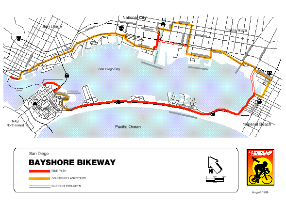
The Bayshore Bikeway is a 26-mile bicycle facility around San Diego Bay. Planning for the Bikeway began in 1975 with a $24,500 feasibility study conducted by Caltrans. That plan envisioned 11.3 miles of bicycle paths and 14.2 miles of bike lanes and bike routes providing convenient and scenic bicycle transportation around the bay. [1]
In 1976, National City received a $50,000 Transportation Development Act (TDA) allocation from SANDAG to widen the Chollas Creek Bridge on Harbor Drive, the first project on the route. The following year, the Bay Route Bikeway Steering Committee was formed by the County of San Diego, and the cities of Coronado, Imperial Beach, Chula Vista, National City and San Diego. As a result of their efforts, the state legislature passed SB 283, providing approximately $1 million for construction of the Bikeway. By 1983, nearly $1.5 million in local TDA and state funds had been expended to construct portions of the Bikeway on old railroad right of way along the Silver Strand in Coronado and on Harbor Drive in the City of San Diego.
The first connection between Coronado and San Diego was via bike racks attached to transit buses. In 1987, service on the San Diego-Coronado Ferry became available. The next major improvement came when the San Diego Port District constructed a bicycle path from Glorietta Boulevard, under the Coronado Bay Bridge to Tidelands Park in Coronado. The Port District extended this path north to the Coronado Ferry Landing in 1993.
In 1989, the San Diego Association of Governments established the Bayshore Bikeway Policy Advisory Committee to promote improvements to the Bikeway. The Committee consists of an elected official from the County of San Diego and each of the five cities around the Bay. The Committee also includes participation by representatives from affected public agencies such as the San Diego Unified Port District and the Metropolitan Transit Development Board, the bicycling community, and other interested members of the public.
A number of projects have been complete as a result of the committee's efforts. In 1993, the Port District extended the Tidelands Park section of the path to the ferry landing. In January 1997, the City of Imperial Beach extended the Silver Strand section of bike path eastward along the bayfront from 7th Street east to 13th Street. This 1.2-mile project was constructed primarily within the old Coronado Branch of the San Diego & Arizona Eastern railroad right of way and will eventually be part of a bayfront linear park. The cost of the project was approximately $240,000 and was funded by SANDAG with TransNet bicycle funds. Most recently, Caltrans completed a connection between the bikeway at Pepper Park in National City and the Sweetwater River Bikeway. This path section passes under I-5 and the San Diego Trolley line at SR 54, allowing cyclists to ride east to Plaza Bonita.
Currently, approximately 10.5 miles of bicycle paths are in use on the Bikeway. The rest of the facility consists of on-street sections designated as either bicycle lanes or bicycle routes.
The original bikeway plan identified interim facilities on local streets for portions of the route. Two of these "interim" facilities still in place today are at the south end of the Bay between Imperial Beach and Chula Vista, and across the Sweetwater River. Replacing these routings has been the main focus of the Bayshore Bikeway Committee.
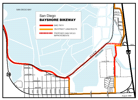
| Sweetwater River Crossing. This project will provide a much-improved crossing of the Sweetwater River between Chula Vista and National City. The project will eliminate a section of the current route where cyclists must travel east from the bayfront to cross the river on National City Boulevard. This routing includes travel on several busy streets that do not adequately accommodate bicycles. The new alignment will bring the route back to the Bay within a right of way reserved for bicycles and pedestrians and will reduce travel distance by more than two miles. The project is divided into two phases. Phase I was the extension of the Sweetwater River bike path along the levee to Pepper Park and Tidelands Avenue, completed in the Spring of 1999. Phase II will cross the flood control channel and connect to Bay Boulevard at E Street in Chula Vista. Two alignments are under consideration: one using SDG&E and MTDB rights of way west of the Sweetwater Marsh Wildlife Refuge, and another in the Caltrans right of way adjacent to the I-5 freeway. The eventual alignment and design will have to accommodate the constraints impose by the adjacent refuge and the potential future use of railroad right of way for freight or recreational trains. |
Sweetwater River Project Phase I
Project Length           1.5 miles
Project Schedule:
  Environmental Approval June 1995
  Design Complete        Spring 1997
  Contract Awarded       Nov. 1998
  Construction Complete  April, 1999
Construction Cost             $680,000
Funding Sources:
  Federal TEA                  544,000
  TransNet                     136,000
                            ----------
Total                         $680,000
|
| South Bay. The next major project in the South Bay will be to replace the current routing along Palm Avenue in the City of San Diego. Preliminary design and environmental studies have been completed for an alignment the will extend the path at 13th Street in Imperial Beach to Bay Boulevard in Chula Vista using a combination of MTDB railroad right of way and adjacent berms that are part of the salt extraction operation. From the point of view of the commuting bicyclist, this is an optimum alignment because it the most direct route between Imperial Beach and Chula Vista. The City of San Diego is lead agency for this section. They will be responsible for the environmental document and final design. Right of way agreements with the Port District, the State Lands Commission, and MTDB have been negotiated, and final design is scheduled to begin in the Spring of 2000. |
Salt Works Project Statistics
Project Length           1 mile
Project Schedule
  Environmental Approval Spring 2000
  Design Complete        Spring 2000
  Contract Awarded       Fall 2000
  Construction Completed Winter 2001
Estimated Cost           $1.5 million
Funding Sources:
  TransNet                  $  100,000
  Federal CMAQ               1,239,000
  State Matching Funds         161,000
                            ----------
Total                       $1,500,000
|
Harbor Drive Improvements. The current Bayshore Bikeway north of National City consists almost exclusively of bike lanes on Harbor Drive. The 32nd Street Naval Station and a variety of bayfront industries prevent construction of a bicycle path along the waterfront. The east side of Harbor Drive is primarily railroad right of way for freight and light rail. Bike lanes can be effective bicycle commuting facilities, but these bike lanes are adversely affected by a number of at-grade railroad crossings, deteriorating pavement, and encroachments from parked cars. The City of San Diego has conducted a corridor improvement study from National City to downtown San Diego. The study inventoried need maintenance and capital improvements to the bike lanes that the City of San Diego will be addressing through their street maintenance and capital improvement program.

[1] Caltrans' Highway Design Manual designates three classes of bicycle facilities: Class I bike path consisting of a paved path within an exclusive right of way, Class II bike lanes consisting of signed and striped lanes within a street right of way, and Class III bike routes, which are preferred routes on existing streets, identified by signs only.
03/21/2000