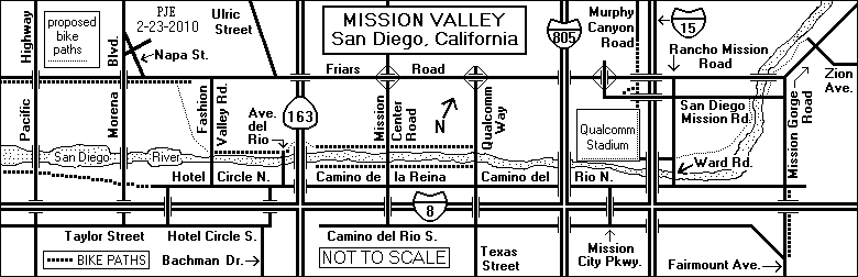
If you want to print out this map, the sideways version may fit better on standard paper.
Most of central San Diego lies on a plateau about 350-400 feet above sea level. The westward-flowing San Diego River has carved a valley roughly one mile wide and seven miles long through the plateau. It has long been called Mission Valley because Mission San Diego de Alcala, the first of the California missions, is located near the east end of the valley.
For recreational bicyclists, Mission Valley is a place to ride. For
bicyclists traveling through the area, especially those going north or
south, it is an obstacle to be crossed or avoided.
2. East-West Bike Routes
There are two principal east-west bike routes through Mission Valley.
Friars Road is the simplest route, since it runs the entire length of Mission Valley. It has bike lanes in most places. However, the traffic on Friars Road is fast and heavy, and free right turn lanes make it difficult to cross Highway 163, Mission Center Road, Qualcomm Way and Interstate 15 safely.
There is no direct connection between Friars Road and the Murphy Canyon Bike Path. However, you can reach the path readily by turning off onto San Diego Mission Road at the interchange just north of the Qualcomm Stadium parking lot. Follow San Diego Mission Road east, and turn left into a small side street before reaching the bridge over Interstate 15. A path at the end of the side street will take you to the bike path.
A route favored by more conservative bicyclists runs alongside Interstate 8. Here are the directions for eastbound bicyclists:
A new bike path, which was opened in 2009, offers a slightly different route. Enter the bike path from Pacific Highway, just south of the San Diego River. Follow it east to Hotel Circle Place. Then follow Hotel Circle Place to its junction with Hotel Circle North. Follow Hotel Circle North to Camino de la Reina. Turn left on Camino del la Reina and proceed east as described above.
Camino del Rio South is fairly hilly in spots and is usually not
the east-west route of choice for bicyclists. There is no connection
between Camino del Rio South and Hotel Circle South.
3. Routes out of Mission Valley
Leaving Mission Valley on the north, south or east side requires an uphill ride, although some routes are much steeper than others.
There are three main routes to the south:
Mission Gorge Road follows the San Diego River east all the way to Santee. It has bike lanes in some places, and there are no significant hills near Mission Valley. (There are some near Santee.)
There are four main routes to the north:
There are three routes out of Mission Valley to the west:
Pacific Highway is part of a major north-south bike route west of
Mission Valley. See also
Bicycling on Old U.S. 101. It intersects Taylor
Street and passes over Friars Road. There is a little sidewalk and path
leading from the north side of Friars Road up to the east side of
Pacific Highway.
4. Crossing the San Diego River
Like most rivers in the semi-arid climate of San Diego, the San Diego River usually isn't much of a river. However, when heavy rains come, as they did in the El Niño winter of 1997-1998, it can flood some parts of Mission Valley. When this happens, many of the river crossings in Mission Valley become impassible because the bridges are very low. Indeed, some of them are little more than culverts.
This can be a serious problem for bicyclists and pedestrians, because the freeway crossings are not accessible to them.
The Pacific Highway and Morena Blvd. bridges at the west end of the valley are fairly high and are not subject to flooding, as is the Friars Road bridge at the east end.
In central Mission Valley, the Qualcomm Way bridge is the most
likely to remain open, but it, too, may be closed when the river runs
especially high.
5. Bike Paths
For those who prefer off-road but on-pavement riding, Mission Valley has a number of bike paths.
The Murphy Canyon Bike Path is an important link in the Interstate 15 corridor, but it is not a scenic route, because it runs between a freeway and a gasoline storage depot.
A small bike path running just east of Fairmount Avenue takes northbound bicyclists safely over the ramps from northbound Fairmount Avenue to Interstate 8.
There are four bike paths along the San Diego River in Mission Valley.
There is a bike path along the south side of Friars Road west of Fashion Valley Road. It is separated from the traffic lanes by a narrow berm. It is regarded as superfluous by some bicyclists, because Friars Road also has bike lanes.
There are proposals, or at least suggestions, for several new or extended bike paths in Mission Valley:
Regional planners are designing a San Diego River Path, which when
completed will run along the San Diego River from the ocean to Lakeside, and
perhaps farther. Some parts of the path already exist. The Fashion Valley Bike
Path is part of the San Diego River Path, and so is the path on the south side
of the San Diego River between Mission Center Road and Qualcomm Way. The
proposed bike path along the San Diego River between Ward Road and Zion Road
will presumably be part of the San Diego River Path if and when it is built.
6. Schematic Map
If you want to print out this map, the sideways version may fit better on standard paper.
E-mail comments, corrections and additions to the webmaster at pje@efgh.com.
November 28, 1998
Revised February 24, 2003
Revised February 23, 2010