|
|
Reviews of Bicycle Rides in San Diego County, California |
Please e-mail comments, corrections and additions to the webmaster at pje@efgh.com.
Tour de Julian, November 11-12, 2006
Tour of Borrego, March 1, 2003
Borrego to the Sea - January 11, 2003
Tour de Julian - November 3, 2002
Scripps Ranch Old Pro's Bike Ride - July 4, 2002
Alpine Challenge, April 13, 2002
Julian Bike Festival, May 6, 2001
Cuyamaca Mountain Bike Poker Ride, October 1, 2000
Tour de Julian, September 24, 2000
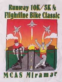
Flight Line Bike Classic - September 23, 2000
Midnight Madness - August 19, 2000
Cycle Eastlake 2000! - May 21, 2000
Tour de Cure 2000 - May 14, 2000
14th Annual Tour de Poway Fun Bike Ride - October 10, 1999
Tour de Julian, September 25, 1999
Flight Line Bike Classic - July 10, 1999
Scripps Ranch Bike Ride - July 4, 1999
Laguna Mountain Road Challenge - June 27, 1999
Low Tide Ride - June 19, 1999
Tour of Borrego, February 28, 1999
Tour de Julian, November 8, 1998
Guacamole Grande - April 19, 1998
Saturn Cycling Tour - March 22, 1998
Subaru Mountain Bike Challenge and Wheelchair Roll - April 26, 1998
Laguna Mountain Road Challenge - June 28, 1998
Julian Tenth Annual Fat Tire Festival - May 2, 1998
Return to Organized Rides Page
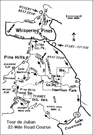
The Julian Fat Tire Festival is an annual event featuring a 22-mile mountain bike ride over rugged and beautiful terrain, and a few other activities. The ride begins and ends at Jess Martin Park on State Highway 79 in Julian, California.
On Saturday, May 2, I was rider number 145. The number of riders is hard to estimate, but it was probably between 150 and 200. The largest bib number that I noticed was in the low 300's, and I didn't notice any bib numbers below 100. The ride promoter later informed me that there were 225 riders.
To make the ride a little more interesting, each rider carried a printed form. At each of five stops, the rider drew a playing card at random from a deck, and a ride official recorded the card on the rider's form. At the end of the ride, each rider had a poker hand.
The weather was nearly ideal for bicycle riding -- cool and partly sunny. Wildflowers were blooming in many places.
We left the park about 9:40 AM, rode the length of Old Cuyamaca Road and then followed State Highway 79 and County Highway S1 to a place where the old California Hiking and Riding Trail crosses S1. There we had to wait in line to draw our first card. The lines at other stops were very short.
The water level in Lake Cuyamaca was higher than I had ever seen it before. El Niño rains had filled it up.
Then we went off-road, following the California Riding and Hiking Trail east and then north through a meadow. This part was easy to ride, because most of it is fairly flat.
Where the California Riding and Hiking Trail meets the Mason Valley Truck Trail, we passed around a locked gate and drew our second card.
Then we coasted down Mason Valley Truck Trail to our first rest and refreshment station, where we picked up our third card. This part of Mason Valley Truck Trail is open to motor vehicles (four-wheel drive recommended), but I didn't see any on it. The road is unpaved and heavily rutted in some places, due to last winter's heavy rains (El Niño again).
Turning left onto Chariot Canyon Road, we coasted most of the way down to Banner. Chariot Canyon Road is mostly downhill, although there were a few places where we had to climb significant grades. Chariot Canyon Road is unpaved, and in better shape than Mason Valley Truck Trail, but there are a few rough spots.
At our second rest and refreshment station, where Chariot Canyon Road meets State Highway 78, we drew our fourth card.
We rode a short distance up State Highway 78, and then followed Old Banner Toll Road up, up, up to Julian.
The ride promoters apparently couldn't get permission to cross private property to reach the lower end of Old Banner Toll Road. We had to lug our bicycles a short distance up a hillside to reach it.
Old Banner Toll Road is not paved, and it's really old. The central portion is still in limited use. However, the upper and lower parts have been abandoned for a long time -- probably more than 70 years -- and have shrunk to single tracks.
Most riders paused to rest at the top of Old Banner Toll Road, although there wasn't any rest and refreshment stop there. It was a difficult ascent. I walked my bike much of the way -- but so did many other riders.
Back on the pavement, we followed Woodland Road, State Highway 78 and State Highway 79 back to Jess Martin Park, where we drew our last card and enjoyed a barbecue with Julian apple pie and ice cream for dessert.
I finished the ride about 1:30 PM. My bicycle odometer showed only 20.3 miles, but the actual distance may have been very close to 22 miles. My odometer doesn't work at walking speed.
The last rider arrived about 2:30 PM, just in time for the awards ceremony. The best poker hand was a full house. My pair of jacks didn't win anything, but I did get a small prize for being one of only three riders over the age of 50. There were also prizes for the worst poker hand, for the youngest rider, for the most unusual attire, and some other things that I can't recall.
I did not attend other events of the day.
I had ridden this course once before, guided by a person who had ridden it in a previous Fat Tire Festival. I could have found my way around it without assistance, despite the fact that the California Riding and Hiking Trail, Mason Valley Truck Trail, Chariot Canyon Road, and Old Banner Toll Road are not marked. There was no course map, but the course was reasonably well marked, and there were ride officials to direct riders at critical turns. As far as I can determine, nobody strayed very far off course.
Philip J. Erdelsky
This was the Second Annual Laguna Mountain Road Challenge, a 50-mile ride starting and ending at Jess Martin Park in Julian, California. A shorter, 22-mile ride was also available.
It's hard to estimate the size of a milling crowd, but I'd say there were about 70 riders. I was rider number 119, because I registered early. The highest bib number that I saw was in the 170's. There were about 50 vehicles in the parking area.
I didn't have to register specifically for the 50-mile ride, but I was determined to ride all 50 miles. Once again, I don't have a head count, but I believe fewer than half of the riders rode the entire 50 miles.
We started promptly at 8:30 AM (give or take a few minutes at most). Emerging from Jess Martin Park, we turned right and followed Highway 79 through Beautiful Downtown Julian. We turned left onto Pine Hills Road and followed the winding but scenic roads through Pine Hills:
Near the foot of Engineer Road, the first sag stop.
Left onto Highway 79 at the foot of Engineer Road.
Right on Highway S1 (Sunrise Highway), and then up to Mount Laguna, a distance of approximately 14 miles. The road doesn't look hilly, but it does have some significant hills. My eyes deceived me, but my legs didn't!
At the 30-mile point, the second sag stop next to the Laguna Mountain Visitor Information Center at Los Huecos Road. I arrived about 12:30 PM and stopped to rest for about 20 minutes.
The ride back to Julian on Highways S1 and 79 is predominantly downhill. In fact, I didn't realize how substantial some of the hills were until I zipped down them at 30 miles per hour.
I got back to Jess Martin Park about 1:20. That's an average speed of about 10 miles per hour, which is normal for me on a long ride.
Most other riders had left by that time, but they still had some Julian pie and ice cream for me.
They ran out of medium-size T-shirts, so I had to put my name on a list. Presumably, they'll be mailing me one.
I didn't get dehydrated, because I drank plenty of water. I took a full bottle, refilled it at both sag stops, and drank it all.
Philip J. Erdelsky
The weather was fine, the flowers were blooming, and the ride was -- a challenge, that's for sure.
There were 5-mile, 10-mile and 14-mile mountain bike rides. I signed up for the 14-miler as rider number 753.
I can't begin to estimate the crowd size, because a substantial part of the crowd apparently came and left while I was out on the trails.
I had hiked from Old Mission Dam up to North Fortuna Mountain the day before, so I knew the way pretty well, at least that far. The hill leading up to the saddle point between North and South Fortuna Mountain is a killer, even on foot. As far as I can tell, nobody rode all the way up -- or all the way down. We all got off and walked our bikes. The steepest grade was about 36%, according to my clinometer. That's steep!
From North Fortuna Mountain both the 10-mile and 14-mile rides went down the northwest side and into the canyons to the west. This area is honeycombed with dirt tracks. I was unable to follow the official course, despite some familiarity with the area.
I went off course and returned to Mission Day via Oak Creek, as did a number of other riders. Somebody had moved the course markers.
When I got back to the starting point, the crew were packing up and getting ready to leave. However, they left a bag of bagels on a picnic table, so we latecomers didn't have to go hungry.
If you want to ride in Mission Trails Regional Park, download a map from their website at www.mtrp.org. It will be as good as the one they gave us. Then just ride around the place. You'll get as good a ride as we did.
Philip J. Erdelsky
Saturn Cycling Tour - March 22, 1998
I suppose Saturn makes good cars. They certainly organize good bike rides. They even had a website for the event, which is still up as of the date of this writing (May 12, 1998). The address is www.saturnsandiego.com/SCT/sct.html.
I registered for the 50-mile ride. However, I also rode from my home in North Park to Bonita Cove and back, which added about 18 miles more. That made it my longest ride ever, but for some reason it wasn't the most tiring.
We started promptly at 7:15 AM and rode around the south and east sides of Mission Bay, up Rose Canyon and through the UCSD campus to the first sag stop. We continued north on North Torrey Pines Road and turned east on Carmel Valley Road.
There was only one killer hill on the course -- Calle Cristobal.
Another sag stop on Black Mountain Road in Mira Mesa marked the highest point of the course. From there it was mostly level or downhill.
We avoided that gigantic sinkhole on Murphy Canyon Road by detouring onto Ruffin Road. The course map labeled it "El Niño Sinkhole".
We followed the usual bike route through the Qualcomm Stadium parking lot to Mission Valley. From there it was smooth riding through Mission Valley all the way back to Bonita Cove and the post-ride festivities. I arrived about noon.
It hardly felt like 50 miles, but my odometer said otherwise.
The course map and description were adequate, the course was well-marked, and as far as I can tell, nobody got lost. Of course, I was quite familiar with most of the course.
I stayed for the barbecue, but I had to leave about 1:00 PM. I wish I could have stayed a little longer. Maybe next year I will.
Philip J. Erdelsky
The 50-mile Guacamole Grande ride is rated "difficult" by the Bicycle Ride Directors' Association. But I registered for it anyway, because I knew the 20-mile ride would be too easy for me. I was rider number 129.
They didn't give us a map of the 50-mile course, but they did give us a complete set of directions, with all the turns and distances. That came in handy, because some of the course marking signs were missing. I managed to stay on course all the way.
We left Fallbrook on eastbound route S17, and then turned north on Ranger Road. We crossed I-15 for the first time on Mission Road, and then followed old Highway 395 north to Rainbow and our first rest stop.
This being the Guacamole Ride, we had chips and guacamole dip at every rest stop, in addition to the usual fare.
Then we followed Rice Canyon, Couser Canyon and Lilac Roads south, encountering some real hills, and also some great views.
Some riders missed the right turn onto West Lilac Road. I stopped to consult the directions and made the turn.
I had ridden through here before -- in a heavy rain. This time the weather was good. We coasted down Circle R Drive to our second rest stop at Chanpagne Blvd. and Gopher Canyon Road.
Then it was uphill again on westbound Gopher Canyon Road, a loop through the San Luis Rey Downs Country Club, and back to the final rest stop on Camino del Rey near Old Highway 395.
Maybe I was just tired by this time, but the next hill climb seemed to be the worst of the course. It's on Old Highway 395 where it crosses I-15 just south of the lofty Old Lilac Road bridge. On the north side of the bridge is a rather wide expansion gap in the pavement. I was going uphill -- very slowly -- so it didn't bother me much, but it can really give downhill bikers quite a jolt!
From there, the route to the finish line was fairly direct -- west on Highway 76, north on Grid Road, and west on route S15. There are a few hills on route S15 in downtown Fallbrook. They're small hills, but they looked big to me, because I was quite tired -- and a little dehydrated, too.
The finish line at Mission Road and Alvarado Street was right next to the Avocado Festival. I didn't attend that, because I wanted to get back to San Diego in time to see the Earth Day Fair in Balboa Park. (Who planned two major festivals on the same day?)
Like many other riders, I rode the mile and a half back to Fallbrook High School. I didn't want to wait for a shuttle. It was a gentle downhill ride most of the way.
Yes, I drove back to San Diego. However, I did ride my bike a little farther -- to Balboa Park, where I took advantage of the San Diego County Bicycle Coalition's free bike parking at the Earth Day Fair.
Philip J. Erdelsky
The r*** was falling when I arrived at Jess Martin Park at 7:27 AM, and there was a moderate wind. Unfortunately, the r*** kept falling, and the wind kept blowing, until after the Tour de Julian was over.
It had to happen eventually. According to the promoter, this was the first time in the eleven-year history of the ride that they had bad weather.
But the show must go on!
Shortly after 9:00 AM, some fifty-odd mountain bikers left the park for the 22-mile ride through Chariot Canyon and Banner. See the review of the Julian Tenth Annual Fat Tire Festival for a description of the course. I was surprised that the number was so large, considering the less-than-ideal conditions. I was even more surprised to learn later that at least one of the mountain bikers had registered that morning!
I didn't get a good count for the 32-mile riders. I saw six riders leave. The actual number wasn't much more than that.
I had originally planned to to the 32-mile ride, but decided not to attempt it. I don't ride much in bad weather, and I don't have much in the way of protective clothing.
About 9:25 AM, the 17-milers -- all six of us -- left Jess Martin Park. I was number 145. The ride to Downtown Julian on Highway 79 was actually the hardest part of the ride. The wind was blowing us sideways, and I found it hard to stay upright and on course. We rode together through Downtown Julian and down Highway 78 to Pine Hills Road.
With wet brakes, I was quite conservative about my downhill speed. The other five riders got ahead of me, and I made the left turn onto Pine Hills Road alone.
I passed one of them on Pine Hills Road. He had a f*** tire. After the ride, he told me he had walked back to Jess Martin Park. He didn't have a spare inner tube, and he couldn't patch a tube in the r***.
I caught up with the other four at the intersection of Deer Park Lake Road. They were in doubt about the route, so I dug out my copy of the course map and showed them the way. Another rider decided to turn back.
I led the pack until the turnoff at Eagle Peak Road.
Along Eagle Peak Road, I got behind the other three riders and didn't see them again until we got back to Jess Martin Park.
I followed the course as marked. The little yellow arrows marking the way were soggy, but they were all there. The pines gave some shelter from the wind, but the r*** continued.
At the sag stop on Deer Lake Park Road, I told the attendant that I was the last 17-miler. He told me I was the first rider to arrive! I wondered where the other three had gone.
As I entered downtown Julian, I decided not to go to the Winery, but headed straight back to Jess Martin Park.
I arrived at 10:45 AM, after having ridden 13.47 miles, according to my bicycle odometer.
The other three 17-milers arrived later. For some reason, they had turned right on Boulder Creek Road and had done most of the 32-mile ride in reverse! I don't know how that happened. The signs at that corner were soggy and drooping, but they all pointed the right way.
Except for the weather, it was a good ride. And the weather is the one thing that nobody can predict or control. We can only hope and pray and take our chances. But with ten good years and only one bad one, the odds are pretty good. I think I'll be back next year.
Philip J. Erdelsky
Tour of Borrego, February 28, 1999
The weather was perfect in Borrego Springs, sunny with very little wind, and over 400 riders participated in the Tour of Borrego, a 22-mile or 38-mile road ride around beautiful Borrego Valley. I was rider number 233, and I rode all 38 miles.
We set out at 9:35 AM from the Palm Canyon Resort, and rode west along Highway S22 (Palm Canyon Drive) through the heart of downtown Borrego Springs to Christmas Circle.
There we turned south and followed Borrego Springs Road almost all the way to Highway 78.
Just before reaching Highway 78, Borrego Springs Road dips to cross a wash. The hills on each side of the wash are fairly steep -- about 12 percent -- but they aren't very long, and they are the only significant hills in the whole course.
We turned around there and rode back to the first rest stop near the intersection of Borrego Springs Road and Yaqui Pass Road. According to my odometer, this was the halfway point.
(The 22-mile ride did not include the ride out to Highway 78 and back.)
Then it was north on Yaqui Pass Road, Rango Way and Borrego Valley Road (which appeared to be a single road) to Highway S22 (Palm Canyon Drive).
The 22-mile ride continued north on Borrego Valley Road, but the 38-milers turned right and followed Highway S22 past the airport.
We turned left onto Henderson Canyon Road and followed it past the grapefruit fields and another rest stop. It veered left and became Borrego Springs Road.
The last few miles ran through a residential area:
I returned to the starting point at 12:25 PM. That's an average of 13.4 MPH, better than my usual speed, but there were practically no hills on the course.
Closing ceremonies lasted about an hour. As I returned to my truck about 1:30 PM, I noticed that there were still a few riders coming in.
I had to leave, having other commitments in San Diego that evening. For those who could stay, a visit to nearby Anza Borrego Desert State Park would have been an excellent way to spend the rest of the day.
I was a little disappointed to see the usual orange slices at the rest stops. In Borrego Springs, they should have served grapefruit.
Philip J. Erdelsky
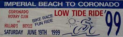
Although I registered for the Low Tide Ride in advance, I showed up at the starting point (YMCA Camp Surf at 106 Carnation Ave. in Imperial Beach) quite early, about 7:13 AM. They were issuing bib numbers sequentially. I got number 1.
Last year there were about 120 riders. This year there were more: the highest bib number I saw was 135.
Parking at Camp Surf was a little tight this year, because the campground was open and campers occupied most of the parking lot. There seemed to be room enough for everyone, although some latecomers had to park along the access road.
It was a cool morning, with the usual coastal cloudiness. Ideal for bike riding.
For those riders who needed it, a chain lube was available at the starting point. (See photograph.)
The competitive riders left about 8:30 AM, maybe a few minutes later. The fun riders (including me) left at 8:43 AM.
Riding a long distance on wet sand was something new to me. It wasn't too bad -- sort of like riding up a gentle hill all the way to Coronado. The sand near the water was reasonably firm everywhere except right next to the jetty at the Hotel Del Coronado. I had to get off and walk my bike for a short distance.
I arrived at the finish line (at Sunset Park at the intersection of Ocean Blvd. and Ocean Drive in Coronado) at 9:44 AM, and my bicycle odometer said I had gone 7.96 miles, for an average speed of about 7.8 MPH.
I picked up my T-shirt, drew for a prize, and got lucky -- I won a Sunday brunch for two at the Loews Coronado Bay Resort. Then they washed the sand off my bike and re-lubricated the chain. (See photograph.)
I rode back to Imperial Beach along the Silver Strand Bike Path, which runs right next to the east side of Highway 75.
On the whole, the Low Tide Ride is a fairly small organized ride, but one that is definitely worth doing. There's no other ride in San Diego County quite like it.
Philip J. Erdelsky
Crown City Cyclists dominated the Low Tide Ride "Racer Class". The first six positions were all members of the Coronado Cycling Club.
Michael McLeod won first place in the Men's division in a photo finish with second place finisher Zeke Mazur. The winning time was 32:48.
The top female competitor was Cia Banks with a time of 35:19.
The Low Tide Ride is a bike race/ride from Imperial Beach to Coronado on the beach during a very low tide. This is the second year that the Coronado Rotary has sponsored this unique event. All proceeds go to Rotary efforts to eliminate polio in the world.
This year's event attracted about 140 participants, most of them in the "Fun Ride Class".
The ride starts at Camp Surf YMCA in Imperial Beach and finishes at Sunset Park in Coronado.
The top eleven finishers in the "Race Class" were as follows:
The youngest finisher was Timothy Dawson, age three. The finisher with the least appropriate footwear was Jeanne Latoures.
Laguna Mountain Road Challenge - June 27, 1999
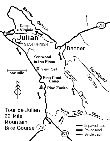
This was the Third Annual Laguna Mountain Road Challenge, a 50-mile ride starting and ending at Jess Martin Park in Julian, California. A shorter, 22-mile ride was also available. Last year, I rode all 50 miles. (See review.) This year, I rode only 22 miles.
As nearly as I can tell, the ride was about the same size it was last year (76 riders). The highest bib number I saw was 167, the lowest is 100.
We started about 8:37 AM. The course was the same as last year.
Emerging from Jess Martin Park, we turned right and followed Highway 79 through Beautiful Downtown Julian. We turned left onto Pine Hills Road and followed the winding but scenic roads through Pine Hills:
Then we began a 4.5-mile climb. There was a false summit after 3.5 miles, and then another mile of climbing, including the steepest parts of this ascent.
Near the foot of Engineers Road, the first sag stop. (See photograph.)
Left onto Highway 79 at the foot of Engineer Road.
At the intersection of Highway S1 (Sunrise Highway), I continued straight ahead on Highway 79 back to Jess Martin Park. The 50-mile riders turned right and rode about 14 miles up, up, up to Mount Laguna.
I got back to Jess Martin Park at 10:39. That's an average speed of about 10 miles per hour, which is normal for me on a long ride.
There wasn't any post-ride entertainment (unlike the much larger Fat Tire Festival), but there was Julian pie and ice cream.
Philip J. Erdelsky
Scripps Ranch Bike Ride - July 4, 1999
This event offers 50-mile, 28-mile and 12-mile rides. Normally, a 50-mile ride would be about right for me, but I planned to ride from home to and from the event, adding another 32 miles. So I registered for the 28-mile ride.
I got up early, as I usually do, and set out for the starting point at 5:43 AM.
One of the principal benefits of bicycle travel is that bicyclists often see, hear and notice things that motorists don't. Along the way, I stopped briefly on Kearny Villa Rd. to pick up a cell phone that was lying in the northbound bike lane. It seemed to be damaged slightly but still working. It had a brand name (Nokia), but no other identifying marks. I know little about cell phones, having used one only briefly two years earlier. I put it in my pack and continued. I would find out later how to return it to its owner.
I arrived at the starting point at Scripps Ranch Blvd. and Hibert St. (Thomas 1209 F3) about 7:00 AM, just before the 50-mile ride began.
I usually try to estimate the number of riders by counting bib numbers. The lowest bib number I saw was in the low 1300's, and the highest was 1747. The total number of riders was probably more than 300. (I was number 1545.)
The 28-mile ride started promptly at 7:30 AM. The course was fairly well marked by bright orange signs, although there was at least one turn without a sign, or at least I didn't see it. However, the printed course description was clear enough that I could have followed it even if the course had not been marked.
We went west on Mira Mesa Blvd. and the north on Black Mountain Road. At the interchange with Highway 56, we turned into the "Ted Williams West" bike path, as I call it, and followed the path, Azuaga Street, and the "Ted Williams East" bike path to the interchange with Interstate 15. (See MIRA MESA AND RANCHO PEÑASQUITOS on my Red Routes page).
We crossed Interstate 15 and turned north on Rancho Carmel Drive.
They were just setting up the first SAG stop (or aid station, as they called it) in front of the Postal Center on Rancho Carmel Drive when I arrived.
Continuing north on Rancho Carmel Drive, we turned left onto Carmel Mountain Road and then left again onto Camino Del Norte.
We followed Camino Del Norte to its current end, and the turned right onto Camino San Bernardo.
Then we turned right on Rancho Bernardo Road and followed it east through the heart of Rancho Bernardo.
We turned south on Pomerado Road for the long haul back to Scripps Ranch. The SAG stop at Twin Peaks Road was fully operational when I arrived, and it even had portable toilets available.
Pomerado Road from just south of Scripps Poway Parkway to the intersection with Spring Canyon Road and Cypress Canyon Park Drive is a notorious killer hill. A few local residents stood on the sidewalks to cheer me and other riders on as we pedaled slowly up the hill.
We followed a somewhat circuitous route to the finish line at Hoyt Park, probably to avoid the route of a Fourth of July Parade through Scripps Ranch.
I crossed the finish line at 9:38 AM, and my bicycle odometer read 26.85. That's an average speed of a little more than 12-/12 miles per hour, about par for this kind of ride, at least for me.
The Scripps Ranch Old Pros event also includes a footrace, although I didn't know that until I arrived at the finish line and heard them announcing the names of the winners.
Hoyt Park isn't shown in the Thomas Guide. It's on the south side of Canyon Lake Drive near its east end (Thomas 1209 H4). Aviary Drive runs along the crest of a hill to the south of the park. I could just see the tops of some of floats as the parade passed by.
Closing ceremonies included the usual event T-shirt, some snacks and free beer for participants at least 21 years old.
Another rider who had a cell phone of her own told me what to do with the one I found. I simply dialed 811 on it to call the service provider. The Air Touch representative who took the call told me to turn it over to the nearest Air Touch dealer, who would be able to trace the owner.
When I left the park at 12:05 PM, the parade route was still closed off, so I had to follow a somewhat circuitous route out of Scripps Ranch, one that had more ups and downs than I would have wanted. But I eventually got back to Pomerado Road. From there, finding my way home was easy. I commute to and from Mira Mesa by bicycle once a week and know the route very well.
Philip J. Erdelsky
Flight Line Bike Classic - July 10, 1999
The last time I participated in this ride, Miramar was still a Naval Air Station. But under the new Marine Corps management, the Flight Line Bike Classic is still essentially the same event.
I registered in advance, and was issued bib number 1158. I couldn't use bib numbers to estimate the number of riders, as I usually do, because it appears that bib numbers were not issued in numerical order. My best estimate of the number of bicyclists is at least 1000, which was obtained by eyeballing the crowd. In any event, it was a pretty big ride.
The 10-mile course goes around the runways twice. The 20-mile ride goes around the same route four times. That's enough for most people. Any more, and it would get rather boring. As it is, the ride is roughly like riding around a very large velodrome.
The event also includes 5K and 10K footraces, which begin much earlier and are finished before the bike rides begin. They post the results next to the stage and also on the Internet at runresults.com.
I believe at least one man may have done both a footrace and a bike ride. He was wearing two bibs.
The nominal starting time for both 10-mile and 20-mile rides was 9:30 AM. There were so many riders that they had to start in stages. The first stage left the starting line at 9:23. I was in the second stage. The last stage probably left about 9:30. See photograph.
Some riders stopped to look at and inside several airplanes parked on the runways next to the course.
Post-ride entertainment was definitely up to snuff, brought to us by Bare Bones Rock and Blues and Classic Rock and Z-90 90.3 FM. Post-ride refreshments included beer and pizza. However, there was practically no shade, and it was a hot, sunny day. If you do this ride, be sure to pack and use plenty of sunscreen.
In addition to riding the 20-mile course, I also rode my bicycle from home to this event and back, which added another 28 miles.
Where else can you ride on smooth, level pavement for 20 miles without stopping or even slowing down? That's what I did, at an average speed of slightly more than 15 miles per hour. It's the most unique feature of this ride, and one that makes it worth doing.
Philip J. Erdelsky
Return to top of page
Tour de Julian 1999 - September 26, 1999

Last year's Tour de Julian was something of a disappointment because it rained (see review.), so this year the promoter held it earlier in the season, hoping for better weather.
The decision paid off. The weather was very good, despite predictions of extreme heat. It was warm and sunny, but I stayed well hydrated and enjoyed the ride.
I arrived at Jess Martin Park early, about 7:30 AM, after having driven about an hour and twenty minutes and 57 miles from San Diego.
Something new this year: Bike USA was an official ride sponsor, and they had a mechanic there to make minor repairs.
There were at least 210 registered riders, maybe more, judging from the bib numbers I saw. Although this ride offers two rode rides and one off-road ride, the fat tires far outnumbered the skinny ones.
I did the 32-mile road ride this year. That's the only one I had never done before, although I had ridden some of the route in the opposite direction as part of the Laguna Mountain Road Challenge.
We set out a few minutes after the official start time (8:45) and rode south along Old Cuyamaca Road, which parallels Highway 79 and is apparently an older alignment for it, for the first mile. Then we ventured out onto Highway 79.
Some riders missed the turn onto Engineers Road, although the black-on-yellow arrows were clearly visible there and at all other turns on the course. One rider apparently went all the way to Green Valley Campground before she realized she was off course! That's a nice ride, too -- I've ridden that way before.
The course along Engineers Road has what was posted as a six-mile descent, with several hairpin turns. Actually, my odometer registered only about four miles of descent along Engineers Road. At the bottom of the hill, we turned right onto Boulder Creek Road and descended for another mile.
Then it was a two-mile climb up to Pine Hills Rd.
I was thankful for the course markings in the Pine Hills area. The roads are winding, and the street signs can be confusing.
We rode east on Frisius Dr. and north on Deer Lake Park Rd. to the first SAG stop. There I stopped for R&R and did a double take. I saw a "Railroad Crossing" sign, not on Deer Lake Park Rd., but on a private driveway next to the SAG stop. Sure enough, a slightly undersize pair of railroad tracks crosses the driveway there. "What is a railroad doing in Pine Hills?" I asked.
One of the local residents was there to explain it. Years ago, a Walt Disney animator moved to Pine Hills and built the little railroad line as a hobby. The locomotive still works, although it's quite a job to get it up and running, so the tracks don't get much use.
I took a picture of the tracks. Just to show you that the tracks are not standard size, I shot myself in the foot.
The ride back to Jess Martin Park follows the same route as the 17-mile ride, which I did last year. But this year I didn't take a shortcut. I rode out to the Menghini Winery and back.
I returned to Jess Martin Park about noon for some Julian pie and ice cream. My odometer read only 29.78 miles, but that's close enough.
Philip J. Erdelsky
Return to top of page
14th Annual Tour de Poway Fun Bike Ride - October 10, 1999
The 14th Annual Tour de Poway featured four different rides: a 16-mile off-road ride through Goodan Ranch, and 15-mile, 25-mile and 50-mile road rides. I had done the off-road ride several years ago (before I started to write these reviews). This year I registered for the 50-mile road ride.
The ride started promptly at 7:30 AM (give or take a few minutes). It began with a killer hill--a two-mile ascent up Poway Road to Highway 67. I had ridden up that hill before, but I was glad to get it out of the way at the beginning of the ride.
Then we rode up Highway 67 to Ramona, through some parts of Ramona that I hadn't seen before, and then more or less west on Highland Valley Road to the first AID station at the intersection of Highland Valley Road and Archie Moore Road.
We continued west on Highland Valley Road, enjoying some great scenery and some nice, long descents, all the way to Pomerado Road. (I had ridden this road before and knew what to expect.) We followed Pomerado Road and W. Bernardo Dr. to the second AID station at Rancho Bernardo Community Park. At that point, we had completed about two-thirds of the ride.
The route back to the starting point in Poway was somewhat indirect, but quite ridable. (I suspect that this was because a more direct route would have been quite a bit less than 50 miles.)
At 11:25, I passed a photographer from Photo Crazy on Metate Lane. He was taking pictures of riders as they passed. The photographs will be posted on the World Wide Web within 24 hours at photocrazy.com, indexed by the time taken. I'll be looking for mine; if it's good I'll order a copy. This sort of thing has been done before on other rides, but they didn't use the Internet.
P.S. The photograph is reasonably good. Click here to see it.
I arrived back at the starting point at 11:35 AM, and my bicycle odometer read 48.33 miles -- close enough for this kind of event. After all, it's a ride, not a race.
I could hardly believe I had ridden the whole course in only four hours. I had expected it to take closer to five hours, especially with a killer hill to be conquered. But the weather was good, and there were no unfavorable winds.
As I left the park about noon, I noticed that some riders were still coming in, but the banner over the start/finish line had been taken down. I think it should have been left up a little longer.
Next year? I'll probably do one of the other road rides -- one that I haven't done before.
Philip J. Erdelsky
Return to top of page
Tour de Cure 2000 - May 14, 2000
This ride is held each year as a fundraiser for the American Diabetes Association. It features 25K, 50K and 100K rides. (That's about 14 miles, 30 miles, and 62 miles, respectively.)
I registered well in advance for the 100K ride.
The first problem with this ride occurred even before the ride itself. The advance materials, including the mail-in resigtration form, listed the starting point only as "Mission Valley" in San Diego. The American Diabetes Association website said only "San Diego", and the toll-free telephone number said "Leave a message and we'll call you back".
My ride packet arrived only two days before the ride itself. It clearly identified the starting point (the parking lot at Ward's in Mission Valley Shopping Center). If it had arrived only two days later, I probably wouldn't have done the ride. I wonder how many potential riders missed the ride for that reason.
On the upside, registration went fast, and the 100K riders started promptly at 7:30 AM.
We rode up Rose Canyon to the first SAG stop at Doyle Park on Regents Road, and then down to the Sorrento Valley on that little bit of I-5 that's open to bicycles. We rode north on Sorrento Valley Road. (Yes, the northern mile is still closed to cars.) Then we rode north on El Camino Real and west on Via De La Valle to the Coast Highway. (This is a place where I would have preferred not to ride. The bridge on El Camino Real just south of Via De La Valle is so narrow that I had to take the lane.)
By this time, I was out of sight of other Tour de Cure riders. I rode north up the coast, and then east on Encinitas Blvd., south on El Camino Real and west on Manchester Ave. back to the coast.
I followed the standard coast route all the way back. At the second SAG stop, at the top of the notorious Torrey Pines grade, I saw a few other Tour de Cure riders again.
One of the riders I met near the end of the ride had a special interest in this ride: he is a diabetic.
I returned to Mission Valley at 12:30 PM, having averaged a slightly slow but reasonable 12.4 MPH, but just in time for lunch. Apparently, most of the other riders had already returned and left. By about 1:15 PM the crew had everything packed up.
After lunch and a good rest, I was ready to conquer Texas Street on the way home.
Next year, if I do this ride at all, I will probably opt for the 25K ride. I won't see as much of the San Diego area, but I will see more of the ride festivities.
Or maybe I'll just send my check directly to the American Diabetes Association.
Philip J. Erdelsky
Return to top of page
Cycle Eastlake 2000! - May 21, 2000
Cycle Eastlake 2000 offered 12-, 25- and 50-mile rides. I opted for the 50-mile ride because it went where I had never bicycled before. The 12-mile ride was too short. The 25-mile ride stayed in familiar territory.
The 50-mile ride started promptly at 7:30 AM. It appears that roughly 100 riders rode all the way to the turnaround point for this ride.
The ride first went through Eastlake Greens, and then to the ARCO Olympic Training Center via Olympic Parkway, which is apparently not fully open.
On Olympic Parkway, I and several other riders had to pause as a dog led three cattle across the road. Apparently, some of the ranches in the neighborhood are still in business.
We rode down Wueste Road and turned around at the entrance to Lower Otay County Park. This little loop was apparently added to the 25- and 50-mile rides to make them the right lengths.
The main part of the 50-mile ride went east on Otay Lakes Road, and then east on Highway 94 to Barrett Junction. There was a water stop at Thousand Trails Trailer Park on Otay Lakes Road, about 2.4 miles west of Highway 94, and another at the 50-mile turnaround point at Barrett Junction.
The 25-mile riders turned around at Highway 94.
The traffic and the hills on this part of Highway 94 aren't as bad as I had believed. The worst hill was an 0.8-mile climb on the return trip just west of Barrett Junction. It seemed like more than 0.8 miles, but my odometer doesn't lie very often.
I finished the ride at 11:20 AM, after having ridden 48.23 miles, according to my bicycle odometer. I skipped the Wueste Road loop on the way back, as did many other riders.
You can do this ride without support. There is a store at Thousand Trails and a cafe at Barrett Junction where you can get refreshments.
In order to participate in this ride, I had to pass up the Julian Bike Festival. The two ride directors should coordinate their schedules more carefully. They might attract more riders to both rides.
Philip J. Erdelsky
Return to top of page
Midnight Madness - August 19, 2000

Cyclists gathered in Downtown San Diego late in the evening of Saturday, August 19 for the 27th Annual Midnight Madness Ride, sponsored by the Uptown Optimist Club and American Youth Hostels. The ride itself began at midnight, so was actually on August 20, but ride promoters in past years have assured me that there has never been any mistake about the date. Presumably nobody showed up 24 hours early!
The ride started and ended at the County Administration Building parking lot, just north of Ash Street and between N. Harbor Dr. and Pacific Highway. There were about 2000 riders, bearing numbers from a little more than 2000 to a little more than 4000. I was number 2356. I put fresh batteries in my bicycle headlight and rode in from my home, a little more than four miles away.
Starting at the very stroke of midnight, all 2000 of us rode up N. Harbor Drive to the vicinity of the airport, made a loop around Harbor Island, and then continued up N. Harbor Drive and Scott Street to Shelter Island. After a loop around Shelter Island, we rode along Rosecrans Street to Old Town. Then we turned right and followed Congress St., San Diego Ave., Noell St., Hancock St. and Kettner Blvd. back to Downtown San Diego. A right turn onto Harbor Dr. took us back to the starting point, where we joined one of four lines for goodie bags and snacks.
This ride could be done only at night; it would cause horrendous traffic jams in the daytime, especially near the airport, where the riders often occupied all of the traffic lanes and moved right only to let the occasional motor vehicle pass.
The nominal ride length was 20 miles; my odometer showed about 18.5. I finished the ride at 1:20 AM. I might have inadvertently lopped about a tenth of a mile off the course by taking a shortcut on Shelter Island. The course map was tiny and hard to read.
At 2:30 AM judging was held for prizes in two categories: the best bicycle lights and the best costume. There were three prizes in each category and only a handful of contestants.
This is one of the oldest major organized rides in San Diego; it may even be the oldest. It is also one of the largest, if not the largest. The course is fairly short and almost completely flat, which means just about any bicyclist can manage it. The only disadvantage is the ungodly hour, especially for strongly diurnal people like me.
Riding back home about 3:30 AM on well-lit but mostly deserted main streets was a new experience for me. Fortunately, my headlight batteries held out until I got home.
Philip J. Erdelsky
Return to top of page
Flight Line Bike Classic - September 23, 2000
Last year, this ride was held on a hot, sunny day in July. This year it was held in September, and the heat wave broke just in time. It was cool and cloudy the morning of the ride. There was a little rain the night before, and there was a chance of rain in the official forecast. I took a jacket, but didn't need it. I felt just a few drops during the ride itself.
The ride went pretty much as it did last year. See last year's review for details.
Although 10-mile and 20-mile rides were planned, the emcee didn't mention them at the beginning of the ride. He just said we had an hour and a half to ride around the five-mile course as many times as we wanted. I rode around it four times, as I did last year.
Philip J. Erdelsky
Return to top of page
Tour de Julian 2000 - September 24, 2000
This year's Tour de Julian was pretty much the same as last year's. (See the 1999 review.) I rode the 32-mile course, as I did last year.
The weather was quite good, although it was a little windy in spots -- especially on Frisius Road and Farmer Road.
Like many railroads before it, the Pine Hills Railroad is being abandoned. The "railroad crossing" sign and the tracks near Deer Lake Park Rd. have been removed. However, a local resident assured me that the railroad isn't completely gone. Maybe next year we'll get to see some of it.
Philip J. Erdelsky
Return to top of page
Cuyamaca Mountain Bike Poker Ride, October 1, 2000
This was the tenth annual Cuyamaca Mountain Bike Poker Ride, but it was the first one I knew about. It is sponsored by the Cuyamaca Rancho State Park Mountain Bike Assistance Unit.
Advance publicity gave the start time as "8:00 to 9:30 AM". I arrived well before 8:00 AM, although I had registered in advance. I tried to "follow the signs to the parking area". It was fairly easy to find, although there weren't many signs to follow. It was a little chilly at first, but by 8:00 AM it had warmed up. The weather during the ride was excellent.
There were no numbered bibs or other things to identify riders. T-shirts cost extra. I decided to pass, because I already have more T-shirts than I can use. I was given a lunch ticket and one raffle ticket for the post-ride drawing. Additional raffle tickets were on sale.
A map of the ride route was posted next to the registration tables. No maps were distributed to riders.
I started at 8:18 AM with one of the first groups of riders. The lack of a precise start time was good in one way -- it prevented massing of riders at the beginning of the ride.
There were supposed to be signs marking the route, but some turns were unmarked. Nevertheless, I managed to stay on course. I had ridden or hiked most of the course before.
I walked my bike most of the way up Soapstone Grade (see photograph), and so did most other riders. Along the rest of the ride, I had to walk my bike in only a few of the steepest or roughest places.
Along the way, there were five stops, where I picked up five "cards" to make up my poker hand. Actually, I drew a card at each stop, and ride officials wrote the rank and suit on my tally sheet.
I did not ride the optional extra six-mile section. Riders who did got a sixth card.
My poker hand was a complete bust -- not even a single pair.
I returned to the parking area at 11:08 AM. My odometer read 17.01 miles. The course was probably a little longer than that, because my odometer doesn't register at walking speed.
Spaghetti lunch was served at 11:30. Awards began at 1:30 PM and lasted for nearly an hour. The top poker hand was four queens, and a straight was the lowest hand to be awarded a prize. Then raffle tickets were drawn for more prizes. Neither my poker hand nor my single raffle ticket won anything, which was not surprising.
Additional information about mountain biking in Cuyamaca Rancho State Park is available at www.cuyamaca.statepark.org.
Philip J. Erdelsky
Return to top of page
Julian Bike Festival, May 6, 2001
This ride was called the Julian Fat Tire Festival when I rode it in 1998. Now they've added a 56-mile road ride to the 22-mile off-road ride. Read my review of that ride before reading further.
I did the off-road ride again. The route was unchanged, but there was no need to drag our bikes up the hillside to reach the Old Banner Toll Road. The property owner apparently cooperated this year.
There wasn't any "poker" game this year, but they still serve Julian apple pie and ice cream, and there's a hill-climbing contest after the ride.
I found the ride somewhat harder than I did in 1998, especially the ascent of Old Banner Toll Road. Maybe I'm just getting too old for that kind of thing. Maybe next year I'll do the 56-mile road ride. That will be very appropriate; next year I'll be 56 years old.
Philip J. Erdelsky
Return to top of page
Alpine Challenge, April 13, 2002
This is only the second year for the Alpine Challenge, and it's the first year I've participated in it. It begins and ends at the Alpine Community Center (actually, a small park) on Alpine Boulevard near the Tavern Road exit from I-8.
There are three rides: the Metric Century (100 kilometers, or about 62 miles), the 30-mile ride, and a 5-mile family fund ride.
The ride is put on by the Kiwanis Club of Alpine.
I arrived at Alpine Community Center in time to see the beginning of the Metric Century Ride at 8:00 AM. (See photograph). That ride is a real challenge, with several thousand feet of ups and downs. I chose the 30-mile ride, which began at 9:30 AM.
We rode east on Alpine Boulevard to the East Willows exit from I-8, then crossed over I-8 and rode west along Willows Road on the other side of I-8, passing right by the Viejas Casino and Outlet Center, one of the principal sponsors of the ride.
We crossed I-8 again at the next interchange and started to backtrack. We turned left on South Grade Road and followed a scenic route through Alpine and Harbison Canyon to the first SAG stop on Dehesa Road, right next to the road leading to the Sycuan Reservation and Casino.
Then it was up, up, up Dehesa Road to a water stop at Japatul Road.
The Metric Century riders turned right and followed Japatul Road and Old Highway 80 all the way to Descanso and back. The 30-mile riders turned left and returned to the Alpine Community Center via South Grade Road and Alpine Boulevard, retracing some of the outbound route.
Course support was terrific. There were police officers or volunteers at every turn to show us the way. And in most cases they stopped cross traffic to let us pass.
I returned to the Alpine Community Center about 12:45 PM. A simple lunch consisting of a hamburger or hot dog, chips and soda was available at the end of the ride for $3.00. For those seeking alternatives, there were several restaurants at shopping centers right next door and across the street. That's something you generally don't get at rides of this kind.
The total number of riders was apparently somewhere between 100 and 200. I estimated the number of riders in the Metric Century and 30-mile rides at 50 each. Only about 20 or 30 riders stuck around for the raffle after the ride. However, it was not necessary to be present to win. In fact, the major prize, a hybrid bicycle, was won by a participant who wasn't there for the drawing.
Philip J. Erdelsky
Return to top of page
Scripps Ranch Old Pro's Bike Ride - July 4, 2002
I did this ride previously in 1999. See the review above.
There were very few changes this year. Even Hoyt Park still isn't in the 2002 Thomas Guide.
There were two things that I did notice.
Instead of riding along the "Ted Williams West" bike path, nearly all riders rode along the shoulder of Highway 54. Probably the first rider missed the turn into the bike path and the rest just followed the leader.
This ride is notable for the number of traffic lights on the course, and for the number of riders who tend to ignore them. Since automobile traffic is light on the morning of Independence Day, most of the riders weren't in any real danger, but in at least two cases I saw motorists slam on their brakes to avoid striking bicyclists who ran red lights.
This ride is also notable for the post-ride festivities, which include free beer (for riders who are at least 21 years old) and an Independence Day Parade.
Philip J. Erdelsky
Return to top of page
Tour de Julian 2002 - November 3, 2002
This year's Tour de Julian was different from last year's. The famous 22-mile off-road ride passes through parts of Chariot Canyon and Banner Grade which were burned to a crisp in the recent Pine Hills Fire. The ride promoter said he might move the ride to another location.
I'm glad he didn't. This year's off-road ride went along the same route, right through the burned out area, and it was cleverly renamed "The Burn Ride". The 17-mile and 32-mile road rides were not included.
Riding through a recently burned area might seem depressing, but it has some real advantages:
See the review of the Tenth Annual Fat Tire Festival for a description of the ride as it was in 1998.
The burned area began along the California Riding and Hiking Trail and persisted to a point near the top end of the Old Banner Toll Road, with quite a few unburned areas here and there. In particular, the Banner Store was spared, and so were the trees shading the SAG stop at the foot of Chariot Canyon Road.
I took quite a few pictures along the way. One of the oddest was of a partly burned bush next to Chariot Canyon Road. I wonder how the dry leaves escaped the flames that blackened most of the rest of the bush and nearly all other plants in the vicinity.
I returned to Jess Martin Park just in time for the traditional Julian Apple pie and ice cream and the Hill Climbing contest.
I wonder what this ride will look like in a year or two, when the burned areas have begun to regenerate.
Philip J. Erdelsky
Return to top of page
Borrego to the Sea - January 11, 2003
I listed this ride as "Borrego to the (Salton) Sea", fearing that somebody might think the ride is from Borrego Springs to the Pacific Ocean. What a ride that would be!
The Salton Sea is approximately 50 kilometers from Borrego Springs. That makes the round trip a metric century -- 100 kilometers, or about 62 miles.
It was a fine, sunny day in Borrego Springs on January 11, with very little wind, and it wasn't hot. Just right for a bike ride in the desert.
The ride started at the Palm Canyon Resort in Borrego Springs about 8:30 AM.
The ride from Borrego Springs to the Salton Sea followed County Highway S22 all the way. The first SAG stop was plopped down in the desert at Palo Verde Wash, about halfway to the Salton Sea. Participants who chose the 50-kilometer ride turned around there. The rest of us went on to a second SAG stop on County Highway S22 in Imperial County near State Highway 86. It was a mile or two from the shore of the Salton Sea, but the sea was clearly visible, and we were well within the area called Salton City.
On the way back, we turned right onto Henderson Canyon Road on the outskirts of Borrego Springs and followed a slightly different route back to Palm Canyon Resort.
A catered Mexican lunch was served in the picnic area of Palm Canyon Resort after the ride from 12:30 to 2:30. No additional charge; it was included in the registration fee.
Although there are some hills on this part of County Highway S22, much of it is flat, and the hills range from small to moderate. There are ample shoulders in most places, especially in San Diego County. The part in Imperial County is generally a bit narrower.
One unexpected bonus: the portable toilets at Palm Canyon Resort and Palo Verde Wash were some of the best I've ever used.
Philip J. Erdelsky
Return to top of page
Tour of Borrego, March 1, 2003
This is a biased review. Rich Wolf, the director of R&B Bicycle Club, offered me a complimentary registration for the 2003 Tour of Borrego because my bicycling Web site had directed quite a few Web surfers to the R&B Bicycle Club site (www.julianactive.com).
Actually, I've participated in quite a few R&B Bicycle Club rides, even without the added inducement of a free registration. They've all been well planned and managed, and they attract hundreds of participants. In fact, I reviewed the 1999 Tour of Borrego.
The course was exactly the same as in 1999, and the rest stops were in almost the same places, but this year Mother Nature wasn't quite as kind as she was in 1999. The weather was very good, except that we had a rather stiff headwind in several places. Of course, we had a tailwind in other places, but I didn't expect the two to cancel. In fact, they did cancel. I finished at 12:26 PM, almost the same time as I did in 1999. My bicycle odometer showed 38.49 miles.
The photographer from Photocrazy was stationed on Borrego Springs Road near the end of the ride. She took my picture just a few minutes before noon. It should be posted on the Photocrazy Web site at www.photocrazy.com.
Philip J. Erdelsky